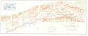
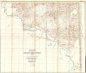
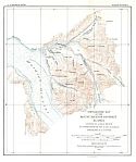
Viewing Options
Main Author:
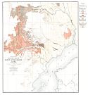
U.S. Department of the Interior, U.S. Geological Survey
Title/Description:
Topographic Map of Lower Matansuka Valley, Alaska
Publication Info:
Washington: U.S. Department of the Interior, U.S. Geological Survey, 1931
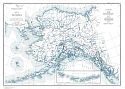
Viewing Options
Main Author:
Capps, F.S.R.
Title/Description:
Map of Alaska Showing localities from which pre-Wisconsin glacial deposits have been reported
Publication Info:
Washington D.C.: Department of the Interior, US Geological Survey, 1931; Professional Paper 170, Plate I
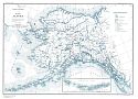
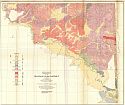
Viewing Options
Title/Description:
Map of Alaska Showing area covered by ice during the Wisconsin stage of glaciation, line of flow and submarine contours along Alaska coast
Publication Info:
Washington D.C.: Department of the Interior, US Geological Survey, 1931; Professional Paper 170, Plate 2
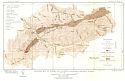
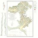
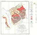
Viewing Options
Title/Description:
Geologic Map of Eureka and vicinity, Kantishna District, Alaska
Publication Info:
Washington D.C.: Department of the Interior, US Geological Survey, 1931; Bulletin 849, Plate 28
Viewing Options
Main Author:
U.S. Geological Survey
Title/Description:
Reconnaissance Topographic Map of the Dennison Fork District, Alaska
Publication Info:
Washington: Department of the Interior, U.S. Geological Survey, 1932; Bulletin 827 Plate 1
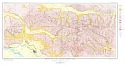
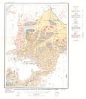
Viewing Options
Main Author:
U.S. Geological Survey
Title/Description:
Reconnaissance Geologic Map of the Dennison Fork District, Alaska
Publication Info:
Washington: Department of the Interior, U.S. Geological Survey, 1932; Bulletin 827 Plate 2
Viewing Options
Title/Description:
Geologic map and sections of the Girdwood District, Alaska
Publication Info:
Washington D.C.: Department of the Interior, US Geological Survey, 1931; Bulletin 849, Plate 33
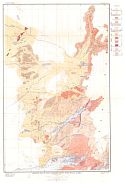
Viewing Options
Title/Description:
Geologic Map of the Fairbanks District, Alaska
Publication Info:
Washington D.C.: Department of the Interior, US Geological Survey, 1931; Bulletin 849, Plate 3
Viewing Options
Title/Description:
Topographic map of the Mount Eielson District, Alaska
Publication Info:
Washington D.C.: Department of the Interior, US Geological Survey, 1934; Bulletin 849, Plate 21
Viewing Options
Title/Description:
Topographic map of the Mount Eielson District, Alaska
Publication Info:
Washington D.C.: Department of the Interior, US Geological Survey, 1934; Bulletin 849, Plate 22
Viewing Options
Title/Description:
Geologic Recconnaissiance map of the Tonsina District, Alaska
Publication Info:
Washington D.C.: Department of the Interior, US Geological Survey, 1935; Bulletin 866, Plate 1
Viewing Options
Main Author:
Capps, Stephan R.
Title/Description:
Geologic Map of Lake Clarke-Mulchatna River Region, Alaska
Publication Info:
Washington D.C.: Department of the Interior, US Geological Survey, 1935; Bulletin 862, Plate 2
Viewing Options
Main Author:
Capps, Stephen R.
Title/Description:
Geologic Map of Mount Spurr Region, Alaska
Publication Info:
Washington D.C.: Department of the Interior, US Geological Survey, 1935; Bulletin, 862, Plate 1

