Viewing Options
Title/Description:
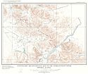
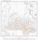
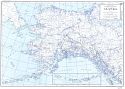
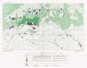
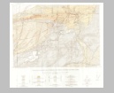
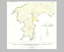
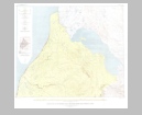
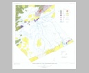
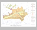
Topographic reconnaissance map of the Upper Tetling River District, Alaska
Publication Info:
Washington: Department of the Interior, US Geological Survey, 1941; Bulletin 917, Plate 2
Viewing Options
Title/Description:
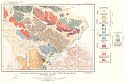
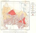
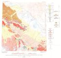
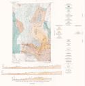
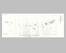
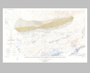
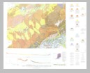
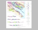
Geologic reconnaissance map of the Upper Tetling River District, Alaska
Publication Info:
Washington: Department of the Interior, US Geological Survey, 1941; Bulletin 917, Plate 3
Viewing Options
Title/Description:
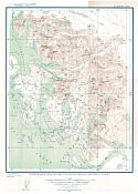
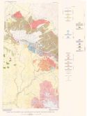
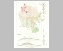
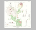
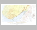
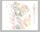
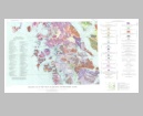
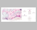
Topographic Map of the Chichagof Mining District, Alaska
Publication Info:
Washington: Department of the Interior, US Geological Survey, 1942; Bulletin 929, Plate 1
Viewing Options
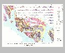
Title/Description:
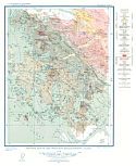
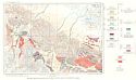
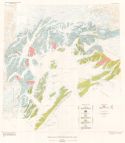
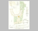
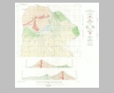
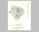
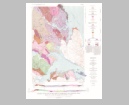
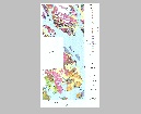
Geologic Map of the Chichagof Mining District, Alaska
Publication Info:
Washington: Department of the Interior, US Geological Survey, 1942; Bulletin 929, Plate 3
Viewing Options
Main Author:
Geographical Publishing Company
Title/Description:
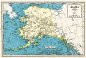
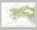
Alaska
Publication Info:
Chicago: Geographical Publishing Company, 1942; from The New International Atlas of The World, War Edition
Viewing Options
Title/Description:
Topographic reconnaissance map of the Gerstle River District, Alaska
Publication Info:
Washington: Department of the Interior, US Geological Survey, 1942; Bulletin 926, Plate2
Viewing Options
Title/Description:
Geologic reconnaissance map of the Gerstle River District, Alaska
Publication Info:
Washington: Department of the Interior, US Geological Survey, 1942; Bulletin 926, Plate 3
Viewing Options
Title/Description:
Geologic reconnaissance Map of the Nutzotin Mountains District, Alaska
Publication Info:
Washington: Department of the Interior, US Geological Survey, 1943; Bulletin 933, Plate 2
Viewing Options
Main Author:
U.S. Department of the Interior, U.S. Geological Survey
Title/Description:
Alaska
Publication Info:
Washington: U.S. Department of the Interior, U.S. Geological Survey, 1947
Viewing Options
Main Author:
U.S. Geological Survey
Title/Description:
Geologic Map and Section of the Eastern Alaska Range and Adjacent Area from the International Border to the Tok River
Publication Info:
Washington: Department of the Interior, U.S. Geological Survey; 1953; Bulletin No. 989
Viewing Options
Main Author:
U.S. Geological Survey
Title/Description:
Geological Map of the Alaska Range and Adjacent Area from the Tok River to the Delta River
Publication Info:
Washington: Department of the Interior, U.S. Geological Survey, 1953; Bulletin No. 989
Viewing Options
Main Author:
U.S. Geological Survey
Title/Description:
Geologic Map of Prince William Sound, Alaska
Publication Info:
Washington: Department of the Interior, U.S. Geological Survey, 1953; Bulletin No. 989
Viewing Options
Main Author:
U.S. Geological Survey
Title/Description:
Distribution of Permafrost and Cleared Fields in the Fairbanks Area, Alaska, 1948
Publication Info:
Washington: Department of the Interior, U.S. Geological Survey, 1953; Bulletin No. 989
Viewing Options
Main Author:
U.S. Geological Survey
Title/Description:
Geologic Map and Structure Sections of the Jarvis Creek Coal Field, Alaska
Publication Info:
Washington: Department of the Interior, U.S. Geological Survey, 1953; Bulletin No. 989
Viewing Options
Main Author:
U.S. Geological Survey
Title/Description:
Geologic Map and Sections of Great Sitkin Island, Alaska
Publication Info:
Washington: Department of the Interior, U.S. Geological Survey, 1955; Bulletin 1028-B Plate 5
Viewing Options
Main Author:
U.S. Geological Survey
Title/Description:
Geologic Map and Sections of the Dam Site, Reservoir Site, and Possible Tunnel Sites at Crescent Lake, Alaska
Publication Info:
Washington: Department of the Interior, U.S. Geological Survey, 1955; Bulletin 1031-A Plate 4
Viewing Options
Main Author:
U.S. Geological Survey
Title/Description:
Geologic Map of Eastern Part of Wishbone Hill District, Matanuska Coal Field, Alaska
Publication Info:
Washington: Department of the Interior, U.S. Geological Survey, 1956; Bulletin 1016 Plate 1
Viewing Options
Main Author:
U.S. Geological Survey
Title/Description:
Geologic Reconnaissance Map of Some Western Aleutian Islands
Publication Info:
Washington: Department of the Interior, U.S. Geological Survey, 1956; Bulletin 1028-E Plate 17
Viewing Options
Main Author:
U.S. Geological Survey
Title/Description:
Geologic Map of Northern Adak Island, Alaska
Publication Info:
Washington: Department of the Interior, U.S. Geological Survey, 1956; Bulletin 1028-C Plate 9
Viewing Options
Main Author:
U.S. Geological Survey
Title/Description:
Geologic Map of Northern Kanaga Island, Alaska
Publication Info:
Washington: Department of the Interior, U.S. Geological Survey, 1956; Bulletin 1028-D Plate 15
Viewing Options
Main Author:
U.S. Geological Survey
Title/Description:
Geologic Map of the Western Peninsula of Kanaga Island, Adreanof Islands, Aleutian Islands, Alaska
Publication Info:
Washington: Department of the Interior, U.S. Geological Survey, 1956; Bulletin 1028-D Plate 28
Viewing Options
Main Author:
U.S. Geological Survey
Title/Description:
Vegetation Map of Northwestern North America
Publication Info:
Washington: Department of the Interior, U.S. Geological Survey, 1958; Bulletin 1061-E Plate 9

Viewing Options
Main Author:
U.S. Geological Survey
Title/Description:
Geological Map of Anchorage and Vicinity, Alaska
Publication Info:
Washington: Department of the Interior, U.S. Geological Survey, 1959; Bulletin 1093 Plate 1
Viewing Options
Main Author:
U.S. Geological Survey
Title/Description:
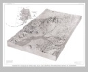
Perspective Diagram of Upper Cook Inlet Area Showing Physiographic Setting of Anchorage
Publication Info:
Washington: Department of the Interior, U.S. Geological Survey, 1959; Bulletin 1093 Plate 2
Viewing Options
Main Author:
U.S. Geological Survey
Title/Description:
Geologic Map of the Southern Part of the Homer District, Kenai Peninsula, Alaska
Publication Info:
Washington: Department of the Interior, U.S. Geological Survey, 1959; Bulletin 1058-F Plate 18
Viewing Options
Main Author:
U.S. Geological Survey
Title/Description:
Geologic Map of the Northern Part of the Homer District, Kenai Peninsula, Alaska
Publication Info:
Washington: Department of the Interior, U.S. Geological Survey, 1959; Bulletin 1058-F Plate 17

Viewing Options
Main Author:
U.S. Geological Survey
Title/Description:
Geologic Map of the Northwestern Part of Chichagof Island and Yakobi Island, Alaska
Publication Info:
Washington: Department of the Interior, U.S. Geological Survey, 1959; Bulletin 1058-E Plate 12
Viewing Options
Main Author:
U.S. Geological Survey
Title/Description:
Geologic Map of the Little Susitna District, Matanuska Coal Field, Alaska
Publication Info:
Washington: Department of the Interior, U.S. Geological Survey, 1959; Bulletin 1058-D Plate 7
Viewing Options
Main Author:
U.S. Geological Survey
Title/Description:
Geologic Map of the Geikie Inlet Area, Glacier Bay, Alaska
Publication Info:
Washington: Department of the Interior, U.S. Geological Survey, 1959; Bulletin 1058-C Plate 6
Viewing Options
Main Author:
U.S. Geological Survey
Title/Description:
Geologic Map and Sections of Little Sitkin Island, Alaska
Publication Info:
Washington: Department of the Interior, U.S. Geological Survey, 1959; Bulletin 1028-H Plate 23

Viewing Options
Main Author:
U.S. Geological Survey
Title/Description:
Generalized Geologic Map of Delarof and Westernmost Andreanof Islands, Aleutian Islands, Alaska
Publication Info:
Washington: Department of the Interior, U.S. Geological Survey, 1959; Bulletin 1028-I Plate 27

Viewing Options
Main Author:
U.S. Geological Survey
Title/Description:
Preliminary Geologic Map of Gareloi Island, Alaska
Publication Info:
Washington: Department of the Interior, U.S. Geological Survey, 1959; Bulletin 1028-J Plate 33

Viewing Options
Main Author:
U.S. Geological Survey
Title/Description:
Geologic Map of Ogliuga and Skagul Islands, Delarof Islands, Aleutian Islands, Alaska
Publication Info:
Washington: Department of the Interior, U.S. Geological Survey, 1959; Bulletin 1028-L Plate 30

Viewing Options
Main Author:
U.S. Geological Survey
Title/Description:
Geologic Map of Kavalga Island, Delarof Island, Aleutian Islands, Alaska
Publication Info:
Washington: Department of the Interior, U.S. Geological Survey, 1959; Bulletin 1028-M Plate 29

Viewing Options
Main Author:
U.S. Geological Survey
Title/Description:
Geologic Map of Pavlof Volcano and Vicinity, Alaska
Publication Info:
Washington: Department of the Interior, U.S. Geological Survey, 1959; Bulletin 1028-N Plate 3

Viewing Options
Main Author:
U.S. Geological Survey
Title/Description:
Geologic Map and Sections of the Windy Creek Area, Alaska
Publication Info:
Washington: Department of the Interior, U.S. Geological Survey, 1959; Bulletin 1039-D Plate 11
Viewing Options
Main Author:
U.S. Geological Survey
Title/Description:
Bedrock Geologic Map of the Upper Kuskokwin Region, Alaska
Publication Info:
Washington: Department of the Interior, U.S. Geological Survey, 1960; Bulletin 1071-G Plate 21
Viewing Options
Main Author:
U.S. Geological Survey
Title/Description:
Geological Map and Sections of the Mount McKinley Quadrangle, Alaska
Publication Info:
Washington: Department of the Interior, U.S. Geological Survey, 1961; Bulletin 1108-A Plate 1
Viewing Options
Main Author:
U.S. Geological Survey
Title/Description:
Geologic Map of the Craig Quadrangle, Southeastern Alaska
Publication Info:
Washington: Department of the Interior, U.S. Geological Survey, 1961; Bulletin 1108-B Plate 1
Viewing Options
Main Author:
U.S. Geological Survey
Title/Description:
Geologic Map of Part of the Craig C-Z Quadrangle and Adjoining Areas, Prince of Wales Island, Southeastern Alaska
Publication Info:
Washington: Department of the Interior, U.S. Geological Survey, 1961; Bulletin 1058-H Plate 33
Viewing Options
Main Author:
U.S. Geological Survey
Title/Description:
Geologic Map of the Yukon Flats District, Alaska
Publication Info:
Washington: Department of the Interior, U.S. Geological Survey, 1962; Bulletin 1111-H Plate 42
Viewing Options
Main Author:
U.S. Geological Survey
Title/Description:
Geologic Map and Sections of the Freshwater Bay Area, Chichagof Island, Alaska
Publication Info:
Washington: Department of the Interior, U.S. Geological Survey, 1963; Bulletin 1108-C Plate 1
Viewing Options
Main Author:
U.S. Geological Survey
Title/Description:
Geologic Map of Part of the Fairbanks Area, Alaska
Publication Info:
Washington: Department of the Interior, U.S. Geological Survey, 1963; Bulletin 1111-I Plate 43

Viewing Options
Main Author:
U.S. Geological Survey
Title/Description:
Geologic Map of the Southern Part of the Fairweather Range, Alaska
Publication Info:
Washington: Department of the Interior, U.S. Geological Survey, 1963; Bulletin 1121-F Plate 1

Viewing Options
Main Author:
U.S. Geological Survey
Title/Description:
Geologic Map of the Imuruk Lake Area, Alaska
Publication Info:
Washington: Department of the Interior, U.S. Geological Survey, 1963; Bulletin 1141-C Plate 1
Viewing Options
Main Author:
U.S. Geological Survey
Title/Description:
Geologic Map of Mount Fairweather B-1, B-2, C-1, D-1, and D-2 Quadrangles, Alaska
Publication Info:
Washington: Department of the Interior, U.S. Geological Survey, 1963; Bulletin 1121-K Plate 1
Viewing Options
Main Author:
U.S. Geological Survey
Title/Description:
Geologic Map and Sections of Parts of Mount Fairweather D-1 and D-2 Quadrangles, Alaska
Publication Info:
Washington: Department of the Interior, U.S. Geological Survey, 1963; Bulletin 1121-K Plate 2

Viewing Options
Main Author:
U.S. Geological Survey
Title/Description:
Geologic Map of the Bokan Mountain Uranium-Thorium Area, Southeastern Alaska
Publication Info:
Washington: Department of the Interior, U.S. Geological Survey, 1963; Bulletin 1154 Plate 1

