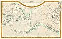
Viewing Options
Main Author:
Gridley, Enoch G.
Title/Description:
A Chart of the Nth West Coast of America & the Nth East Coast of Asia Showing Discoveries that have lately been made in those parts
Publication Info:
Charleston: Samuel Ethridge, 1804; from Morse's The American Gazetter
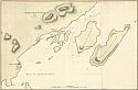
Viewing Options
Main Author:
Lisiansky, Urey
Title/Description:
Harbour of St. Paul (Kodiak Island)
Publication Info:
London: John Booth 1805; from A Voyage Round the World: in the year 1803-1806
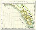
Viewing Options
Main Author:
Vandermaelen, Philippe Marie Guillaume
Title/Description:
Amer. Sep. Partie. De L'Amerique Russe. No. 23 (From Port Langara North to Port Maulgrave)
Publication Info:
Brussels: 1827
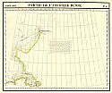
Viewing Options
Main Author:
Vandermaelen, Philippe Marie Guillaume
Title/Description:
Amer. Sep. Partie de L'Amerique Russe. No. 5 (Alaska Coast from Chicmarief Bay to Cook's Glacier)
Publication Info:
Brussels: 1827
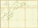
Viewing Options
Main Author:
Davidson, G.
Title/Description:
North West Coast of America. Sheet No. 3. Icy Bay to Seven Islands
Publication Info:
Washington D.c: U.S. Coast Survey, 1868
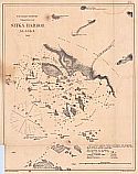
Viewing Options
Main Author:
Lindenkohl, H.
Title/Description:
Sitka Harbor, Alaska
Publication Info:
Washington, D.c: U.S. Coast Survey, 1869; Chart #21
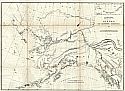
Viewing Options
Main Author:
Peirce, Benjamin
Title/Description:
Alaska and Adjoining Territory
Publication Info:
Washington: U.S. Coast Survey. 1869
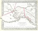
Viewing Options
Main Author:
Mitchell, S. Augustus
Title/Description:
North Western America showing the territory ceded by Russia to the United States
Publication Info:
Philadelphia: S. Augustus Mitchell, 1872

