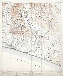
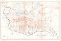
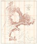
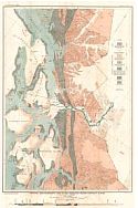
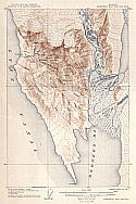
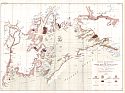
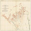
Viewing Options
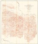
Main Author:
U.S. Geological Survey
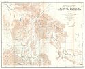
Title/Description:
Nome Special Map
Publication Info:
Washington: Department of the Interior, U.S. Geological Survey, 1906
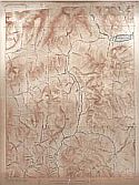
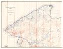
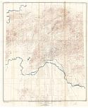
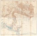
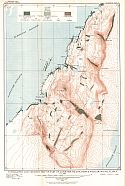
Viewing Options
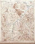
Main Author:
U.S. Geological Survey
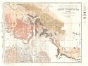
Title/Description:
Grand Central Special Map
Publication Info:
Washington: Department of the Interior, U.S. Geological Survey, 1906
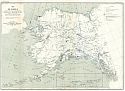
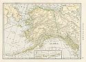
Viewing Options
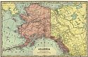
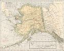
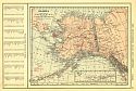
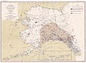
Title/Description:
Alaska
Publication Info:
Chicago: Rand McNally and Company from the Business Atlas and Shippers Guide

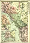
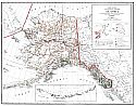
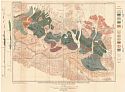
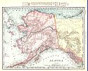
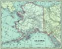
Viewing Options
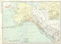
Title/Description:
Alaska
Publication Info:
New York: C.S. Hammond and Company, 1906; from the Pictoral Atlas of the World
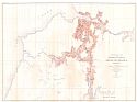
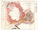
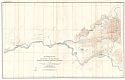
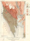
Viewing Options
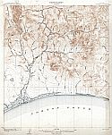
Main Author:
U.S. Geological Survey
Title/Description:
Reconnaissance Map of the Northern Portion of Kenai Peninsula, Alaska
Publication Info:
Washington: Department of the Interior, U.S. Geological Survey, 1906; Bulletin 277, Plate 2
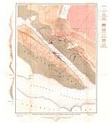
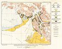
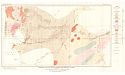
Viewing Options
Main Author:
U.S. Geological Survey
Title/Description:
Geologic map of the Vicinity of Juneau with Cross Section
Publication Info:
Washington: Department of the Interior, U.S. Geological Survey, 1906; Bulletin 287, Plate 4
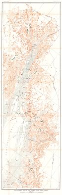
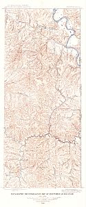
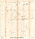
Viewing Options
Main Author:
U.S. Geological Survey
Title/Description:
Topographic Map of the Juneau Gold Belt, Alaska
Publication Info:
Washington: Department of the Interior, U.S. Geological Survey, 1906; Bulletin 287, Plate 36
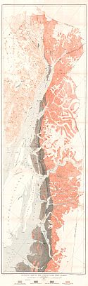
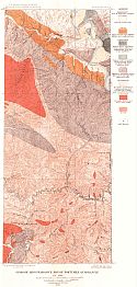
Viewing Options
Main Author:
U.S. Geological Survey
Title/Description:
Geologic Map of the Juneau Gold Belt, Alaska
Publication Info:
Washington: Department of the Interior, U.S. Geological Survey, 1906; Bulletin 287, Plate 37
Viewing Options
Main Author:
U.S. Geological Survey
Title/Description:
Topographic Reconnaissance Map of Matanuska Valley and Adjacent Regions, Alaska
Publication Info:
Washington: Department of the Interior, U.S. Geological Survey, 1906; Bulletin 289, Plate 1
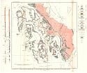
Viewing Options
Main Author:
U.S. Geological Survey
Title/Description:
Reconnaissance Map of Yukon-Tanana Region, Alaska, Circle Quadrangle
Publication Info:
Washington: Department of the Interior, U.S. Geological Survey, 1906; Bulletin 295, Plate 1
Viewing Options
Main Author:
U.S. Geological Survey
Title/Description:
Casadepaga Quadrangle
Publication Info:
Washington: Department of the Interior, U.S. Geological Survey, 1907
Viewing Options
Main Author:
U.S. Geological Survey
Title/Description:
Soloman Quadrangle
Publication Info:
Washington: Department of the Interior, U.S. Geological Survey, 1907
Viewing Options
Main Author:
Cram, George F.
Title/Description:
Alaska
Publication Info:
Chicago: George F. Cram, 1907; from Cram's Standard American Atlas
Viewing Options
Main Author:
P.F. Collier and Son
Title/Description:
Alaska
Publication Info:
New York: P.F. Collier and Son, 1907; from The New Encyclopedic Atlas and Gazetteer of the World
Viewing Options
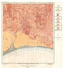
Main Author:
U.S. Geological Survey
Title/Description:
Map of the Bering River Coal Field showing Distribution of various kinds of coal and location of the coal sections and coal samples
Publication Info:
Washington: Department of the Interior, U.S. Geological Survey, 1907; Bulletin 335, Plate 8
Viewing Options
Main Author:
U.S. Geological Survey
Title/Description:
Geologic Map and Sections of Controller Bay Region, Alaska
Publication Info:
Washington: Department of the Interior, U.S. Geological Survey, 1907; Bulletin 335, Plate 5
Viewing Options
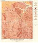
Main Author:
U.S. Geological Survey
Title/Description:
Topographic Map of Controller Bay Region, Alaska
Publication Info:
Washington: Department of the Interior, U.S. Geological Survey, 1907; Bulletin 335, Plate 2
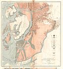
Viewing Options
Main Author:
U.S. Geological Survey
Title/Description:
Topographic Reconnaissance Map of the Southern Part of Seward Peninsula
Publication Info:
Washington: Department of the Interior, U.S. Geological Survey, 1907; Bulletin 328, Plate 8
Viewing Options
Main Author:
U.S. Geological Survey
Title/Description:
Reconnaissance Map of Northwestern Part Seward Peninsula, Alaska
Publication Info:
Washington: Department of the Interior, U.S. Geological Survey, 1907; Bulletin 328, Plate 9
Viewing Options
Main Author:
U.S. Geological Survey
Title/Description:
Geologic Reconnaissance Map of the Southern Part of Seward Peninsula, Alaska
Publication Info:
Washington: Department of the Interior, U.S. Geological Survey, 1907; Bulletin 328, Plate 10
Viewing Options
Main Author:
U.S. Geological Survey
Title/Description:
Geologic Reconnaissance Map of the Northwester Part of Seward Peninsula
Publication Info:
Washington: Department of the Interior, U.S. Geological Survey, 1907; Bulletin 328, Plate 11
Viewing Options
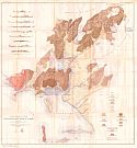
Main Author:
U.S. Geological Survey
Title/Description:
Reconnaissance Map of Mantanuska and Talkeetna Region, Alaska
Publication Info:
Washington: Department of the Interior, U.S. Geological Survey, 1907; Bulletin 327, Plate 1
Viewing Options
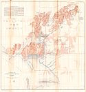
Main Author:
U.S. Geological Survey
Title/Description:
Geologic Reconnaissance Map of Mantanuska and Talkeetna Region, Alaska
Publication Info:
Washington: Department of the Interior, U.S. Geological Survey, 1907; Bulletin 327, Plate 2
Viewing Options
Main Author:
U.S. Geological Survey
Title/Description:
Geologic Reconnaissance Map of the Ketchikan and Wrangell Mining Districts, Southeasterm Alaska
Publication Info:
Washington: Department of the Interior, U.S. Geological Survey, 1907; Bulletin 347, Plate 1
Viewing Options
Main Author:
U.S. Geological Survey
Title/Description:
Geologic Reconnaissance Map of part of the Ketchikan Mining District, Alaska
Publication Info:
Washington: Department of the Interior, U.S. Geological Survey, 1907; Bulletin 347, Plate 2
Viewing Options
Main Author:
U.S. Geological Survey
Title/Description:
Geologic Reconnaissance Map of the Wrangell Mining District, Alaska
Publication Info:
Washington: Department of the Interior, U.S. Geological Survey, 1907; Bulletin 347, Plate 3
Viewing Options
Main Author:
U.S. Geological Survey
Title/Description:
Reconnaissance Map of the Fairbanks Quadrangle, Alaska
Publication Info:
Washington: Department of the Interior, U.S. Geological Survey, 1907; Bulletin 337, Plate 4
Viewing Options
Main Author:
U.S. Geological Survey
Title/Description:
Reconnaissance Map of Rampart Quadrangle, Yukon-Tanana Region, Alaska
Publication Info:
Washington: Department of the Interior, U.S. Geological Survey, 1907; Bulletin 337, Plate 5
Viewing Options
Main Author:
Berthrong, I.P.
Title/Description:
Alaska
Publication Info:
Washington: Department of the Interior, General Land Office, 1908
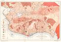
Viewing Options
Main Author:
U.S. Geological Survey
Title/Description:
Berners Bay Special Map
Publication Info:
Washington: Department of the Interior, U.S. Geological Survey, 1908
Viewing Options
Main Author:
U.S. Geological Survey
Title/Description:
Reconnaissance Map of Chitina Quadrangle, Copper River Region, Alaska
Publication Info:
Washington: Department of the Interior, U.S. Geological Survey, 1908; Bulletin 374, Plate 1
Viewing Options
Main Author:
U.S. Geological Survey
Title/Description:
Geologic Reconnaissance Map and Sections of the Chitina Copper Belt, Alaska
Publication Info:
Washington: Department of the Interior, U.S. Geological Survey, 1908; Bulletin 374, Plate 2
Viewing Options
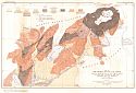
Main Author:
U.S. Geological Survey
Title/Description:
Map of Alaska showing the known distribution of mineral resources
Publication Info:
Washington: Department of the Interior, U.S. Geological Survey, 1908; Bulletin 345, Plate 1
Viewing Options
Main Author:
U.S. Geological Survey
Title/Description:
Topographic Reconnaissance Map of Fortymile Quadrangle
Publication Info:
Washington: Department of the Interior, U.S. Geological Survey, 1908; Bulletin 375, Plate 4
Viewing Options
Main Author:
U.S. Geolofical Survey
Title/Description:
Geologic Reconnaissance Map of Fortymile Quadrangle
Publication Info:
Washington: Department of the Interior, U.S. Geological Survey, 1908; Bulletin 375, Plate 5
Viewing Options
Main Author:
Hammond, C.S.
Title/Description:
Alaska
Publication Info:
New York: C.S. Hammond & Co. 1908; from Hammond's Handy Atlas of the World
Viewing Options
Main Author:
Rand McNally and Company
Title/Description:
Alaska
Publication Info:
Chicago: Rand McNally and Company, 1908; from New Ideal State and County Survey and Atlas
Viewing Options
Main Author:
Patten, William and J.E. Homas
Title/Description:
Alaska
Publication Info:
New York: P.F. Collier and Son, 1909; from The New Encyclopedic Atlas and Gazetteer of the World
Viewing Options
Main Author:
Cram, George F.
Title/Description:
Alaska
Publication Info:
Chicago: George F. Cram, c.1909; from the Art of our Country
Viewing Options
Main Author:
U.S. Geological Survey
Title/Description:
Geologic Reconnaissance Map of the Yakutat Bay Region, Alaska
Publication Info:
Washington: U.S. Deparment of the Interior, Geological Survey
Viewing Options
Main Author:
U.S. Geological Survey
Title/Description:
Reconnaissance Map of the Middle Kuskokwim and Lower Yukon Regions
Publication Info:
Washington: Department of the Interior, U.S. Geological Survey, 1909; Bulletin 410, Plate 1
Viewing Options
Main Author:
U.S. Geological Survey
Title/Description:
Geologic Reconnaissance Map of Prince William Sound, Alaska
Publication Info:
Washington: Department of the Interior, U.S. Geological Survey, 1909; Bulletin 443, Plate 2
Viewing Options
Main Author:
U.S. Geological Survey
Title/Description:
Topographic and Geologic Map of Part of Latouche Island, Prince William Sound, Alaska
Publication Info:
Washington: Department of the Interior, U.S. Geological Survey, 1909; Bulletin 443, Plate 12
Viewing Options
Main Author:
U.S. Geological Survey
Title/Description:
Geologic Map of Solomon Quadrangle, Alaska
Publication Info:
Washington: Department of the Interior, U.S. Geological Survey, 1909; Bulletin 433, Plate 6
Viewing Options
Main Author:
U.S. Geological Survey
Title/Description:
Geologic Map of Casadepaga Quadrangle, Alaska
Publication Info:
Washington: Department of the Interior, U.S. Geological Survey, 1909; Bulletin 433, Plate 7
Viewing Options
Main Author:
U.S. Geological Survey
Title/Description:
Reconnaissance Map of Headwater region of Nabesna and White Rivers, Alaska
Publication Info:
Washington: Department of the Interior, U.S. Geological Survey, 1909; Bulletin 417, Plate 1
Viewing Options
Main Author:
U.S. Geological Survey
Title/Description:
Geologic Reconnaissance Map of Headwater Regions of Nabesna and White Rivers, Alaska
Publication Info:
Washington: Department of the Interior, U.S. Geological Survey, 1909; Bulletin 417, Plate 2
Viewing Options
Main Author:
U.S. Geological Survey
Title/Description:
Map of Alaska Showing the area disturbed by sensible shocks during the earthquakes of September, 1899 in and around Yakutat Bay
Publication Info:
Washington: U.S. Deparment of the Interior, Geological Survey
Viewing Options
Title/Description:
Alaska
Publication Info:
Chicago: Rand McNally and Company, 1910; from Enlarged Business Atlas and Shippers Guide
Viewing Options
Main Author:
U.S. Geological Survey
Title/Description:
Geologic Reconnaissance Map of the Yentna Mining District, Alaska
Publication Info:
Washington: U.S. Deparment of the Interior, Geological Survey
Viewing Options
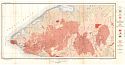
Main Author:
U.S. Geological Survey
Title/Description:
Geologic Map of Berners Bay Region, Alaska
Publication Info:
Washington: Department of the Interior, U.S. Geological Survey, 1910; Bulletin 446, Plate 2
Viewing Options
Main Author:
U.S. Geological Survey
Title/Description:
Geologic Map of Nulato-Norton Bay Region, Alaska
Publication Info:
Washington: Department of the Interior, U.S. Geological Survey, 1910; Bulletin 449, Plate 5

