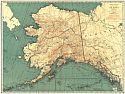
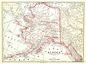
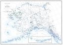
Viewing Options
Main Author:
Rand McNally and Company
Title/Description:
Alaska
Publication Info:
Chicago: Rand McNally and Company, 1921; from the Commercial Atlas of America
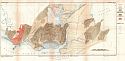
Viewing Options
Main Author:
U.S. Geological Survey
Title/Description:
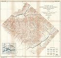
Geologic Map of Controller Bay or Katalla Oil Field, Alaska
Publication Info:
Washington: Department of the Interior, U.S. Geological Survey, 1921; Bulletin 719 Plate 4
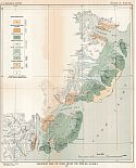
Viewing Options
Main Author:
U.S. Geological Survey
Title/Description:
Geologic Map of Cook Anlet Oil Fields, Alaska
Publication Info:
Washington: Department of the Interior, U.S. Geological Survey, 1921; Bulletin 719 Plate 8
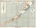
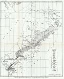
Viewing Options
Main Author:
U.S. Geological Survey
Title/Description:
Geologic Reconnaissance Map of the Alaska Peninsula
Publication Info:
Washington: Department of the Interior, U.S. Geological Survey, 1921; Bulletin 719 Plate 9
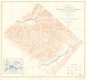
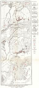
Viewing Options
Main Author:
U.S. Department of the Interior, U.S. Geological Survey
Title/Description:
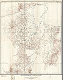
Topographic Map of Kotsina-Kuskulana District, Copper River Region, Alaska
Publication Info:
Washington: U.S. Department of the Interior, U.S. Geological Survey, 1922
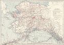
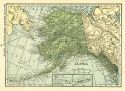
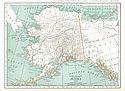
Viewing Options
Main Author:
C.S. Hammond and Company
Title/Description:
Alaska
Publication Info:
New York: C.S. Hammond and Company, 1922; from the New World Looseleaf Atlas
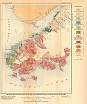
Viewing Options
Main Author:
U.S. Geological Survey
Title/Description:
Geologic Reconnaissance Map of the Southwestern Map Part of Kenai Peninsula, Alaska
Publication Info:
Washington: Department of the Interior, U.S. Geological Survey, 1922; Bulletin 742 Plate 1
Viewing Options
Main Author:
U.S. Geological Survey
Title/Description:
Topographic and Geologic Reconnaissance Map of the York Tin Region, Seward Peninsula, Alaska
Publication Info:
Washington: Department of the Interior, U.S. Geological Survey, 1922; Bulletin 733 Plate 1
Viewing Options
Main Author:
U.S. Geological Survey
Title/Description:
Reconnaissance Map of Ruby District, Alaska
Publication Info:
Washington: Department of the Interior, U.S. Geological Survey, 1923; Bulletin 754 Plate 1
Viewing Options
Main Author:
U.S. Geological Survey
Title/Description:
Reconnaissance Map of Innoko-Iditarod Region, Alaska
Publication Info:
Washington: Department of the Interior, U.S. Geological Survey, 1923; Bulletin 754 Plate 2
Viewing Options
Main Author:
U.S. Geological Survey
Title/Description:
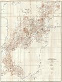
Topographic Map of Kotsina-Kuskulana District, Copper River Region, Alaska
Publication Info:
Washington: Department of the Interior, U.S. Geological Survey, 1923; Bulletin 745 Plate 2
Viewing Options
Main Author:
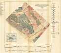
U.S. Geological Survey
Title/Description:
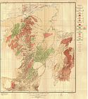
Geologic Map and Sections of the Kotsina-Kuskulana District, Copper River Region, Alaska
Publication Info:
Washington: Department of the Interior, U.S. Geological Survey, 1923; Bulletin 745 Plate 3
Viewing Options
Main Author:
Cram, George F.
Title/Description:
Alaska
Publication Info:
Chicago: George F. Cram Company, 1923; from Cram's Unrivaled Atlas of the World
Viewing Options
Main Author:
Funk and Wagnalls Company
Title/Description:
Alaska
Publication Info:
New York: Funk and Wagnalls Company, 1923; from Atlas of the World and Gazetteer
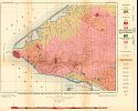
Viewing Options
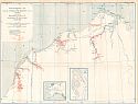
Main Author:
U.S. Geological Survey
Title/Description:
Geologic Reconnaissance Map of Cold Bay-Chignik District, Alaska Peninsula
Publication Info:
Washington: Department of the Interior, U.S. Geological Survey, 1924; Bulletin 755 Plate 8
Viewing Options
Main Author:
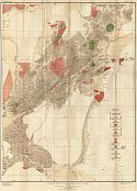
U.S. Geological Survey
Title/Description:
Map of the Region Tributary to the Alaska Railroad Showing Geology and Mineral Deposits
Publication Info:
Washington: Department of the Interior, U.S. Geological Survey, 1924; Bulletin 755 Plate 1
Viewing Options
Main Author:
U.S. Geological Survey
Title/Description:
Geologic Map of Ruby District, Alaska
Publication Info:
Washington: Department of the Interior, U.S. Geological Survey, 1924; Bulletin 754 Plate 3
Viewing Options
Main Author:
U.S. Geological Survey
Title/Description:
Geologic Map of Innoko-Iditarod Region, Alaska
Publication Info:
Washington: Department of the Interior, U.S. Geological Survey, 1924; Bulletin 754 Plate 4
Viewing Options
Main Author:
U.S. Geological Survey
Title/Description:
Northwestern Part of Naval Petroleum Reserve No. 4, Alaska
Publication Info:
Washington: Department of the Interior, U.S. Geological Survey, 1924; Bulletin 772 Plate 1
Viewing Options
Main Author:
Reynolds, Francis J.
Title/Description:
Alaska
Publication Info:
New York: P.F. Collier and Son Company, 1924; from The New World Atlas and Gazetteer
Viewing Options
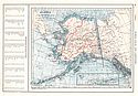
Main Author:
U.S. Department of the Interior, U.S. Geological Survey
Title/Description:
Map of Alaska
Publication Info:
Washington: U.S. Department of the Interior, U.S. Geological Survey, 1925
Viewing Options
Main Author:
Rand McNally and Company
Title/Description:
Alaska
Publication Info:
Chicago: Rand McNally and Company, 1925; from Premier Atlas of the World

