Viewing Options
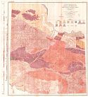
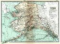
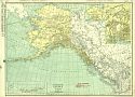
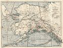
Main Author:
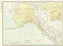
Rand McNally & Company
Title/Description:
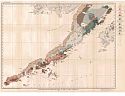
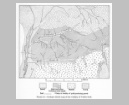
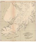
Alaska
Publication Info:
Chicago: Rand McNally & Co., 1911; from Rand McNally & Co.'s Indexed Atlas
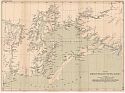
Viewing Options
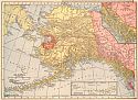
Title/Description:
Alaska
Publication Info:
New York: C.S. Hammond and Company, 1911; from Hammond's Modern Atlas of the World
Viewing Options
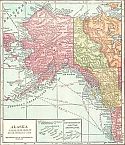
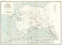
Title/Description:
Alaska
Publication Info:
Chicago: Geographical Publishing Company, 1911
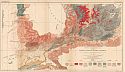
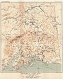
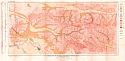
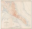
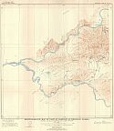
Viewing Options
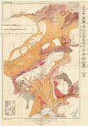
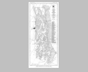
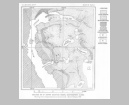
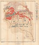
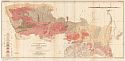
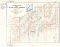
Main Author:
U.S. Geological Survey
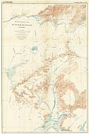
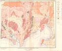
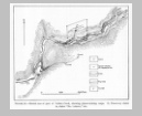
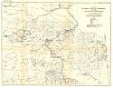
Title/Description:
Geologic Reconnaissance Map of the Mount Mckinley Region, Alaska
Publication Info:
Washington: U.S. Deparment of the Interior, Geological Survey
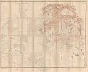
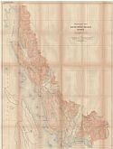
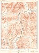
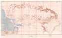
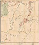
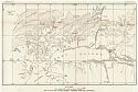
Viewing Options
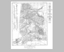
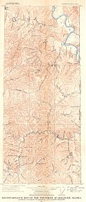
Main Author:
U.S. Geological Survey
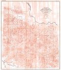
Title/Description:
Reconnaissance Map of the Mount Mckinley Region, Alaska
Publication Info:
Washington: U.S. Deparment of the Interior, Geological Survey
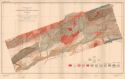
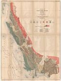
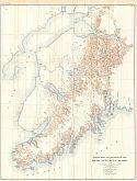
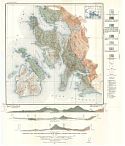
Viewing Options
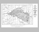
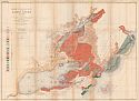
Main Author:
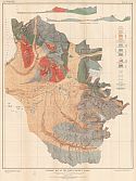
U.S. Geological Survey
Title/Description:
Geologic Map of the Nizina District, Alaska
Publication Info:
Washington: Department of the Interior, U.S. Geological Survey, 1911; Bulletin 448, Plate 3
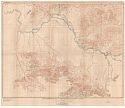
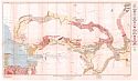
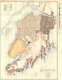
Viewing Options
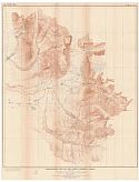
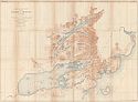
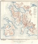
Main Author:
U.S. Geological Survey
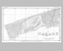
Title/Description:
Topographic Map of the Nizina District, Alaska
Publication Info:
Washington: Department of the Interior, U.S. Geological Survey, 1911; Bulletin 448, Plate 2
Viewing Options
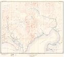
Main Author:
U.S. Geological Survey
Title/Description:
Reconnaissance Map of Southeastern Seward Peninsula, Alaska
Publication Info:
Washington: Department of the Interior, U.S. Geological Survey, 1911; Bulletin 449, Plate 1
Viewing Options
Main Author:
U.S. Geological Survey
Title/Description:
Geologic Map of Southeastern Seward Peninsula, Alaska
Publication Info:
Washington: Department of the Interior, U.S. Geological Survey, 1911; Bulletin 449, Plate 6
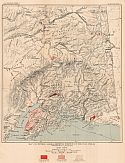
Viewing Options
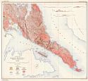
Main Author:
U.S. Geological Survey
Title/Description:
Geologic Reconnaissance Map of the Alaska Peninsula
Publication Info:
Washington: Department of the Interior, U.S. Geological Survey, 1911; Bulletin 467, Plate 6
Viewing Options
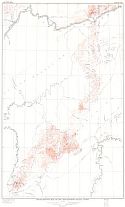
Main Author:
U.S. Geological Survey
Title/Description:
Map of Alaska Showing Distribution of Metalliferous Deposits
Publication Info:
Washington: Department of the Interior, U.S. Geological Survey, 1911; Bulletin 480, Plate 1
Viewing Options
Main Author:
U.S. Geological Survey
Title/Description:
Reconnaissance Map of Circle Quadrangle Yukon-Tanana Region, Alaska
Publication Info:
Washington: Department of the Interior, U.S. Geological Survey, 1911; Bulletin 538, Plate 1
Viewing Options
Main Author:
U.S. Geological Survey
Title/Description:
Geologic Reconnaissance Map of the Circle Quadrangle Yukon-Tanana region, Alaska
Publication Info:
Washington: Department of the Interior, U.S. Geological Survey, 1911; Bulletin 538, Plate 2
Viewing Options
Main Author:
U.S. Geological Survey
Title/Description:
Geological Reconnaissance Map of Southeastern Alaska
Publication Info:
Washington: Government Printing Office, 1911; Bulletin 480, Mineral Resources of Alaska
Viewing Options
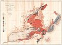
Main Author:
U.S. Geological Survey
Title/Description:
Geological Sketch Map of Central Alaska
Publication Info:
Washington: Government Printing Office, 1911; Bulletin 480, Mineral Resources of Alaska
Viewing Options
Main Author:
U.S. Geological Survey
Title/Description:
Geological Sketch Map of Yukon-Tanana Region
Publication Info:
Washington: Government Printing Office, 1911; Bulletin 480, Mineral Resources of Alaska
Viewing Options
Main Author:
U.S. Geological Survey
Title/Description:
Geological Sketch Map of Auriferous Lodes in Fairbanks District
Publication Info:
Washington: Government Printing Office, 1911; Bulletin 480, Mineral Resources of Alaska
Viewing Options
Main Author:
U.S. Geological Survey
Title/Description:
Geological Sketch Map of Kotsina-Chitina Copper Belt
Publication Info:
Washington: Government Printing Office, 1911; Bulletin 480, Mineral Resources of Alaska
Viewing Options
Main Author:
U.S. Geological Survey
Title/Description:
Geological Sketch Map of West End of Seward Peninsula, Showing Relation of Tin Deposits to Intrusive Rocks
Publication Info:
Washington: Government Printing Office, 1911; Bulletin 480, Mineral Resources of Alaska
Viewing Options
Main Author:
U.S. Geological Survey
Title/Description:
Sketch Map of Upper Susitna and Chistochina River Basins
Publication Info:
Washington: Government Printing Office, 1911; Bulletin 480, Mineral Resources of Alaska
Viewing Options
Main Author:
U.S. Geological Survey
Title/Description:
Geologic Sketch Map of the Vicinity of Valdez Creek
Publication Info:
Washington: Government Printing Office, 1911; Bulletin 480, Mineral Resources of Alaska
Viewing Options
Main Author:
U.S. Geological Survey
Title/Description:
Sketch Map of Part of Valdez Creek Showing Placer-Mining Camps
Publication Info:
Washington: Government Printing Office, 1911; Bulletin 480, Mineral Resources of Alaska
Viewing Options
Main Author:
U.S. Geological Survey
Title/Description:
Preliminary Geologic Map of Part of the Matanuska Coal Field
Publication Info:
Washington: Government Printing Office, 1911; Bulletin 480, Mineral Resources of Alaska
Viewing Options
Main Author:
U.S. Geological Survey
Title/Description:
Geologic Sketch Map of Willow Creek Region
Publication Info:
Washington: Government Printing Office, 1911; Bulletin 480, Mineral Resources of Alaska
Viewing Options
Main Author:
U.S. Geological Survey
Title/Description:
Sketch Map of Bonnfield Region
Publication Info:
Washington: Government Printing Office, 1911; Bulletin 480, Mineral Resources of Alaska
Viewing Options
Main Author:
U.S. Geological Survey
Title/Description:
Map of Southwestern Alaska, Showing Location of Innoka and Iditarod Placer Districts
Publication Info:
Washington: Government Printing Office, 1911; Bulletin 480, Mineral Resources of Alaska
Viewing Options
Main Author:
U.S. Geological Survey
Title/Description:
Geological Sketch Map of Shungnak Region
Publication Info:
Washington: Government Printing Office, 1911; Bulletin 480, Mineral Resources of Alaska
Viewing Options
Main Author:
U.S. Geological Survey
Title/Description:
Sketch Map of Southeastern Part of Squirrel River Basin
Publication Info:
Washington: Government Printing Office, 1911; Bulletin 480, Mineral Resources of Alaska
Viewing Options
Main Author:
U.S. Geological Survey
Title/Description:
Geological Map of Copper Mountain Region, Southeastern Alaska
Publication Info:
Washington: Government Printing Office, 1911; Bulletin 480, Mineral Resources of Alaska
Viewing Options
Main Author:
U.S. Geological Survey
Title/Description:
Geologic Reconnaissance Map of the Iliamna Region
Publication Info:
Washington, D.C.: U.S. Geological Survey Department of the Interior, 1912
Viewing Options
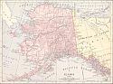
Main Author:
Rand McNally and Company
Title/Description:
Alaska
Publication Info:
Chicago: Rand McNally and Company, 1912; from The Rand McNally Imperial Atlas of the World
Viewing Options
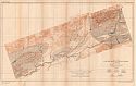
Main Author:
U.S. Geological Survey
Title/Description:
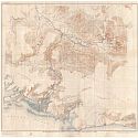
Map of the Lower Matanuska Valley, Alaska
Publication Info:
Washington: Department of the Interior, U.S. Geological Survey, 1912; Bulletin 500, Plate 18
Viewing Options
Main Author:
U.S. Geological Survey
Title/Description:
Geologic Reconnaissance Map of the Matanuska Valley, Alaska
Publication Info:
Washington: Department of the Interior, U.S. Geological Survey, 1912; Bulletin 500, Plate 3
Viewing Options
Main Author:
U.S. Geological Survey
Title/Description:
Geologic Map of the Lower Matanuska Valley, Alaska
Publication Info:
Washington: Department of the Interior, U.S. Geological Survey, 1912; Bulletin 500, Plate 5
Viewing Options
Main Author:
U.S. Geological Survey
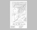
Title/Description:
Map of Central Alaska, showing positions of the Coal Fields
Publication Info:
Washington: Department of the Interior, U.S. Geological Survey, 1912; Bulletin 500 Plate 1
Viewing Options
Main Author:
U.S. Geological Survey
Title/Description:
Reconnaissance Map of Headwater Region of Gulkana and Susitna Rivers, Alaska
Publication Info:
Washington: Department of the Interior, U.S. Geological Survey, 1912; Bulletin 498 Plate 1
Viewing Options
Main Author:
U.S. Geological Survey
Title/Description:
Geologic Reconnaissance Map of Headwater Region of Gulkana Susitna Rivers, Alaska
Publication Info:
Washington: Department of the Interior, U.S. Geological Survey, 1912; Bulletin 498 Plate 2
Viewing Options
Main Author:
U.S. Geological Survey
Title/Description:
Reconnaissance Map of the Illamna Region, Alaska
Publication Info:
Washington: Department of the Interior, U.S. Geological Survey, 1912; Bulletin 485 Plate 1
Viewing Options
Main Author:
U.S. Geological Survey
Title/Description:
Geologic Reconnaissance Map of the Illamna Region, Alaska
Publication Info:
Washington: Department of the Interior, U.S. Geological Survey, 1912; Bulletin 485 Plate 2
Viewing Options
Main Author:
U.S. Geological Survey
Title/Description:
Map of Alaska Showing Distribution of Mineral Deposits
Publication Info:
Washington: Department of the Interior, U.S. Geological Survey, 1912; Bulletin 520 Plate 1
Viewing Options
Main Author:
U.S. Geological Survey
Title/Description:
Relief Map of Central Alaska
Publication Info:
Washington: Department of the Interior, U.S. Geological Survey, 1912; Bulletin 520 Plate 3
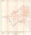
Viewing Options
Main Author:
U.S. Geological Survey
Title/Description:
Topographic Map of Eagle River Region, Alaska
Publication Info:
Washington: Department of the Interior, U.S. Geological Survey, 1912; Bulletin 520 Plate 1
Viewing Options
Main Author:
U.S. Geological Survey
Title/Description:
Geologic Map of Eagle River Region, Alaska
Publication Info:
Washington: Department of the Interior, U.S. Geological Survey, 1912; Bulletin 502 Plate 2
Viewing Options
Main Author:
U.S. Geological Survey
Title/Description:
Reconnaissance Map of the Bonnifield Region, Alaska
Publication Info:
Washington: Department of the Interior, U.S. Geological Survey, 1912; Bulletin 501 Plate 1
Viewing Options
Main Author:
U.S. Geological Survey
Title/Description:
Geologic Reconnaissance Map of the Bonnifield Region, Alaska
Publication Info:
Washington: Department of the Interior, U.S. Geological Survey, 1912; Bulletin 501 Plate 2
Viewing Options
Main Author:
U.S. Geological Survey
Title/Description:
Geologic Map of Grand Central Quadrangle, Alaska
Publication Info:
Washington: Department of the Interior, U.S. Geological Survey, 1913; Bulletin 533 Plate 4
Viewing Options
Title/Description:
Alaska
Publication Info:
New York: The Century Company, 1913; from The Century Atlas of the World
Viewing Options
Main Author:
U.S. Geological Survey
Title/Description:
Map of Prince William Sound, Alaska
Publication Info:
Washington: Department of the Interior, U.S. Geological Survey, 1913; Bulletin 526 Plate 1
Viewing Options
Main Author:
U.S. Geological Survey
Title/Description:
Reconnaissance Map of Southwestern Part of Kanai Peninsula, Alaska
Publication Info:
Washington: Department of the Interior, U.S. Geological Survey, 1913; Bulletin 526 Plate 2
Viewing Options
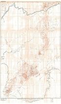
Main Author:
U.S. Geological Survey
Title/Description:
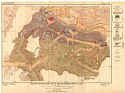
Reconnaissance Map of the Fairbanks Quadrangle, Alaska
Publication Info:
Washington: Department of the Interior, U.S. Geological Survey, 1913; Bulletin 525 Plate 1
Viewing Options
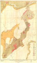
Main Author:
U.S. Geological Survey
Title/Description:
Topographic and Economic Map of the Fairbanks District, Alaska
Publication Info:
Washington: Department of the Interior, U.S. Geological Survey, 1913; Bulletin 525 Plate 2
Viewing Options
Main Author:
U.S. Geological Survey
Title/Description:
Geologic Reconnaissance Map of the Fairbanks Quadrangle, Alaska
Publication Info:
Washington: Department of the Interior, U.S. Geological Survey, 1913; Bulletin 525 Plate 8
Viewing Options
Main Author:
U.S. Geological Survey
Title/Description:
Geologic Map and Sections of the Fairbanks District, Alaska
Publication Info:
Washington: Department of the Interior, U.S. Geological Survey, 1913; Bulletin 525 Plate 11
Viewing Options
Main Author:
U.S. Geological Survey
Title/Description:
Reconnaissance Map of the Noatak-Kobuk Region, Alaska
Publication Info:
Washington: Department of the Interior, U.S. Geological Survey, 1913; Bulletin 536 Plate 1
Viewing Options
Main Author:
U.S. Geological Survey
Title/Description:
Reconnaissance Geologic Map of Noatak-Kubuk Region, Alaska
Publication Info:
Washington: Department of the Interior, U.S. Geological Survey, 1913; Bulletin 536 Plate 2
Viewing Options
Main Author:
U.S. Geological Survey
Title/Description:
Reconnaissance Map of part of Rampart Quadrangle, Alaska
Publication Info:
Washington: Department of the Interior, U.S. Geological Survey, 1913; Bulletin 535 Plate 1
Viewing Options
Main Author:
U.S. Geological Survey
Title/Description:
Geologic Map of part of Rampart Quadrangle, Alaska
Publication Info:
Washington: Department of the Interior, U.S. Geological Survey, 1913; Bulletin 535 Plate 4
Viewing Options
Main Author:
U.S. Geological Survey
Title/Description:
Reconnaissance Map of Yentna District, Alaska
Publication Info:
Washington: Department of the Interior, U.S. Geological Survey, 1913; Bulletin 534 Plate 2
Viewing Options
Main Author:
U.S. Geological Survey
Title/Description:
Geologic Reconnaissance Map of Yentna District, Alaska
Publication Info:
Washington: Department of the Interior, U.S. Geological Survey, 1913; Bulletin 534 Plate 3
Viewing Options
Main Author:
U.S. Geological Survey
Title/Description:
Topographic Map of Nome Quadrangle, Alaska
Publication Info:
Washington: Department of the Interior, U.S. Geological Survey, 1913; Bulletin 533 Plate 1
Viewing Options
Main Author:
U.S. Geological Survey
Title/Description:
Topographic Map of Grand Central Quadrangle, Alaska
Publication Info:
Washington: Department of the Interior, U.S. Geological Survey, 1913; Bulletin 533 Plate 2
Viewing Options
Main Author:
U.S. Geological Survey
Title/Description:
Geologic Map of Nome Quadrangle, Alaska
Publication Info:
Washington: Department of the Interior, U.S. Geological Survey, 1913; Bulletin 533 Plate 3
Viewing Options
Main Author:
U.S. Geological Survey
Title/Description:
Reonnaissance Map of Koyukuk-Chandalar Region, Alaska
Publication Info:
Washington: Department of the Interior, U.S. Geological Survey, 1913; Bulletin 532 Plate 1
Viewing Options
Main Author:
U.S. Geological Survey
Title/Description:
Geologic Reconnaissance Map of Koyukuk-Chandalar Region, Alaska
Publication Info:
Washington: Department of the Interior, U.S. Geological Survey, 1913; Bulletin 532 Plate 5
Viewing Options
Main Author:
U.S. Geological Survey
Title/Description:
Reconnaissance Map of Seward Peninsula Alaska
Publication Info:
Washington: Department of the Interior, U.S. Geological Survey, 1913; Water Supply Paper No. 314 Plate 1
Viewing Options
Title/Description:
Alaska
Publication Info:
Chicago: Rand McNally and Co., 1914; from Commercial Atlas of America
Viewing Options
Main Author:
U.S. Geological Survey
Title/Description:
Reconnaissance Map of the Iditarod - Ruby Region, Alaska
Publication Info:
Washington: Department of the Interior, U.S. Geological Survey, 1914; Bulletin 578, Plate 2
Viewing Options
Main Author:
Reynolds, Francis J.
Title/Description:
Alaska
Publication Info:
New York: P.F. Collier and Son, 1914; from The New Encyclopededic Atlas and Gazatteer of the World
Viewing Options
Main Author:
U.S. Geological Survey
Title/Description:
Geologic Map of Kassan Peninsula, Prince of Wales Island, Alaska
Publication Info:
Washington: U.S. Deparment of the Interior, Geological Survey
Viewing Options
Main Author:
U.S. Geological Survey
Title/Description:
Topographic Map of Kassan Peninsula, Prince of Wales Island, Alaska
Publication Info:
Washington: U.S. Deparment of the Interior, Geological Survey
Viewing Options
Main Author:
U.S. Geological Survey
Title/Description:
Reconnaissance Map of the Middle Kuskokwim and Lower Yukon Region, Alaska
Publication Info:
Washington: Department of the Interior, U.S. Geological Survey, 1914; Bulletin 578 Plate 1
Viewing Options
Main Author:
U.S. Geological Survey
Title/Description:
Reconnaissance Map of the Iditarod-Ruby Region, Alaska
Publication Info:
Washington: Department of the Interior, U.S. Geological Survey, 1914; Bulletin 578 Plate 2
Viewing Options
Main Author:
U.S. Geological Survey
Title/Description:
Geologic Reconnaissance Map of the Iditarod-Ruby Region, Alaska
Publication Info:
Washington: Department of the Interior, U.S. Geological Survey, 1914; Bulletin 578 Plate 3
Viewing Options
Main Author:
U.S. Geological Survey
Title/Description:
Reconnaissance Map of Chitina Quadrangle Copper River Region, Alaska
Publication Info:
Washington: Department of the Interior, U.S. Geological Survey, 1914; Bulletin 576 Plate 1
Viewing Options
Main Author:
U.S. Geological Survey
Title/Description:
Geologic Reconnaissance Map of Hanagita-Bremner Region, Alaska
Publication Info:
Washington: Department of the Interior, U.S. Geological Survey, 1914; Bulletin 576 Plate 2
Viewing Options
Main Author:
U.S. Geological Survey
Title/Description:
Map of Alaska showing distribution of mineral deposits
Publication Info:
Washington: Department of the Interior, U.S. Geological Survey, 1914; Bulletin 592 Plate 1
Viewing Options
Main Author:
U.S. Geological Survey
Title/Description:
Map of Central Alaska, Showing Position of the Coal Fields
Publication Info:
Washington: Department of the Interior, U.S. Geological Survey, 1914; Bulletin 587 Plate 1
Viewing Options
Main Author:
U.S. Geological Survey
Title/Description:
Map of Yukon-Tanana Region Alaska, showing distribution of mineral deposits and location of rainfall and gaging stations
Publication Info:
Washington: Department of the Interior, U.S. Geological Survey, 1914; Water Supply Paper No. 342 Plate 4
Viewing Options
Main Author:
U.S. Geological Survey
Title/Description:
Reconnaissance Map of the Forty mile Quadrangle, Alaska, showing location of rainfall and gaging stations
Publication Info:
Washington: Department of the Interior, U.S. Geological Survey, 1914; Water Supply Paper No. 342 Plate 10
Viewing Options
Main Author:
U.S. Geological Survey
Title/Description:
Reconnaissance Map of the Circle Quadrangle, Alaska, showing location of rainfall and gaging stations
Publication Info:
Washington: Department of the Interior, U.S. Geological Survey, 1914; Water Supply Paper No. 342 Plate 11
Viewing Options
Main Author:
U.S. Geological Survey
Title/Description:
Reconnaissance Map of Fairbanks Quadrangle, Alaska showing location of rainfall and gaging stations
Publication Info:
Washington: Department of the Interior, U.S. Geological Survey, 1914; Water Supply Paper No. 342 Plate 12
Viewing Options
Main Author:
U.S. Geological Survey
Title/Description:
Reconnaissance Map of part of Rampart Quadrangle, Alaska showing locaton of rainfall and gaging stations
Publication Info:
Washington: Department of the Interior, U.S. Geological Survey, 1914; Water Supply Paper No. 342 Plate 13
Viewing Options
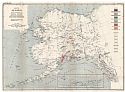
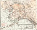
Main Author:
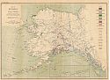
National Geographic Society
Title/Description:
Map of Alaska
Publication Info:
Washington: National Geographic Society, 1914
Viewing Options
Main Author:
U.S.Geological Survey
Title/Description:
Topographic Reconnaissance Map of Kenai Peninsula, Alaska
Publication Info:
Washington: Department of the Interior, U.S. Geological Survey, 1915; Bulletin 587 Plate 2
Viewing Options
Main Author:
U.S. Geological Survey
Title/Description:
Geologic Reconnaissance Map of Kenai Peninsula, Alaska
Publication Info:
Washington: Department of the Interior, U.S. Geological Survey, 1915; Bulletin 587 Plate 3
Viewing Options
Main Author:
U.S. Geological Survey
Title/Description:
Topographic Map of Moose Pass and Vicinity, Kenai Peninsula, Alaska
Publication Info:
Washington: Department of the Interior, U.S. Geological Survey, 1915; Bulletin 587 Plate 4
Viewing Options
Main Author:
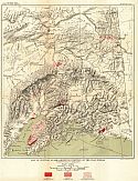
U.S. Geological Survey
Title/Description:
Reconnaissance Map of the Broad Pass Region, Alaska
Publication Info:
Washington: Department of the Interior, U.S. Geological Survey, 1915; Bulletin 608 Plate 1
Viewing Options
Main Author:
U.S. Geological Survey
Title/Description:
Geologic Reconnaissance Map of the Broad Pass Region, Alaska
Publication Info:
Washington: Department of the Interior, U.S. Geological Survey, 1915; Bulletin 608 Plate 2
Viewing Options
Main Author:
U.S. Geological Survey
Title/Description:
Geologic Map of the Willow Creek District, Alaska
Publication Info:
Washington: Department of the Interior, U.S. Geological Survey, 1915; Bulletin 607 Plate 3
Viewing Options
Main Author:
U.S. Geological Survey
Title/Description:
Topographic Map of the Willow Creek District, Alaska
Publication Info:
Washington: Department of the Interior, U.S. Geological Survey, 1915; Bulletin 607 Plate 2
Viewing Options
Main Author:
U.S. Geological Survey
Title/Description:
Geologic Map and Sections of Ellamar District, Prince William Sound, Alaska
Publication Info:
Washington: Department of the Interior, U.S. Geological Survey, 1915; Bulletin 605 Plate 2
Viewing Options
Main Author:
U.S. Geological Survey
Title/Description:
Topographic Map of Ellamar Disrict, Prince William Sound, Alaska
Publication Info:
Washington: Department of the Interior, U.S. Geological Survey, 1915; Bulletin 605 Plate 1
Viewing Options
Main Author:
U.S. Geological Survey
Title/Description:
Map of the Port Valdeg District, Showing Mines and Prospects
Publication Info:
Washington: Department of the Interior, U.S. Geological Survey, 1915; Bulletin 622 Plate 8

Viewing Options
Main Author:
U.S. Geological Survey
Title/Description:
Map Prince William Sound, Showing Mineral Resources
Publication Info:
Washington: Department of the Interior, U.S. Geological Survey, 1915; Bulletin 622 Plate 7
Viewing Options
Main Author:
U.S. Geological Survey
Title/Description:
Geologic Sketch Map of the Welchina-Susitna Region
Publication Info:
Washington: Department of the Interior, U.S. Geological Survey, 1915; Bulletin 622 Plate 6
Viewing Options
Main Author:
U.S. Geological Survey
Title/Description:
Map Showing Mineral Resources of Lower Copper River Region, Alaska
Publication Info:
Washington: Department of the Interior, U.S. Geological Survey, 1915; Bulletin 622 Plate 4

