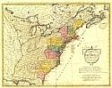
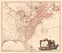
Viewing Options
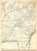
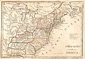
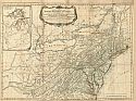
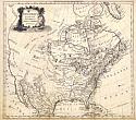
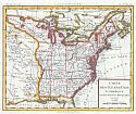
Main Author:
Dunn, Samuel
Title/Description:
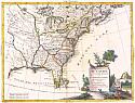
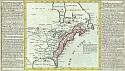
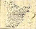
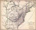
A Map of the British Empire in North America
Publication Info:
London: R. Sayer and J. Bennett, 1776
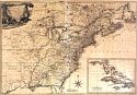
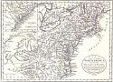
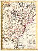
Viewing Options
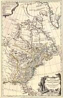
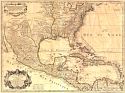
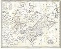
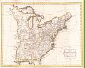
Title/Description:
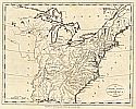
A General Map of North America from the latest observations
Publication Info:
[London: G. Robinson, 1776]
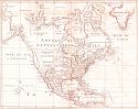
Viewing Options
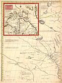
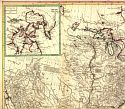
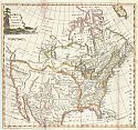
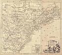
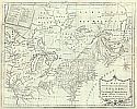
Main Author:
Jefferys, Thomas
Title/Description:
An Accurate Map of North America [Western half of Northern section]
Publication Info:
[London: Sayer and Bennett, 1776]
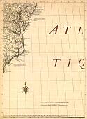
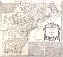
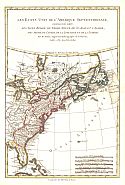
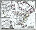
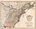
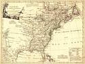
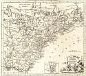
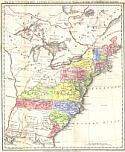
Viewing Options
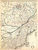
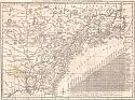
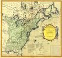
Main Author:
Sayer, Robert and John Bennett
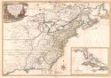
Title/Description:
A general map of the middle British Colonies in America
Publication Info:
London: Sayer and Bennett, 1776
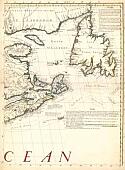
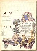
Viewing Options
Main Author:
Homann, Erben
Title/Description:
America Septentrionalis
Publication Info:
Noriebergae: Homannianorum Heredum, 1777
Viewing Options
Main Author:
Imbert, J. Leopold
Title/Description:
Carte des Possessions Angloises dans l'Amerique Septentrionale
Publication Info:
[Paris: 1777]
Viewing Options
Main Author:
Moithey, Maurille Antoine
Title/Description:
Carte Nouvelle des Possessions Angloises en Amerique
Publication Info:
Paris: 1777
Viewing Options
Main Author:
Zatta, Antonio
Title/Description:
Il Canada
Publication Info:
Venezia: Preffo Antonio Zatta, 1778
Viewing Options
Main Author:
DeMaurepas, Jeon-Frederic
Title/Description:
Carte Generale des Colonies Angloises
Publication Info:
Paris: 1778
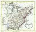
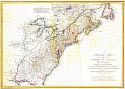
Viewing Options
Main Author:
Kitchin, Thomas
Title/Description:
A New & Accurate Map of North America
Publication Info:
London: 1779
Viewing Options
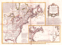
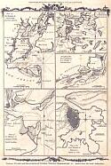
Main Author:
Conder, Thomas
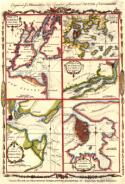
Title/Description:
Various Plans and Draughts of Cities, Towns, and Harbours
Publication Info:
[London: A. Hogg, 1780]; Engraved for Moore's New and Complete Collection of Voyages and Travels
Viewing Options
Main Author:
Conder, Thomas
Title/Description:
North America agreeable to the most approved maps and charts
Publication Info:
[London: A. Hogg, 1780?]; for Moore's New and Complete Collection of Voyages and Travels
Viewing Options
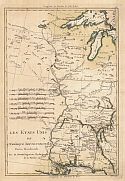
Main Author:
Bonne, Rigobert
Title/Description:
Les Etats Unis de L'Amèrique Septentrionale
Publication Info:
Paris: 1781
Viewing Options
Main Author:
Kitchin, Thomas
Title/Description:
A New Map of the British Empire in North America
Publication Info:
[London: A. Hogg, 1782]; for Millar's New Complete and Universal System of Geography
Viewing Options
Title/Description:
Part of North America
Publication Info:
London: J. Fielding, 1782
Viewing Options
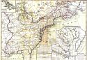
Main Author:
Conder, Thomas
Title/Description:
Various Plans and Draughts of Cities, Towns, Harbors [New York, Boston, Charleston, Philadelphia, and Havana]
Publication Info:
[London: 1782]; for Millar's New Complete Universal System of Geography
Viewing Options
Main Author:
Phelipeau, P.
Title/Description:
Carte Generale des Colonies Angloises dans l'Amerique Septentrionale pour l'Intelligence de la Guerre Presente
Publication Info:
Paris: 1783
Viewing Options
Main Author:
L'Isle, Guillaume de
Title/Description:
Carte du Mexique et des Etats Unis d'Amerique Partie Meridionale
Publication Info:
Paris: d'Auteur, 1783
Viewing Options
Main Author:
Robert de Vaugondy, Giles
Title/Description:
Canada, Louisiane, Possessions Angl
Publication Info:
[Paris: S. Delamarche, 1784]; from his Le Nouvel Atlas por Tatif of 1784
Viewing Options
Main Author:
Gussefeld, Franz Ludwig
Title/Description:
Staaten von Nord America
Publication Info:
modified by Homaennischen Erben
Viewing Options
Main Author:
Lattre, Jean
Title/Description:
Etats-Unis de I'Amerique Sep.le avec le Canada et la Floride
Publication Info:
Paris: Jean Lattre, 1784; from Lattre's Petit Atlas Moderne
Viewing Options
Title/Description:
Amerique Septentrionale
Publication Info:
published in Paris between 1784 and 1800
Viewing Options
Main Author:
Güssefeld, Franz Ludwig
Title/Description:
Charte über die XIII Vereinigte Staaten von Nord-America
Publication Info:
Nuremberg: Heritieres de Homann, 1784
Viewing Options
Main Author:
Brion de la Tour, Louis
Title/Description:
Carte des Etats-Unis d' Amerique et du courss du Mississippi
Publication Info:
Paris: Histoire Universelle, 1784
Viewing Options
Main Author:
Robert de Vaugondy, Giles
Title/Description:
Etats-Unis De L'Amerique Septentrionale
Publication Info:
Paris: Ches Boudet, 1785

Viewing Options
Main Author:
Bowen, Thomas
Title/Description:
A Correct Map fo the United States of North America
Publication Info:
London: 1787, from Bankes's A New and Complete System of Universal Geography
Viewing Options
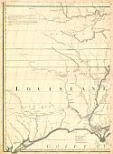
Main Author:
Bonne, Rigobert
Title/Description:
Les Etats Unis de L'Amerique Septentrionale, Parti Occidentale
Publication Info:
Paris: Depot de la Marine, 1788
Viewing Options
Main Author:
Harrison, John after D'Anville
Title/Description:
A Particular Map of The American Lakes, Rivers, etc.
Publication Info:
London: J. Harrison, 1790
Viewing Options
Main Author:
Clouet, Jean Baptiste Louis
Title/Description:
Des possessions Francoises aujourd'hui sous la domination Angloises
Publication Info:
[Paris: 1791]
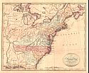
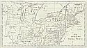
Viewing Options
Title/Description:
A Map of the Northern and Middle States; Comprehending the Western Territory and the British Dominions in North America from the Best Authorities
Publication Info:
London: J. Stockdale, 1792; from Morse's Geography
Viewing Options
Main Author:
Doolittle, Amos
Title/Description:
A Map of the Northern and Middle States: Comprehending the Westtern Territory and the British Dominions in North America. Compiles from the best Authorities
Publication Info:
Boston: Thomas & Andrews, 1793; from Jedediah Morse's American Geography
Viewing Options
Main Author:
Bowles, Carrington
Title/Description:
Bowles's New one-sheet map of the United States of America: with the territories belonging to Great Britain and Spain
Publication Info:
London: Bowles & Carver, 1794
Viewing Options
Main Author:
Russell, John C.
Title/Description:
An Accurate Map of the United States of America
Publication Info:
London: H.D. Symonds, 1794; from Russell's American Atlas of 1795
Viewing Options
Main Author:
Russell, John
Title/Description:
An Accurate Map of the United States of America according to the Treaty of Peace of 1783
Publication Info:
London: H.D. Symond, 1794
Viewing Options
Main Author:
Kitchin, Thomas
Title/Description:
A New Map of the United States of North America
Publication Info:
[London: 1795]; for Baldwin's New Complete & Universal System of Geography
Viewing Options
Title/Description:
A New and Accurate Map of the United States of America
Publication Info:
Edinburgh: Thomas Brown, 1795
Viewing Options
Main Author:
Faden, William
Title/Description:
The United States of North America with the British Territories and those of Spain according to the Treaty of 1784
Publication Info:
London: William Faden, 1796
Viewing Options
Main Author:
Bradley, Abraham, Jr.
Title/Description:
Map of the Northern Part of the United States
Publication Info:
Boston: Thomas & Andrews, 1797; Engraved for Morse's American Gazetteer; 20782
Viewing Options
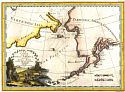
Main Author:
Cassini, Giovanni Maria
Title/Description:
Le Coste Nord Ouest Dell' America Nord Est Dell' Asia
Publication Info:
Rome: 1798
Viewing Options
Main Author:
Phillips, Sir Richard
Title/Description:
Map of the United States, Canada, etc intended to Illustrate the Travels of the Duke de la Rochefoucault Liancourt
Publication Info:
London: R. Phillips, 1799
Viewing Options
Main Author:
Arrowsmith, Aaron
Title/Description:
Die Vereinigten Staaten von Nordamerike
Publication Info:
Nuremberg: 1799
Viewing Options
Title/Description:
The United States of America
Publication Info:
New York: J. Low, 1799; Engraved for Payne's Geography