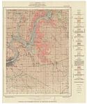
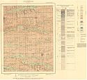
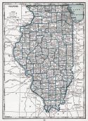
Viewing Options
Main Author:
Illinois State Geological Survey
Title/Description:
General and economic geology of the Dixon quadrangle
Publication Info:
Urbana: Illinois State Geological Survey, 1926; Bulletin 49 Plate 1
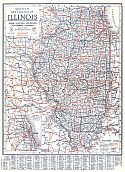
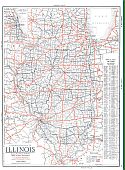
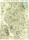
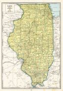
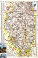
Viewing Options
Main Author:
Clason Map Company
Title/Description:
Best Roads of Illinois
Publication Info:
Chicago: Clason Map Company, c. 1927; from Clason's Touring Atlas
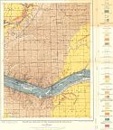
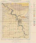
Viewing Options
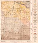
Main Author:
Illinois State Geological Survey
Title/Description:
Economic, structural and surficial geology of the Herscher quadrangle
Publication Info:
Urbana: Illinois State Geological Survey, 1928; Bulletin 55, Plate 1
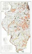
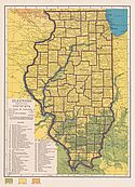
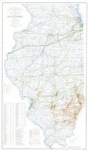
Viewing Options
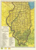
Main Author:
Illinois State Geological Survey
Title/Description:
Drainage Reclamation Map of Illinois
Publication Info:
Urbana: Illinois State Geological Survey, 1929; from Bulletin 42
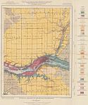
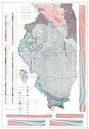
Viewing Options
Main Author:
Illinois State Geological Survey
Title/Description:
Economic and surficial geology of the Alexis quadrangle
Publication Info:
Urbana: Illinois State Geological Survey, 1929; Bulletin 57, Plate 1
Viewing Options
Main Author:
C.S. Hammond and Company
Title/Description:
Illinois
Publication Info:
New York: C.S. Hammond and Company, 1929
Viewing Options
Main Author:
Illinois State Geological Survey
Title/Description:
Topographic Map of Hardin Co. and Adjoining Part of Pope Co., Illinois
Publication Info:
Urbana: Illinois State Geological Survey, 1931; from Bulletin No. 58
Viewing Options
Main Author:
National Map Company
Title/Description:
Illinois
Publication Info:
Indianapolis: National Map Company, 1930; from Official Paved Road and Commercial Survey of the United States
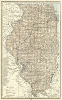
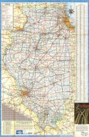
Viewing Options
Main Author:
Clason Map Company
Title/Description:
Clason's Road Map of Illinois
Publication Info:
Denver: The Clason Map Company, 1930; from Clason's Touring Atlas of the United States and Canada
Viewing Options
Main Author:
C.S. Hammond and Company
Title/Description:
Illinois
Publication Info:
New York: C.S. Hammond and Company, c. 1930; from The New World Loose Leaf Atlas, Sixth Edition
Viewing Options
Main Author:
C.S. Hammond and Company
Title/Description:
Illionois
Publication Info:
New York: C.S. Hammond and Company, c. 1930; from The New World Loose Leaf Atlas, Sixth Edition
Viewing Options
Main Author:
Geographical Publishing Company
Title/Description:
Illinois
Publication Info:
Chicago: Geographical Publishing Company1931; from Commercial Atlas of the World
Viewing Options
Main Author:
Branom, Frederick K. and Lloyd Edwin Smith
Title/Description:
Illinois
Publication Info:
Chicago: Geographical Publishing Company, 1936; from Capper's 1936 Atlas of the World
Viewing Options
Main Author:
Rand McNally and Company
Title/Description:
Standard Map of Illinois
Publication Info:
Chicago: Rand McNally and Company, 1936
Viewing Options
Main Author:
Willman, H.B.
Title/Description:
Surficial geology of the Marseilles quadrangle
Publication Info:
Urbana: Illinois State Geological Survey, 1942; Bulletin 66, Plate 1
Viewing Options
Main Author:
William, H.B.
Title/Description:
Surficial geology of the Ottawa quadrangle
Publication Info:
Urbana: Illinois State Geological Survey, 1942; Bulletin 66, Plate 2
Viewing Options
Main Author:
Geographical Publishing Company
Title/Description:
Illinois
Publication Info:
Chicago: Geographical Publishing Company, 1942; from The New International Atlas of the World, War Edition
Viewing Options
Main Author:
Robinson, L.C. and H.B. Willman
Title/Description:
Surficial geology of the Streator quadrangle
Publication Info:
Urbana: Illinois State Geological Survey, 1942; Bulletin 66, Plate 3
Viewing Options
Main Author:
Bell, Alfred H. and David H. Swann
Title/Description:
Oil and Gas Map of Illinois
Publication Info:
(Illinois) State Geological Survey, 1945
Viewing Options
Main Author:
Illinois State Geological Survey
Title/Description:
Geologic Map of Illinois
Publication Info:
Urbana: Illinois State Geological Survey, 1945
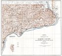
Viewing Options
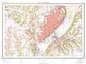
Main Author:
U.S. Geological Survey
Title/Description:
Peoria and Vicinity
Publication Info:
Washington D.C.: Department of the Interior, U.S. Geological Survey, 1949
Viewing Options
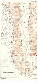
Main Author:
U.S. Geological Survey
Title/Description:
Structure Contour Map of Hardin and Brussels Quadrangles, Illinois
Publication Info:
Washington, D.C.: Department of the Interior, U.S. Geologic Survey, 1951; Professional Paper 218, Plate 2
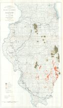
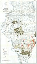
Viewing Options
Title/Description:
Minable Coal Reserves of Illinois as of 1950, No. 7 Coal Bed
Publication Info:
Urbana: State Geological Survey, 1952; Bulletin No. 78, Plate 1
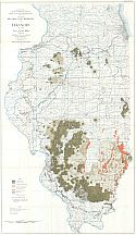
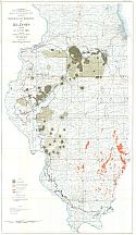
Viewing Options
Title/Description:
Minable Coal Reserves of Illinois as of 1950, No. 6 Coal Bed
Publication Info:
Urbana: State Geological Survey, 1952; Bulletin No. 78, Plate 2
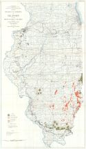
Viewing Options
Title/Description:
Minable Coal Reserves of Illinois as of 1950, No. 5 Coal Bed
Publication Info:
Urbana: State Geological Survey, 1952; Bulletin No. 78, Plate 3
Viewing Options
Title/Description:
Minable Coal Reserves of Illinois as of 1950, No. 2 Coal Bed
Publication Info:
Urbana: State Geological Survey, 1952; Bulletin No. 78, Plate 4
Viewing Options
Title/Description:
Minable Coal Reserves of Illinios as of 1950, Miscellaneous Coal Beds
Publication Info:
Urbana: State Geological Survey, 1952; Bulletin No. 78, Plate 5
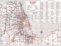
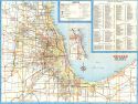
Viewing Options
Main Author:
State of Illinois
Title/Description:
Chicago and Vicinity
Publication Info:
[Springfield]: The State of Illinois, 1953
Viewing Options
Main Author:
State of Illinois
Title/Description:
Illinois Official Highway Map
Publication Info:
[Springfield]: The State of Illinois, 1953
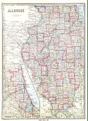
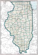
Viewing Options
Main Author:
State of Illinois
Title/Description:
Illinois
Publication Info:
[Springfield]: The State of Illinois, 1963
Viewing Options
Main Author:
State of Illinois
Title/Description:
Chicago and Vicinity
Publication Info:
[Springfield]: The State of Illinois, 1963
Viewing Options
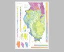
Main Author:
Illinois State Geological Survey
Title/Description:
Geological Map of Illinois
Publication Info:
Urbana: Geological Survey of Illinois, 1967
Original Source:
Geological Survey of Alabama

