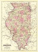
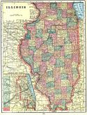
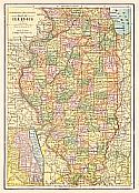
Viewing Options
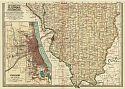
Main Author:
Johnson, Alvin J.
Title/Description:
Illinois
Publication Info:
New York: 1896 from the 1896 Johnson's Universal Encyclopedia
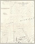
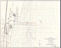
Viewing Options
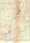
Main Author:
U.S. Army Corps of Engineers
Title/Description:
Map of Calumet Harbor, Illinois showing proposed harbor of refuge
Publication Info:
Washington: U.S. House of Representatives, 54th Congress, 1st Session, Doc. No. 277, 1896
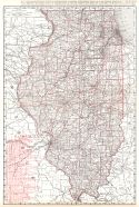
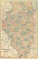
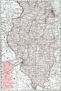
Viewing Options
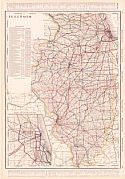
Main Author:
Rand McNally and Company
Title/Description:
Illinois
Publication Info:
Chicago: Rand McNally and Company, 1896; from Enlarged Business Atlas
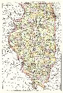
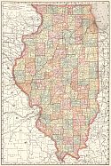
Viewing Options
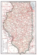
Main Author:
Rand McNally and Company
Title/Description:
Illinois
Publication Info:
Chicago: Rand McNally and Company,1896; from Indexed Atlas of the World
Viewing Options
Main Author:
Cram, George F.
Title/Description:
Illinois from Cram's Universal Atlas, Geographical, Astronomical and Historical
Publication Info:
Chicago: George F. Cram, 1898
Viewing Options
Main Author:
Mast, Crowell and Kirkpatrick
Title/Description:
Map of Illinois
Publication Info:
Springfield, Ohio: Mast, Crowell, and Kirkpatrick, 1898
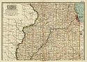
Viewing Options
Main Author:
Rand McNally and Company
Title/Description:
Illinois
Publication Info:
Chicago: Rand McNally and Company, 1898; from the Indexed Atlas of the World
Viewing Options
Viewing Options
Main Author:
Smith, Benjamin E.
Title/Description:
Illinois
Publication Info:
New York: The Century Company, 1899; from The Century Atlas of the World
Viewing Options
Main Author:
Cram, George F.
Title/Description:
Illinois
Publication Info:
Chicago: George F. Cram, 1899; from The Standard American Railway System Atlas
Viewing Options
Main Author:
U.S. Geological Survey
Title/Description:
Topographic Map Showing Drainage features near Fulton, Illinois and vicinity of the upper rapids of the Mississppi River
Publication Info:
Washington: Department of the Interior, U.S. Geological Survey, 1899; Monograph 38 Plate 18
Viewing Options
Main Author:
The Bradstreet Company
Title/Description:
Illinois
Publication Info:
New York: The Bradstreet Company, 1899; from Bradstreet's Pocket Atlas of the United States
Viewing Options
Main Author:
Servoss, R.D.
Title/Description:
Railroad and County Map of Illinois
Publication Info:
New York: The Snow-Church Surtey Co., 1900
Viewing Options
Main Author:
Rand McNally & Company
Title/Description:
Illinois Railroads
Publication Info:
Chicaco: Rand McNally & Company, 1900
Viewing Options
Main Author:
U.S. Army Corps of Engineers
Title/Description:
Map of Waukegan Harbor, III.
Publication Info:
Washington: U.S. House of Representatives, 56th Congress, 1st Session, Doc. No. 343, 1900

