
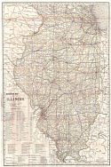
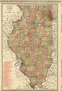
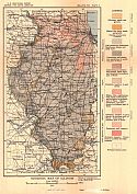
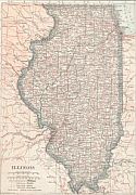
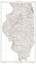
Viewing Options
Main Author:
(Illinios) State Geological Survey
Title/Description:
Base Map of Illinois
Publication Info:
(Illinois) State Geological Survey, 1911
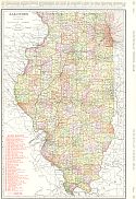
Viewing Options
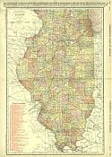
Main Author:
Rand McNally & Co.
Title/Description:
Railroad Map of Illinois
Publication Info:
Chicago: Rand McNally & Co, 1911; from Rand McNally & Co.'s New Business Atlas Map of Illinois
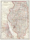
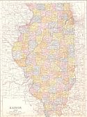
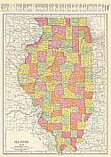
Viewing Options
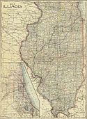
Main Author:
Rand McNally and Company
Title/Description:
Illinois
Publication Info:
Chicago: Rand McNally and Company, 1911; from the Commercial Atlas of America
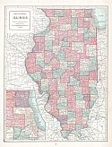
Viewing Options
Main Author:
Cram, George F.
Title/Description:
Illinois
Publication Info:
Chicago: George F. Cram, 1911; from Cram's Unrivaled Atlas of the World
Viewing Options
Main Author:
Ravenstein, E.G.
Title/Description:
Illinois
Publication Info:
Chicago: The Reilly and Britton Company, 1911; from The New Census Atlas of the World
Viewing Options
Main Author:
Rand McNally and Co.
Title/Description:
Illinois
Publication Info:
Chicago: Rand McNally and Co., 1912; from the Library Atlas of the World

Viewing Options
Title/Description:
Geological Map, Part of Southwestern Illinois
Publication Info:
Urbana: Illinois State Geological Survey, 1912; from Bulletin No. 20, Plate 2

Viewing Options
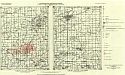
Main Author:
Kay, Fred H.
Title/Description:
Map of Carlinville Oil Field
Publication Info:
Urbana: Illinois State Geological Survey, 1912; from Bulletin 20, Plate 8
Viewing Options
Main Author:
Rand McNally and Company
Title/Description:
Illinois
Publication Info:
Chicago: Rand McNally and Company, 1912; from The Rand McNally Imperial Atlas of the World
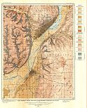
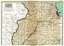
Viewing Options
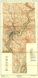
Main Author:
U.S. Geological Survey
Title/Description:
Map Showing Areal Geology of the Peoria Quadrangle, Illinois
Publication Info:
Washington: Department of the Interior, U.S. Geological Survey, 1912; Bulletin 506 Plate I
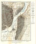
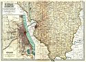
Viewing Options
Main Author:
U.S. Geological Survey
Title/Description:
Map Showing Economic Geology of the Peoria Quadrangle, Illinois
Publication Info:
Washington: Department of the Interior, U.S. Geological Survey, 1912; Bulletin 506 Plate II
Viewing Options
Main Author:
U.S. Geological Survey
Title/Description:
Geologic Map of Illinois
Publication Info:
Washington: Department of the Interior, U.S. Geological Survey, 1912; Bulletin 522 Plate V
Viewing Options
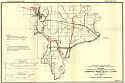
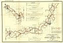
Main Author:
Rand McNally & Company
Title/Description:
Rand McNally and Co.'s New 11 x 14 Map of Illinois
Publication Info:
Chicago: Rand McNally & Co., 1913; from the Rand McNally Banker's Directory and List of Annorneys, 76th Edition
Northern Half
Southern Half
Main Author:
The Century Company
Title/Description:
Illinois, Northern Part
Publication Info:
New York: The Century Company, 1913; from The Century Atlas of the World
Index Map
Map 2

Map 3
Map 4
Map 5
Map 6
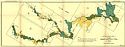
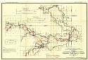
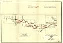
Main Author:
Harman, Jacob A.
Title/Description:
Plans for Reclamation of Lands Subject to Overflow in the Embarras River Valley, Illinois - Index Map
Publication Info:
Urbana: Illinois State Geological Survey, 1913; Bulletin 25 Plate 1
Viewing Options
Main Author:
Cram, George F.
Title/Description:
Illinois
Publication Info:
Chicago: George F. Cram, 1913; from Cram's Unrivaled Atlas of the World
Viewing Options
Main Author:
Rand McNally and Co.
Title/Description:
Illinois
Publication Info:
Chicago: Rand McNally and Co., 1914; from Commercial Atlas of America
Viewing Options
Main Author:
Illinois State Geological Survey
Title/Description:
Elizabeth Sheet of the Lead and Zinc District
Publication Info:
Urbana: Illinois State Geological Survey, 1914; from Bulletin 21, Plate 22
Viewing Options
Main Author:
Illinois State Geological Survey
Title/Description:
Galena Sheet of the Lead and Zinc District
Publication Info:
Urbana: Illinois State Geological Survey, 1914; from Bulletin 21, Place 20
Viewing Options
Main Author:
Illinois State Geological Survey
Title/Description:
Geological Map of Galena and Elizabeth Quadrangles
Publication Info:
Urbana: Illinois State Geological Survey, 1914; from Bulletin 21 Plate 19
Viewing Options
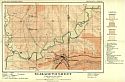
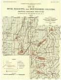
Main Author:
Kay, F.H. and K.D. White
Title/Description:
Map of Bond, Macoupin and Montgomery Counties Showing Geologic Structure
Publication Info:
Urbana: Illinois State Geological Survey, 1914; from Bulletin 28, Plate 2
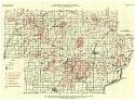
Viewing Options
Main Author:
Morse, William C. and John L. Rich
Title/Description:
Map of Parts of Schuyler, Brown, Adams and Hancock Counties showing Position of Underlying Beds by means of Contours on coal No. 2
Publication Info:
Urbana: Illinois State Geological Survey, 1914; from Bulletin 31, plate 1
Viewing Options
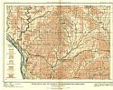
Main Author:
Illinois State Geological Survey
Title/Description:
Map of Colchester - Macomb Quadrangles
Publication Info:
Urbana: Illinois State Geological Survey, 1914; from Bulletin 31, Plate 3
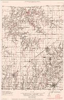
Viewing Options
Main Author:
Illinois State Geological Survey
Title/Description:
Topography and Geologic Structure, Gillespie quadrangle
Publication Info:
Urbana: Illinois State Geological Survey, 1914; Bulletin 31, Plate 9
Viewing Options
Main Author:
Illinois State Geological Survey
Title/Description:
Topography and Geologic Structure, Mount Olive quadrangle
Publication Info:
Urbana: Illinois State Geological Survey, 1914; Bulletin 31, Plate 10
Viewing Options
Main Author:
Reynolds, Francis J.
Title/Description:
Illinois
Publication Info:
New York: P.F. Collier and Son, 1914; from The New Encyclopedic Atlas and Gazatteer of the World
Viewing Options
Main Author:
U.S. Geological Survey
Title/Description:
State of Illinois
Publication Info:
Washington D.C.: Department of the Interior, U.S. Geological Survey, 1915; compiled 1909-1910, reprinted 1943

Viewing Options
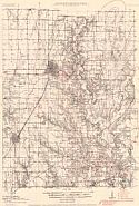
Main Author:
Illinois State Geological Survey
Title/Description:
Map showing geologic structure of the Springfield quadrangle
Publication Info:
Urbana: Illinois State Geological Survey, 1915; Bulletin 20, Plate 11

