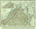
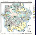
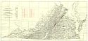
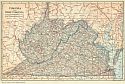
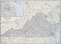
Viewing Options
Main Author:
Rand McNally and Company
Title/Description:
Virginia
Publication Info:
Chicago: Rand McNally and Co., 1916; from The Ideal Atlas of the World
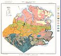
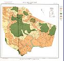
Viewing Options
Main Author:
Bonsteel, J.A.
Title/Description:
Diamond Springs Sheet, Soil and Crop Map, November, 1915 (Virginia Beach)
Publication Info:
Washington: U.S. Department of Agriculture, Bureau of Soils, 1916; from Bulletin 1005
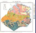
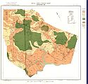
Viewing Options
Main Author:
Bonsteel, J.A.
Title/Description:
Diamond Springs Sheet, Soil and Crop Map, June 1916 (Virginia Beach)
Publication Info:
Washington: U.S. Department of Agriculture, Bureau of Soils, 1916; from Bulletin 1005
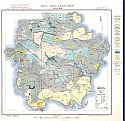
Viewing Options
Main Author:
Bonsteel, J.A.
Title/Description:
Churchland Sheet, Soil and Crop Map, June 1916 (Portsmouth)
Publication Info:
Washington: U.S. Department of Agriculture, Bureau of Soils, 1916; from Bulletin 1005
Viewing Options
Main Author:
Bonsteel, J.A.
Title/Description:
Churchland Sheet, Soil and Crop Map, August 1916 (Portsmouth)
Publication Info:
Washington: U.S. Department of Agriculture, Bureau of Soils, 1916; from Bulletin 1005
Viewing Options
Main Author:
Bonsteel, J.A.
Title/Description:
Onley Sheet, Soil and Crop Map, July 1916 (Accomack Co.)
Publication Info:
Washington: U.S. Department of Agriculture, Bureau of Soils, 1916; from Bulletin 1005
Viewing Options
Main Author:
Bonsteel, J.A.
Title/Description:
Onley Sheet, Soil and Crop Map, September 1916 (Accomack Co.)
Publication Info:
Washington: U.S. Department of Agriculture, Bureau of Soils, 1916; from Bulletin 1005
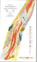
Viewing Options
Main Author:
Virginia Geological Survey and the North Carolina Geological and Economic Survey
Title/Description:
Geological Map of Virgilina District of Virginia and North Carolina
Publication Info:
Baltimore: A. Hoen and Company, 1917
Viewing Options
Main Author:
Virginia Geological Survey
Title/Description:
Geological Map of the Crystalline Region of Virginia showing Clay Localities
Publication Info:
Charlottesville: Virginia Geological Survey, 1917; Bulletin XIII, Plate 1
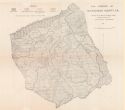
Viewing Options
Title/Description:
The Forests of Dickenson County, Virginia
Publication Info:
Charlottesville: Office of the State Forester, 1917; Bulletin No. 17
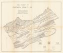
Viewing Options
Main Author:
Schwab, W.G.
Title/Description:
The Forests of Tazewell County, Va.
Publication Info:
Charlottesville: Office of the State Forester, 1917; Bulletin No. 18
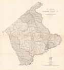
Viewing Options
Main Author:
Schwab, W.G.
Title/Description:
The Forests of Buchanan County, VA
Publication Info:
Charlottesville: Office of the State Forester, 1917; Bulletin No. 16
Viewing Options
Main Author:
Virginia Geological Survey
Title/Description:
A Geologic and Economic Map of the Coal-Bearing Part of Tazewell County, Virginia
Publication Info:
Charlottesville: Virginia Geological Survey, 1918; Bulletin IX, Plate II
Viewing Options
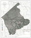
Main Author:
Virginia Geological Survey
Title/Description:
Topographic Map of the Coal-Bearing Part of Tazewell County, Virginia
Publication Info:
Charlottesville: Virginia Geological Survey, 1918
Viewing Options
Main Author:
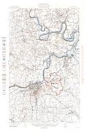
U.S. Geological Survey
Title/Description:
Camp Lee Quadrangle, Virginia
Publication Info:
Washington: Department of the Interior, U.S. Geological Survey, 1918
Viewing Options
Main Author:
Hinds, Henry et.al.
Title/Description:
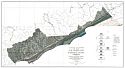
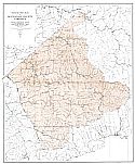
Geologic Map of Buchanon County, Virginia
Publication Info:
Charlottesville: Virginia Geological Survey, 1918; Bulletin XVIII, Plate II
Viewing Options
Main Author:
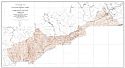
Virginia Geological Survey
Title/Description:
Topographic Map of Buchanon County, Virginia
Publication Info:
Charlottesville: Virginia Geological Survey, 1918; Bulletin XVII, Plate I
Viewing Options
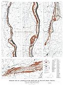
Main Author:
Virginia Geological Survey
Title/Description:
Geologic Map of a Portion of the West Foot of the Blue Ridge, Virginia
Publication Info:
Charlottesville: Virginia Geological Survey, 1918; Bulletin XVII, Plate III
Viewing Options
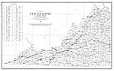
Main Author:
Ries, H. and Somers, R.E.
Title/Description:
Map Showing City Localities in Western Virginia
Publication Info:
Charlottesville: Virginia Geological Survey, 1920
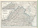
Viewing Options
Main Author:
Reynolds, Francis J.
Title/Description:
Virginia and West Virginia
Publication Info:
New York: P.F. Collier and Son Company, 1920; from The New World Atlas and Gazetteer
Viewing Options
Main Author:
Cram, George F.
Title/Description:
Virginia
Publication Info:
Chicago: James R. Gray and Company, 1920; from Cram's Unrivaled Atlas of the World
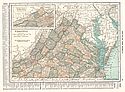
Viewing Options
Main Author:
C.S. Hammond and Company
Title/Description:
Virginia
Publication Info:
New York: C.S. Hammond and Company, 1920; from The New Reference Atlas of the World
Original Source:
Courtesy of Shawn Carter
Viewing Options
Main Author:
Leslie-Judge Company
Title/Description:
Virginia
Publication Info:
New York: Leslie-Judge Company1920; from Leslie's New World Atlas