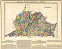
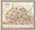
Viewing Options
Title/Description:
Geographical, Statistical, and Historical Map of Virginia
Publication Info:
Philadelphia: Carey & Lea, 1822. From Carey & Lea's American Atlas of 1822
Viewing Options
Main Author:
Bradford, Thomas Gamaliel
Title/Description:
Virginia, Maryland, and Delaware
Publication Info:
Unknown Publication

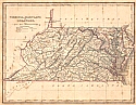
Viewing Options
Main Author:
Bradford, Thomas Gamaliel
Title/Description:
Virginia
Publication Info:
Boston: 1838
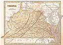
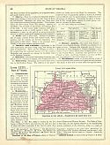
Viewing Options
Main Author:
Morse, Sidney E.
Title/Description:
Virginia
Publication Info:
New York: Harper and Brothers, 1844; from the System of Geography for the Use of Schools
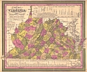
Viewing Options
Main Author:
Mitchell, Samuel Augustus
Title/Description:
A New Map of Virginia with its Canals, Roads, and Distances
Publication Info:
Philadelphia: S.A. Mitchell, 1847
Viewing Options
Main Author:
Thomas Cowperthwait and Company
Title/Description:
A New Map of Virginia with its Canals, Roads, and Distances
Publication Info:
Philadelphia: Thomas Cowperthwait & Co., 1850
Viewing Options
Main Author:
Goodrich, S.G.
Title/Description:
Virginia
Publication Info:
New York: George Savage, 1850; from A Comprehensive Geography and History Ancient and Modern