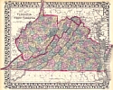
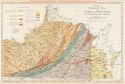
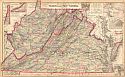
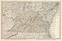
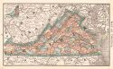
Viewing Options
Main Author:
Mitchell, Samuel Augustus
Title/Description:
County Map of Virginia and West Virginia
Publication Info:
Philadelphia: S.A. Mitchell, 1876
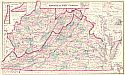
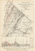
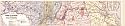
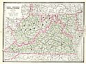
Viewing Options
Main Author:
Gray, Frank A.
Title/Description:
Gray's New Topographical Map of Virginia and West Virginia
Publication Info:
Philadelphia: O.W. Gray & Son, 1877
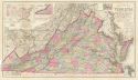
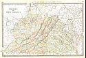
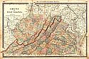
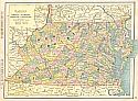
Viewing Options
Main Author:
Gray, Frank A.
Title/Description:
Grays New Map of Virginia
Publication Info:
Philadelphia: O.W. Gray and Son, 1879; prepared for the Virginia Department of Agriculture
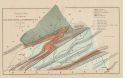
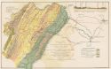
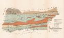
Viewing Options
Main Author:
Stevenson, J.J.
Title/Description:
Geological Map of parts of Lee, Wise, Scott and Washington Cos., Virginia
Publication Info:
Staunton: The Virginias, Vol. II. No 2, January 1881
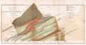
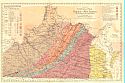
Viewing Options
Main Author:
Hotchkiss, Jed
Title/Description:
Map showing Proposed Routes of the Richmond and Southwestern Railway
Publication Info:
Staunton: The Virginias, Vol. I, No. 6, June 1880; printed on an earlier geologic map by William Rogers
Viewing Options
Main Author:
Hotchkiss, Jed
Title/Description:
Topographical Map of Brock's Gap and Vicinity, Rockingham Co., Va.
Publication Info:
Staunton: The Virginias, Vol. 1 No. 9, September 1880
Viewing Options
Main Author:
Stevenson, J.J.
Title/Description:
Geological Map of Parts of Lee, Wise, Scott and Washington Cos., Virginia
Publication Info:
Philadelphia: Proceeding of the American Philisophical Society, January 21, 1881
Viewing Options
Main Author:
Rand McNally and Company
Title/Description:
Virginia and West Virginia
Publication Info:
Chicago: Rand McNally and Company, 1881; from New Indexed Business Atlas and Shippers Guide
Viewing Options
Main Author:
Hotchkiss, Jed
Title/Description:
Geological Map of the Potomac Basin West of the Blue Ridge, Virginia and West Virgnina showing the relations of its Upper Potomac Coal Basin and Iron-Ore Bearing Areas
Publication Info:
Staunton: The Virginias, Vol 3, No 5, May 1882
Viewing Options
Main Author:
Hardesty, H.H.
Title/Description:
Map of Virginia and West Virginia
Publication Info:
New York: H.H. Hardesty & Co., 1883; from Hardesty's Historical and Geographical Encyclopedia
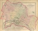
Viewing Options
Main Author:
O.W. Gray and Son
Title/Description:
Richmond, Henrico County, Virginia
Publication Info:
Philadelphia: O.W. Gray and Son, 1883; from The National Atlas
Viewing Options
Main Author:
O.W. Gray and Son
Title/Description:
Virginia and West Virginia
Publication Info:
Philadelphia: O.W. Gray and Son, 1883; from The National Atlas
Viewing Options
Main Author:
Watson, Gaylord
Title/Description:
Virginia, West Virginia
Publication Info:
Boston: Perry and Spaulding, 1883; from New Indexed Family Atlas of the United States with Maps of the World
Viewing Options
Main Author:
Campbell, J.L.
Title/Description:
A Map of the Richmond and Alleghany Railroad, Showing Its Connections and Chief Mineral Resources
Publication Info:
RichmondL A. Hoen and Company, 1884; to accompany Report on the Geology and Mineral Resources of the James River Valley
Viewing Options
Main Author:
Stevenson, J.J.
Title/Description:
Geological Map of Russell, Tazewell Counties with Parts of Wise, Washington, and Smyth Cos. Virginia
Publication Info:
Philadelphia: Proceedings of the American Philosophical Society, November 21, 1884
Viewing Options
Main Author:
Rogers, W.B.
Title/Description:
Hotchkiss Geologic Map of Virginia and West Virginia
Publication Info:
New York: D. Appleton and Company, 1884; reprint of annual report and other papers on the geology of Virginia
Viewing Options
Main Author:
Rand McNally and Company
Title/Description:
Virginia
Publication Info:
Chicago: Rand McNally and Company, 1884; from The New Household Atlas of the World
Viewing Options
Main Author:
Cram, George F.
Title/Description:
Virginia, West Virginia, Maryland, and Delaware
Publication Info:
Chicago: George F. Cram, 1885
Viewing Options
Main Author:
Cram, George F.
Title/Description:
Watson's Atlas Map of Virginia, W. Virginia, Maryland and Delaware
Publication Info:
Chicago: Gaylord Watson, 1885; from Watson's New and Complete Illustrated Atlas of the World