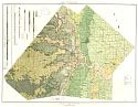
Viewing Options
Main Author:
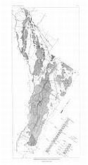
Sullivan, Vernon L.
Title/Description:
Map of Pecos County, Texas
Publication Info:
El Paso: Vernon L. Sullivan, c.1926
Viewing Options
Main Author:
Baker, Charles Laurence
Title/Description:
Exploratory Geologic Map of a Part of Trans-Pecos TX
Publication Info:
Austin: University of Texas Bureau of Economic Geology, 1927; Map 1 Bulletin No. 2745

Viewing Options
Main Author:
Clason Map Company
Title/Description:
Best Roads of Texas
Publication Info:
Chicago: Clason Map Company, c. 1927; from Clason's Touring Atlas
Viewing Options
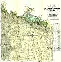
Main Author:
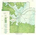
University of Texas, Bureau of Economic Geology
Title/Description:
Geologic Map of Tom Green Co.
Publication Info:
Austin: University of Texas Bureau of Economic Geology, 1928; Map 8 Bulletin No. 2807
Viewing Options
Main Author:
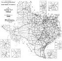
Texas State Highway Commission
Title/Description:
Official Highway Map of Texas
Publication Info:
Austin: The Commission, 1929
Viewing Options
Main Author:
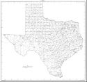
U.S. Department of Commerce, Bureau of the Census
Title/Description:
Texas Minor Civil Divisions
Publication Info:
Washington: U.S. Government Printing Office, c1930
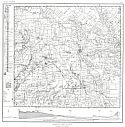
Viewing Options
Main Author:
Adkins, W.S. and M.B. Arick
Title/Description:
Geologic Map of Bell Co., TX
Publication Info:
University of Texas Bureau of Economic Geology, 1930; Map 1 Bulletin No. 3016

Viewing Options
Main Author:
National Map Company
Title/Description:
Texas - West
Publication Info:
Indianapolis: National Map Company, 1930; from Official Paved Road and Commercial Survey of the United States

Viewing Options
Main Author:
National Map Company
Title/Description:
Texas - East
Publication Info:
Indianapolis: National Map Company, 1930; from Official Paved Road and Commercial Survey of the United States

Viewing Options
Main Author:
Clason Map Company
Title/Description:
Clason's Road Map of Texas
Publication Info:
Denver: The Clason Map Company, 1930; from Clason's Touring Atlas of the United States and Canada

Viewing Options
Main Author:
C.S. Hammond and Company
Title/Description:
Texas (Western Part)
Publication Info:
New York: C.S. Hammond and Company, c. 1930; from The New World Loose Leaf Atlas, Sixth Edition

Viewing Options
Main Author:
C.S. Hammond and Company
Title/Description:
Texas (Eastern Part)
Publication Info:
New York: C.S. Hammond and Company, c. 1930; from The New World Loose Leaf Atlas, Sixth Edition

Viewing Options
Main Author:
C.S. Hammond and Company
Publication Info:
New York: C.S. Hammond and Company, c. 1930; from The New World Loose Leaf Atlas, Sixth Edition
Viewing Options
Main Author:
Bullard, Fred M.
Title/Description:
Geologic Map of Grayson Co., TX
Publication Info:
Austin: University of Texas Bureau of Economic Geology, 1931

Viewing Options
Main Author:
Geographical Publishing Company
Publication Info:
Chicago: Geographical Publishing Company1931; from Commercial Atlas of the World
Viewing Options
Main Author:
Scott, Gayle and J.M. Armstrong
Title/Description:
Geologic Map of Wise Co. TX
Publication Info:
Austin: University of Texas Bureau of Economic Geology, 1932; from Bulletin 3224

Viewing Options
Main Author:
U.S. Geological Survey
Title/Description:
Geologic Map of the Lower Rio Grande Region, Texas
Publication Info:
Washington: Department of the Interior, U.S. Geological Survey, 1932; Bulletin 837, Plate 7

Viewing Options
Main Author:
Reed, Lyman C. and Oscar M. Longnecker, Jr.
Title/Description:
Geologic Map of Hemphill County, Texas
Publication Info:
Austin: University of Texas, Bureau of Economic Geology, 1932; from Bulletin No 3231

Viewing Options
Main Author:
Continental Oil Company
Title/Description:
Official Road Map of Texas
Publication Info:
Chicago: H.M. Gousha Company, 1932
Original Source:
Murray Hudson
Viewing Options
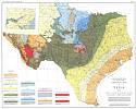
Main Author:
University of Texas, Bureau of Economic Geology
Title/Description:
Geologic Map of Texas
Publication Info:
The University of Texas, Bureau of Economic Geology from Part 5 of Volume 1 of the Geology of Texas

Viewing Options
Main Author:
Continental Oil Company
Publication Info:
Chicago: H.M. Gousha Company, 1934
Original Source:
Murray Hudson

Viewing Options
Main Author:
U.S. Geological Survey
Title/Description:
Map of Atascosa and Frio Counties Showing the Depth to the Carrizo Sand and the Height Above Sea Level to Which Water from the Carrizo Sand Would Rise in 1930
Publication Info:
Washington: Department of the Interior, U.S. Geological Survey, 1935; Water Supply Paper No. 676 Plate 2

Viewing Options
Main Author:
U.S. Geological Survey
Title/Description:
Geologic Map of Atascosa and Frio Counties, Texas, Showing Limits of the Area of Artesian Flow, Irrigated Lands and Location of Record Wells
Publication Info:
Washington: Department of the Interior, U.S. Geological Survey, 1935; Water Supply Paper No. 676 Plate 1