Viewing Options
Viewing Options
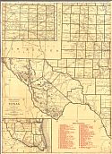
Main Author:
Rand McNally and Company
Publication Info:
Chicago: Rand McNally and Company, 1921; from The Commercial Atlas of America
Viewing Options
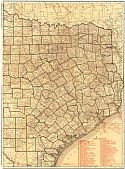
Main Author:
Rand McNally and Company
Title/Description:
Texas- Black and White Mileage Chart
Publication Info:
Chicago: Rand McNally and Company, 1921; from The Commercial Atlas of America

Viewing Options
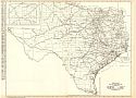
Main Author:
Cram, George F.
Title/Description:
Map of Texas - Western
Publication Info:
Chicago: George F. Cram Company, 1921; from Cram's Unrivaled Atlas of the World

Viewing Options
Main Author:
Cram, George F.
Title/Description:
Map of Texas - Eastern
Publication Info:
Chicago: George F. Cram Company, 1921; from Cram's Unrivaled Atlas of the World
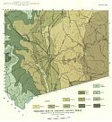
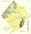
Viewing Options
Main Author:
Winton, H.T.
Title/Description:
Geologic Map of Johnson Co., TX
Publication Info:
Austin: University of Texas Bureau of Economic Geology, 1922; Map 1 Bulletin No. 2229

Viewing Options

Viewing Options
Main Author:
C.S. Hammond
Publication Info:
New York: C.S. Hammond and Company, 1922; from The New World Looseleaf Atlas

Viewing Options
Main Author:
U.S. Geological Survey
Title/Description:
Geologic Map of the Gulf Coastal Plain of Texas Adjacent to the Rio Grande
Publication Info:
Washington: U.S. Deparment of the Interior, Geological Survey

Viewing Options
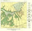
Main Author:
U.S. Geological Survey
Title/Description:
Map of Ranger Oil Field and Vicinity, Eastland County, Texas Showing Oil and Gas Wells, Structure of Surface Rocks and Outcrop of Key Beds
Publication Info:
Washington: Department of the Interior, U.S. Geological Survey, 1922; Bulletin 736 Plate 17

Viewing Options
Main Author:
U.S. Geological Survey
Title/Description:
Map Showing Geologic Structure of the Wiles Area, Ranger District, Stephens County, Texas
Publication Info:
Washington: Department of the Interior, U.S. Geological Survey, 1922; Bulletin 736 Plate 8
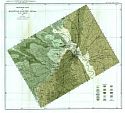
Viewing Options
Main Author:
Bailey, Thomas L.
Title/Description:
Geologic Map of Colorado Co., TX
Publication Info:
Austin: University of Texas Bureau of Economic Geology, 1923; Map 1 Bulletin No. 2333
Viewing Options
Main Author:
Patton, Leroy, T.
Title/Description:
Geologic Map of Potter Co., TX
Publication Info:
Austin: University of Texas Bureau of Economic Geology, 1923; Map 1 Bulletin No. 2330

Viewing Options
Main Author:
U.S. Geological Survey
Title/Description:
Geologic Map and Sections of the Coastal Plain of Texas West of the Brazos River
Publication Info:
Washington: Deparment of the Interior, U.S. Geological Survey
Viewing Options
Main Author:
Adkins, W.R.
Title/Description:
Geologic map of McLennan Co., TX
Publication Info:
Austin: University of Texas Bureau of Economic Geology, 1923; Map 1 Bulletin No. 2340

Viewing Options
Main Author:
Funk and Wagnalls Company
Publication Info:
New York: Funk and Wagnalls Company, 1923; from Atlas of the World and Gazetteer

Viewing Options
Main Author:
Reynolds, Francis J.
Publication Info:
New York: P.F. Collier and Son Company, 1924; from The New World Atlas and Gazetteer