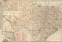
Viewing Options
Viewing Options
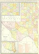
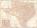
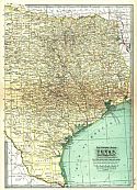
Main Author:
Rand McNally & Company
Publication Info:
Chicago: Rand McNally & Co., 1911; from Rand McNally's Indexed Atlas
Viewing Options
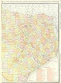
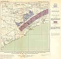
Main Author:
U.S. Geological Survey
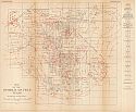
Title/Description:
Economic and Geologic Map of Llano Quadrangle, Texas
Publication Info:
Washington: Department of the Interior, U.S. Geological Survey, 1911; Bulletin 450 Plate III
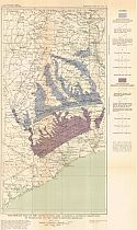
Viewing Options
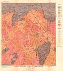
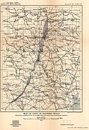
Main Author:
U.S. Geological Survey
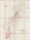
Title/Description:
Geologic Map of Northeast Texas
Publication Info:
Washington: Department of the Interior, U.S. Geological Survey, 1911; Water Supply Paper No. 276 Plate 1
Viewing Options
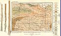
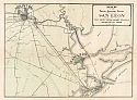
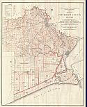
Main Author:
The Western Land Corporation
Title/Description:
Map of the Houston-Galveston District Showing the Location of San Leon and San Leon Farm Home Tracts, Galveston Co., Texas
Publication Info:
Houston: The Western Land Corporation, 1911
Viewing Options
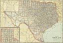
Main Author:
Cram, George F.
Publication Info:
Chicago: George F. Cram, 1911; from Cram's Unrivaled Atlas of the World
Viewing Options
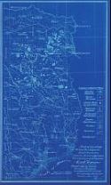
Main Author:
University of Texas, Bureau of Economic Geology and Technology
Title/Description:
Map of Locaton of Iron Ore Deposits, Blast Furnaces, Lignite Mines in Operation and Producing Oil Fields in East Texas
Publication Info:
blue print copy of original dated 1912, University of Texas Bureau of Economic Geology and Technology
Viewing Options
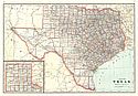
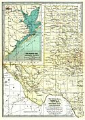
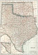
Main Author:
Rand McNally & Co.
Title/Description:
New Commercial Atlas Map of Texas
Publication Info:
Chicago: Rand McNally & Co., c.1912
Viewing Options
Main Author:
Rand McNally and Company
Publication Info:
Chicago: Rand McNally and Company, 1912; from The Rand McNally Imperial Atlas of the World
Viewing Options
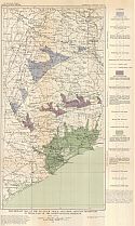
Main Author:
U.S. Geological Survey
Title/Description:
Map of Part of Eastern Texas Showing Distribution of Limestone Suitable for Portland Cement
Publication Info:
Washington: Department of the Interior, U.S. Geological Survey, 1912; Bulletin 522 Plate XVIII
Viewing Options
Main Author:
U.S. Geoligcal Survey
Title/Description:
Map of Oklahoma and Texas Showing Location of Limekilns and Quarries of Limestone, Sandstone, Marble and Granite
Publication Info:
Washington: Department of the Interior, U.S. Geological Survey, 1912; from Mineral Resources of the United States, 1912 Part II Plate V
Viewing Options
Viewing Options
Main Author:
The Century Company
Publication Info:
New York: The Century Company, 1913; from The Century Atlas of the World
Viewing Options
Main Author:
Cram, George F.
Publication Info:
Chicago: George F. Cram, 1913; from Cram's Unrivaled Atlas of the World
Viewing Options
Main Author:
Reynolds, Francis J.
Publication Info:
New York: P.F. Collier and Son, 1914; from The New Encyclopedic Atlas and Gazatteer of the World
Viewing Options
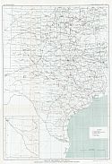
Main Author:
U.S. Geological Survey
Title/Description:
Geologic Map and Sections of Texas East of the Ninety-Seventh Meridian Showing Approximately the Areal Distribution of the Rock Groups and Formations
Publication Info:
Washington: Department of the Interior, U.S. Geological Survey, 1914; Water Supply Paper No. 335 Plate 1
Viewing Options
Main Author:
U.S. Geological Survey
Title/Description:
Preliminary Map of the Dewitt and Marine Miocene Artesian Reservoirs in Texas, East of the Ninety-Seventh Meridian
Publication Info:
Washington: Department of the Interior, U.S. Geological Survey, 1914; Water Supply Paper No. 335 Plate 9
Viewing Options
Main Author:
U.S. Geological Survey
Title/Description:
Preliminary Map of the Lower Eocene and Catahoula Artesian Reservoirs in Texas, East of the Ninety-Seventh Meridian
Publication Info:
Washington: Department of the Interior, U.S. Geological Survey, 1914; Water Supply Paper No. 335 Plate 8
Viewing Options
Main Author:
U.S. Geological Survey
Title/Description:
Prelimiary Map of the Nacatoch, Yegua and Lissie Artesian Reservoirs in Texas, East of the Ninety-seventh Meridian
Publication Info:
Washington: Department of the Interior, U.S. Geological Survey, 1914; Water Supply Paper No. 335 Plate 7
Viewing Options
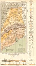
Main Author:
U.S. Department of Agriculture
Title/Description:
Map of Jefferson County Texas Showing Topography and Proposed Division of the County Into Drainage Districts
Publication Info:
Washington: U.S. Department of Agriculture, Bulletin No. 193, 1915

Viewing Options
Main Author:
Baker, Charles Laurence
Title/Description:
Map of the Shallow Water Area of Hale and Floyd Counties
Publication Info:
University of Texas Bureau of Economic Geology, 1915; Map 1 Bulletin No. 57
Viewing Options
Main Author:
U.S. Geological Survey
Title/Description:
Map of the Petrolia Gas Field, Texas
Publication Info:
Washington: Department of the Interior, U.S. Geological Survey, 1915 Bulletin 629 Plate I
Viewing Options
Main Author:
U.S. Geological Survey
Title/Description:
Map of the Mexia-Groesbeck Gas Field in Limestone County, Texas
Publication Info:
Washington: Department of the Interior, U.S. Geological Survey, 1915; Bulletin 629 Plate VI
Viewing Options
Main Author:
U.S. Geological Survey
Title/Description:
Map Showing Structures of Parts of the Area Between Wichita Valley Railway and Wichita River, in Clay County, Texas
Publication Info:
Washington: Department of the Interior, U.S. Geological Survey, 1915; Bulletin 629 Plate IV

Viewing Options
Main Author:
Rand McNally and Company
Publication Info:
Chicago: Rand McNally and Company, 1915; from The Ideal Atlas of the World