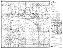
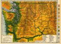
Viewing Options
Main Author:
Washington Geological Survey
Title/Description:
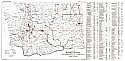
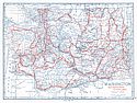
Map of Washington Showing locations of Mines, Quarries, Lime Kilns, Clay and Cement Plants and Other Mineral Industries
Publication Info:
Olympia: Washington Geological Survey, 1921; Plate I, Bulletin 21
Viewing Options
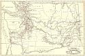
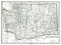
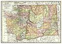
Main Author:
Rand McNally and Company
Title/Description:
Washington- Black and White Mileage Map
Publication Info:
Chicago: Rand McNally and Company, 1921; from The Commercial Atlas of America
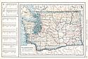
Viewing Options
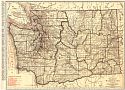
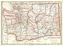
Main Author:
Rand McNally and Company
Title/Description:
Washington
Publication Info:
Chicago: Rand McNally and Company, 1921; from The Commercial Atlas of America
Viewing Options
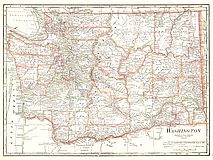
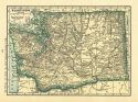
Main Author:
Cram, George F.
Title/Description:
Washington
Publication Info:
Chicago: George F. Cram Company, 1921; from Cram's Unrivaled Atlas of the World
Viewing Options
Main Author:
National Map Company
Title/Description:
Washington
Publication Info:
Indianapolis: National Map Company, 1921; from Auto Trails and Commercial Survey of the United States
Viewing Options
Main Author:
National Map Company
Title/Description:
Washington
Publication Info:
Indianapolis: National Map Company, 1921; from Auto Trails and Commercial Survey of the United States
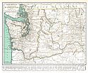
Viewing Options
Main Author:
Jenkins, Olaf P.
Title/Description:
Map of Washington Showing Locations of Iron Ore, Coal and Limestone Deposits
Publication Info:
Olympia: Washington Geological Survey, 1922; Plate I, Bulletin 27
Viewing Options
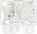
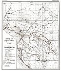
Main Author:
Jenkins, Olaf P.
Title/Description:
Map of White Bluff Hanford District Showing Features Relating to Underground Water Supply
Publication Info:
Olympia: Washington Geological Survey, 1922; Plate I, Bulletin 26
Viewing Options
Main Author:
The Geographical Publishing Co.
Title/Description:
Washington
Publication Info:
Chicago: The Geographical Publishing Co., 1922; from The New International Atlas of the World

Viewing Options
Main Author:
C.S. Hammond
Title/Description:
Washington
Publication Info:
New York: C.S. Hammond and Company, 1922; from The New World Looseleaf Atlas
Viewing Options
Main Author:
Jenkins, Olaf P.
Title/Description:
Geologic Map of the Coal Measures of Western Whatcom County
Publication Info:
Olympia: Washington Geological Survey, 1923; Plate I, Bulletin 28

Viewing Options
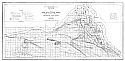
Main Author:
U.S. Geological Survey
Title/Description:
Map of The State Of Washington Showing Location Of Gaging Stations
Publication Info:
Washington: Department of the Interior, U.S. Geological Survey, 1923; Water Supply Paper No. 492 Plate 9
Viewing Options
Main Author:
Cram, George F.
Title/Description:
Washington
Publication Info:
Chicago: George F. Cram Company, 1923; from Cram's Unrivaled Atlas of the World
Viewing Options
Main Author:
Funk and Wagnalls Company
Title/Description:
Washington
Publication Info:
New York: Funk and Wagnalls Company, 1923; from Atlas of the World and Gazetteer
Viewing Options
Main Author:
Jenkins, Olaf P.
Title/Description:
Map of the Coal Measures of Skagit County
Publication Info:
Olympia: Washington Geological Survey, 1924; Plate I, Bulletin 29
Viewing Options
Main Author:
Reynolds, Francis J.
Title/Description:
Washington
Publication Info:
New York: P.F. Collier and Son Company, 1924; from The New World Atlas and Gazetteer
Viewing Options
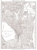
Main Author:
Reynolds, Francis J.
Title/Description:
Seattle
Publication Info:
New York: P.F. Collier and Son Company, 1924; from The New World Atlas and Gazetteer
Viewing Options
Main Author:
Rand McNally and Company
Title/Description:
Washington
Publication Info:
Chicago: Rand McNally and Company, 1925; from Premier Atlas of the World
Viewing Options
Main Author:
Clason Map Company
Title/Description:
Best Roads of Washington
Publication Info:
Chicago: Clason Map Company, c. 1927; from Clason's Touring Atlas
Viewing Options
Main Author:
National Map Company
Title/Description:
Washington
Publication Info:
Indianapolis: National Map Company, 1930; from Official Paved Road and Commercial Survey of the United States
Viewing Options
Main Author:
Clason Map Company
Title/Description:
Clason's Road Map of Washington
Publication Info:
Denver: The Clason Map Company, 1930; from Clason's Touring Atlas of the United States and Canada
Viewing Options
Main Author:
C.S. Hammond and Company
Title/Description:
Washington
Publication Info:
New York: C.S. Hammond and Company, c. 1930; from The New World Loose Leaf Atlas, Sixth Edition
Viewing Options
Main Author:
C.S. Hammond and Company
Title/Description:
Washington
Publication Info:
New York: C.S. Hammond and Company, c. 1930; from The New World Loose Leaf Atlas, Sixth Edition

