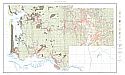
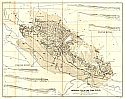
Viewing Options
Main Author:
U.S. Department of Agriculture
Title/Description:
Land Classification Map Reconnaissance Survey of Southwest Washington, Washington Chehalis Sheet
Publication Info:
Washington: U.S. Department of Agriculture, Bureau of Soils, 1911
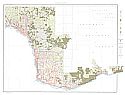
Viewing Options
Main Author:
U.S. Department of Agriculture
Title/Description:
Land Classification Map Reconnaissance Survey of Southwest Washington Washington, Vancouver Sheet
Publication Info:
Washington: U.S. Department of Agriculture, Bureau of Soils, 1911
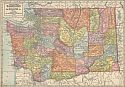
Viewing Options
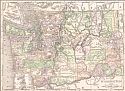
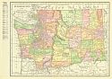
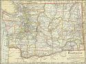
Main Author:
Geographical Publishing Company
Title/Description:
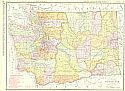
Washington
Publication Info:
Chicago: The Geographical Publishing Company, 1911
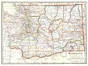
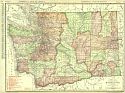
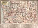
Viewing Options
Main Author:
Cram, George F.
Title/Description:
Washington
Publication Info:
Chicago: George F. Cram, 1911; from Cram's Unrivaled Atlas of the World
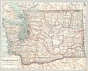
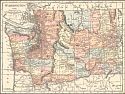
Viewing Options
Main Author:
Rand McNally & Company
Title/Description:
The Rand McNally New Commercial Atlas Map of Washington
Publication Info:
Chicago: Rand McNally & Co., 1912; from Rand McNally & Co.'s Library Atlas of the World
Viewing Options
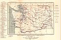
Main Author:
Washington Geological Survey
Title/Description:
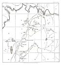
The Quincy Valley Irrigation Project - A Map Showing the Position of the Lands To Be Irrigated
Publication Info:
Olympia: Washington Geological Survey, 1912; Plate I, Bulletin 14
Viewing Options
Main Author:
Washington Geological Survey
Title/Description:
Map of the Coal Fields South of Green River, In The Vicinity of Bayne and Cumberland
Publication Info:
Olympia: Washington Geological Survey, 1912; Plate 23; Bulletin 3
Viewing Options
Main Author:
Washington Geological Survey
Title/Description:
Geological and Classification Map of the Coal Areas of King County, Washington
Publication Info:
Olympia: Washington Geological Survey, 1912; Plate I, Bulletin 3
Viewing Options
Main Author:
Rand McNally and Company
Title/Description:
Washington
Publication Info:
Chicago: Rand McNally and Company, 1912; from The Rand McNally Imperial Atlas of the World
Viewing Options
Main Author:
U.S. Geological Survey
Title/Description:
Map of Washington, Showing Location of Mining Districts
Publication Info:
Washington: Department of the Interior, U.S. Geological Survey, 1912; Bulletin 507 Plate XV
Viewing Options
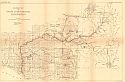
Main Author:
U.S. Geological Survey
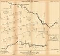
Title/Description:
Drainage Map of Cowlitz River, Washington
Publication Info:
Washington: Department of the Interior, U.S. Geological Survey, 1912; Water Supply Paper No. 313 Plate 1

Viewing Options
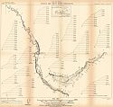
Main Author:
U.S. Geological Survey
Title/Description:
Map of Nisqually and Puyallup River Drainage Basins, Washington
Publication Info:
Washington: Department of the Interior, U.S. Geological Survey, 1912; Water Supply Paper No. 313 Plate 4
Viewing Options
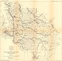
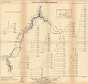
Main Author:
U.S. Geological Survey
Title/Description:
Map of White, Green, and Cedar River Drainage Basins, Washington
Publication Info:
Washington: Department of the Interior, U.S. Geological Survey, 1912; Water Supply Paper No. 313 Plate 11
Sheet 1
Sheet 2
Sheet 3
Sheet 4
Sheet 5
Sheet 6
Sheet 7
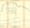
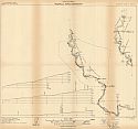
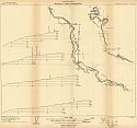
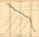
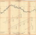
Main Author:
U.S. Geological Survey
Title/Description:
Plan and Profile, Cowlitz and Cispus Rivers, Washington
Publication Info:
Washington: Department of the Interior, U.S. Geological Survey, 1912; from Water Supply Paper No. 313 Plate VIII a-g
Sheet 1
Sheet 2
Sheet 3
Sheet 4
Sheet 5
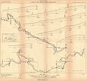
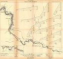
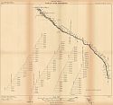
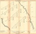
Main Author:
U.S. Geological Survey
Title/Description:
Plan and Profile, Nisqually River, Washington
Publication Info:
Washington: Department of the Interior, U.S. Geological Survey, 1912; from Water Supply Paper No. 313 Plate IX a-e

Sheet 1
Sheet 2
Sheet 3
Sheet 4
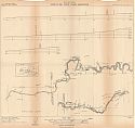
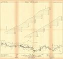
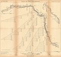
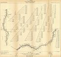
Main Author:
U.S. Geological Survey
Title/Description:
Plan and Profile, Puyallup River, Washington
Publication Info:
Washington: Department of the Interior, U.S. Geological Survey, 1912; from Water Supply Paper No. 313 Plate X a-d
Sheet 1
Sheet 2
Sheet 3
Sheet 4
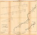
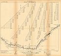
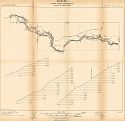
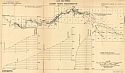
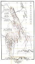
Main Author:
U.S. Geological Survey
Title/Description:
Plan and Profile, White River, Washington - Buckley to Mount Ranier
Publication Info:
Washington: Department of the Interior, U.S. Geological Survey, 1912; from Water Supply Paper No. 313 Plate XIV a-d
Viewing Options
Main Author:
U.S. Geological Survey
Title/Description:
Plan and Profile, Cedar River, Washington
Publication Info:
Washington: Department of the Interior, U.S. Geological Survey, 1912; Water Supply Paper No. 313 Plate 16
Viewing Options
Main Author:
Rand McNally & Company
Title/Description:
Washington
Publication Info:
Chicago: Rand McNally & Co., 1913
Viewing Options
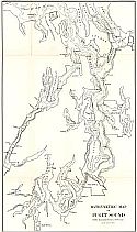
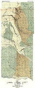
Main Author:
Washington Geological Survey
Title/Description:
Bathymetric Map of Puget Sound
Publication Info:
Olympia: Washington Geological Survey, 1913; Plate 24, Bulletin 8
Viewing Options
Main Author:
Washington Geological Survey
Title/Description:
Moraine and Outwash South of Puget Sound
Publication Info:
Olympia: Washington Geological Survey, 1913; Plate 23, Bulletin 8

Viewing Options
Main Author:
Washington Geological Survey
Title/Description:
Pleistocene Surface Deposits of Puget Sound Basin
Publication Info:
Olympia: Washington Geological Survey, 1913; Plate 22, Bulletin 8
Viewing Options
Main Author:
The Century Company
Title/Description:
Washington
Publication Info:
New York: The Century Company, 1913; from The Century Atlas of the World
Viewing Options
Main Author:
Cram, George F.
Title/Description:
Washington
Publication Info:
Chicago: George F. Cram, 1913; from Cram's Unrivaled Atlas of the World
Viewing Options
Main Author:
Washington Geological Survey
Title/Description:
Mine Workings and Structure Map, Wilkeson-Carbonado District, Pierce County Coal Field
Publication Info:
Olympia: Washington Geological Survey, 1914; Plate II, Bulletin 10
Viewing Options
Main Author:
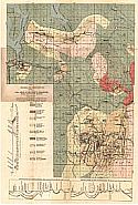
Washington Geological Survey
Title/Description:
Geological Map of Pierce County Coal Field
Publication Info:
Olympia: Washington Geological Survey, 1914; Plate I, Bulletin 10
Viewing Options
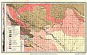
Main Author:
Washington Geological Survey
Title/Description:
Geological Map of the Coal Areas of Kittitas County
Publication Info:
Olympia: Washington Geological Survey, 1914; Plate I, Bulletin 9
Viewing Options
Main Author:
Washington Geological Survey
Title/Description:
Roslyn-Clealum Coal Field
Publication Info:
Olympia: Washington Geological Survey, 1914; Plate 2, Bulletin 9
Viewing Options
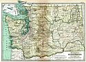
Main Author:
Rand McNally and Company
Title/Description:
Washington
Publication Info:
Chicago: Rand McNally and Co., 1914; from The Commercial Atlas of America
Viewing Options
Main Author:
Reynolds, Francis J.
Title/Description:
Washington
Publication Info:
New York: P.F. Collier and Son, 1914; from The New Encyclopedic Atlas and Gazatteer of the World
Viewing Options
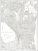
Main Author:
Reynolds, Francis J.
Title/Description:
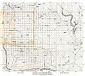
Map of the City of Seattle, Washington
Publication Info:
New York: P.F. Collier and Son, 1914; from The New Encyclopedic Atlas and Gazatteer of the World
Viewing Options
Main Author:
Scarborough Company
Title/Description:
New Commercial an Census Map of Washington
Publication Info:
Indianapolis: The National Map Company, 1915; from Scarborough's State Maps
Viewing Options
Main Author:
Rand McNally and Company
Title/Description:
Washington
Publication Info:
Chicago: Rand McNally and Company, 1915; from The Ideal Atlas of the World

