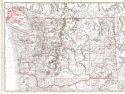
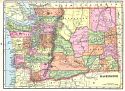
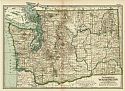
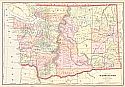
Viewing Options
Main Author:
Rand McNally and Company
Title/Description:
Washington
Publication Info:
Chicago: Rand McNally and Company, 1896; from Enlarged Business Atlas
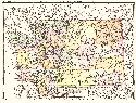
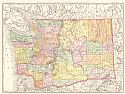
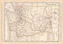
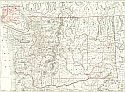
Viewing Options
Main Author:
Rand McNally and Company
Title/Description:
Washington
Publication Info:
Chicago: Rand McNally and Company,1896; from Indexed Atlas of the World
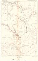
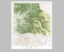
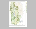
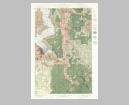
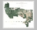
Viewing Options
Main Author:
U.S. Geological Survey
Title/Description:
Topographic Map, Wilkeson Coal Field, Pierce Co., Washington
Publication Info:
Washington: Department of the Interior, U.S. Geological Survey, 1897; 18th Annual Report, Part 3, Plate 59

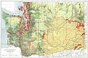
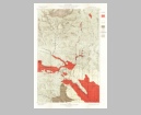
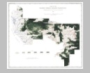
Viewing Options
Main Author:
U.S. Geological Survey
Title/Description:
Structure map of the Wilkeson Carbonado District
Publication Info:
Washington: Department of the Interior, U.S. Geological Survey, 1897; 18th Annual Report, Part 3, Plate 60
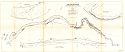
Viewing Options
Main Author:
US Army Corps of Engineers
Title/Description:
Lewis River, Washington from Columbia to La Center
Publication Info:
Washinton: US House of Representatives, 1897; House Document 64, 50th Congress, 1st Session
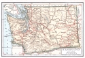
Viewing Options
Main Author:
Cram, George F.
Title/Description:
Washington
Publication Info:
Chicago: George F. Cram, 1898; from Cram's Universal Atlas, Geographical, Astronomical and Historical
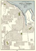
Viewing Options
Main Author:
Cram, George F.
Title/Description:
City of Tacoma, Washington
Publication Info:
Chicago: George F. Cram, 1898; from Cram's Universal Atlas, Geographical, Astronomical and Historical
Viewing Options
Main Author:
Rand McNally and Company
Title/Description:
Washington
Publication Info:
Chicago: Rand McNally & Co., 1898; from Rand McNally's Indexed Atlas of the World
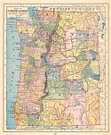
Viewing Options
Main Author:
Mast, Crowell and Kirkpatrick
Title/Description:
Map of Washington and Oregon
Publication Info:
Springfield, O.H.: Mast, Crowell and Kirkpatrick, 1898; from The Peerless Atlas of the World
Viewing Options
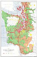
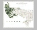
Main Author:
Rankine, John W. and Geo. H. Plummer
Title/Description:
Map of Western Washington Showing Classification of Lands
Publication Info:
Washington: Department of the Interior, U.S. Geological Survey, 1898; from the Nineteenth Annual Report, Part V PL. III
Viewing Options
Main Author:
U.S. Department of the Interior, U.S. Geological Survey
Title/Description:
Map of Western Washington Showing Density of Merchantable Timber
Publication Info:
Washington: Department of the Interior, U.S. Geological Survey, 1898; 19th Annual Report, Part V, PL. IV
Viewing Options
Main Author:
Plummer, G.H., Plummer, F.G., Raakine, J.H.
Title/Description:
Map of Washington Showing Classification of Lands
Publication Info:
Washington: Department of the Interior, U.S. Geological Survey, 1898
Viewing Options
Main Author:
U.S. Geological Survey
Title/Description:
Map of Washington Forest Reserve, Showing Distribution of Timber Species
Publication Info:
Washington: Department of the Interior, U.S. Geological Survey, 1898; from the Nineteenth Annual Report
Original Source:
Geological Survey of Alabama

Viewing Options
Main Author:
U.S. Geological Survey
Title/Description:
Map of Washington Forest Reserve, Showing Wooded, Burned, and Restocked Areas and the Density of Merchantable Timber, in Feet B.M.
Publication Info:
Washington: Department of the Interior, U.S. Geological Survey, 1898; from the Nineteeth Annaul Report
Original Source:
Geological Survey of Alabama
Viewing Options
Main Author:
U.S. Geological Survey
Title/Description:
Map of Priest River Forest Reserve Showing the Distribution of the Principal Timber Species
Publication Info:
Washington: Department of the Interior, U.S. Geological Survey, 1898; from the Nineteeth Annaul Report
Original Source:
Geological Survey of Alabama
Viewing Options
Main Author:
Smith, Benjamin E.
Title/Description:
Washington
Publication Info:
New York: The Century Company, 1899; from The Century Atlas of the World
Viewing Options
Main Author:
Cram, George F.
Title/Description:
Washington
Publication Info:
Chicago: George F. Cram, 1899; from The Standard American Railway System Atlas
Viewing Options
Main Author:
The Bradstreet Company
Title/Description:
Washington
Publication Info:
New York: The Bradstreet Company, 1899; from Bradstreet's Pocket Atlas of the United States
Viewing Options
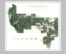
Main Author:
U.S. Geological Survey
Title/Description:
Mount Stuart Quadrangle, Land Classification and Density of Standing Timber
Publication Info:
Washington D.C.: U.S. Geological Survey, 1899
Viewing Options
Main Author:
U.S. Geological Survey
Title/Description:
Tacoma Quadrangle, Land Classification and Density of Standing Timber
Publication Info:
Washington D.C.: U.S. Geological Survey, 1899
Viewing Options
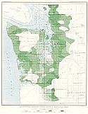
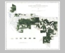
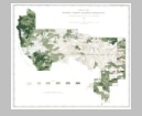
Main Author:
U.S. Geological Survey
Title/Description:
Part of the Olympic Forest Reserve, Washington, Showing the Proportion Which Silver Fir Bears to the Total Forest
Publication Info:
Washington D.C.: U.S. Geological Survey, 1899
Viewing Options
Main Author:
U.S. Geological Survey
Title/Description:
Part of the Olympic Forest Reserve, Washington, Showing the Proportion Which Spruce Bears to the Total Forest
Publication Info:
Washington D.C.: U.S. Geological Survey, 1899
Viewing Options
Main Author:
U.S. Geological Survey
Title/Description:
Part of the Olympic Forest Reserve, Washington, Showing the Proportion Which Cedar Bears to the Total Forest
Publication Info:
Washington D.C.: U.S. Geological Survey, 1899
Viewing Options
Main Author:
U.S. Geological Survey
Title/Description:
Part of the Olympic Forest Reserve, Washington, Showing the Proportion Which Hemlock Bears to the Total Forest
Publication Info:
Washington D.C.: U.S. Geological Survey, 1899
Viewing Options
Main Author:
U.S. Geological Survey
Title/Description:
Part of the Olympic Forest Reserve, Washington, Showing the Proportion Which Red Fir Bears to the Total Forest
Publication Info:
Washington D.C.: U.S. Geological Survey, 1899
Viewing Options
Main Author:
U.S. Geological Survey
Title/Description:
Part of the Olympic Forest Reserve, Washington, Showing Classification of Lands
Publication Info:
Washington D.C.: U.S. Geological Survey, 1899
Viewing Options
Main Author:
Cram, George F.
Title/Description:
Map of Washington
Publication Info:
Chicago: George F. Cram, c.1900
Viewing Options
Main Author:
Rand McNally and Company
Title/Description:
Washington Railroads
Publication Info:
Chicago: Rand McNally & Company, 1900

