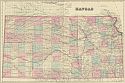
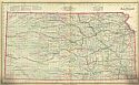
Viewing Options
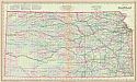
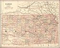
Main Author:
Gray, Ormando W.
Title/Description:
Kansas
Publication Info:
Philadelphia: O.W. Gray and Son, 1876; from Gray's National Atlas with Descriptions
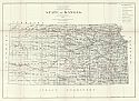
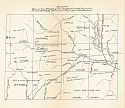
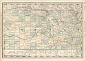
Viewing Options
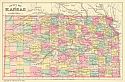
Title/Description:
State of Kansas
Publication Info:
Washington: Department of the Interior, General Land Office, 1876
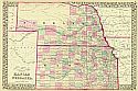
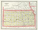
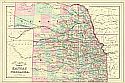
Viewing Options
Main Author:
Mitchell, Samuel Augustus
Title/Description:
County & Township Map of the States of Kansas and Nebraska
Publication Info:
Chicago: S.A. Mitchell, Jr., 1877
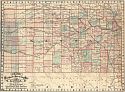
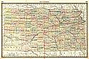
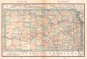
Viewing Options
Main Author:
Cram, George F.
Title/Description:
Cram's Railroad & Township Map of Kansas
Publication Info:
Chicago: George F. Cram, 1879
Viewing Options
Main Author:
Gray, Frank A.
Title/Description:
Gray's New Map of Kansas
Publication Info:
Philadelphia: O.W. Gray & Son, 1881
Viewing Options
Main Author:
Bradley, William M.
Title/Description:
County Map of Kansas
Publication Info:
Philadelphia: William M. Bradley, 1881
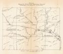
Viewing Options
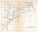
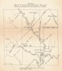
Title/Description:
Map of the Track of the "Irving Tornado" Embracing portions of Riley, Marshall, Nemaha Counties, Kansas. and Pawnee and Richardson Co's, Nebraska
Publication Info:
Washington: Government Printing Office, 1881; from Annual Report of the Chief Signal Officer to the Secretary of War
Viewing Options
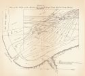
Title/Description:
Map of the Tracks of the Tornado's Nos. I and II through Irving, Marshall County, Kansas
Publication Info:
Washington: Government Printing Office, 1881; from Annual Report of the Chief Signal Officer to the Secretary of War
Viewing Options
Title/Description:
Map of the Track of the "Stockdale Tornado," Portions of Riley and Pottawattamie Counties, Kansas
Publication Info:
Washington: Government Printing Office, 1881; from Annual Report of the Chief Signal Officer to the Secretary of War
Viewing Options
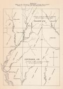
Title/Description:
Map of the Track of the "Pipe Creek Tornado," Ottawa and Cloud Counties, Kansas
Publication Info:
Washington: Government Printing Office, 1881; from Annual Report to the Chief Signal Officer to the Secretary of War
Viewing Options
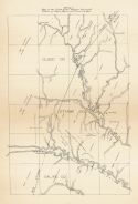
Title/Description:
Map of the Track of the "Delphos Tornado," Portions of Saline, Ottawa and Cloud Counties Kansas
Publication Info:
Washington: Government Printing Office, 1881; from Annual Report of the Chief Signal Officer to the Secretary of War
Viewing Options
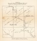
Title/Description:
Map of the Track of the "Wakefield Tornado," Portions of Clay and Riley Counties, Kansas
Publication Info:
Washington: Government Printing Office, 1881; from Annual Report of the Chief Signal Officer to the Secretary of War
Viewing Options
Title/Description:
Map of the Track of the "Waterville Tornado," Washington and Marshall Counties, Kansas
Publication Info:
Washington: Government Printing Office, 1881; from Annual Report of the Chief Signal Officer to the Secretary of War
Viewing Options
Title/Description:
Map of the Track of the "Buffalo Creek Tornado," Jewell, Mitchell, Cloud and Republic Counties. Kansas
Publication Info:
Washington: Government Printing Office, 1881; from Annual Report of the Chief Signal Officer to the Secretary of War

Viewing Options
Main Author:
Rand McNally and Company
Title/Description:
Kansas
Publication Info:
Chicago: Rand McNally and Company, 1881; from New Indexed Business Atlas and Shippers Guide
Viewing Options
Main Author:
Cram, George F.
Title/Description:
Kansas
Publication Info:
Chicago: George F. Cram, 1883

Viewing Options
Main Author:
Tunison, Henry C.
Title/Description:
Tunison's Kansas
Publication Info:
Jacksonville, IL: H.C. Tunison, 1883
Viewing Options
Main Author:
Hardesty, H.H.
Title/Description:
Map of Kansas
Publication Info:
New York: H.H. Hardesty & Co., 1883; from Hardesty's Historical and Geographical Encyclopedia
Viewing Options
Main Author:
O.W. Gray and Son
Title/Description:
Kansas
Publication Info:
Philadelphia: O.W. Gray and Son, 1883; from The National Atlas
Viewing Options
Main Author:
Watson, Gaylord
Title/Description:
Kansas
Publication Info:
Boston: Perry and Spaulding, 1883; from New Indexed Family Atlas of the United States with Maps of the World
Viewing Options
Main Author:
Mitchell, Samuel Augustus
Title/Description:
County & Township Map of the States of Kansas and Nebraska
Publication Info:
Philadelphia: S.A. Mitchell, Jr., 1884

Viewing Options
Main Author:
Cram, George F.
Title/Description:
Kansas
Publication Info:
Chicago: Henry S. Stebbins, 1884; from The Unrivaled Family Atlas of the World
Viewing Options
Main Author:
Rand McNally and Company
Title/Description:
Kansas
Publication Info:
Chicago: Rand McNally and Company, 1884; from The New Household Atlas of the World
Viewing Options
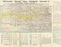
Main Author:
Ramsey, Millett & Hudson
Title/Description:
Where Does the Corn Grow? - Golden Belt Lands - Latest Township Map of Kansas, From Authentic Sources, Drawn and Engraved 1885, Expressly For the Land Department of the Kansas Division of the Union Pacific Railway
Publication Info:
Kansas City: Ramsey, Millett & Hudson, 1885; land promotion brochure issued by B. McAllaster, Land Commissioner, Kansas City, Missouri
Viewing Options
Main Author:
Rand McNally & Company
Title/Description:
Kansas
Publication Info:
Chicago: Rand McNally & Co., c. 1885; from the New Indexed Atlas of the World
Viewing Options
Main Author:
Tunison, Henry Cuthbert
Title/Description:
Kansas
Publication Info:
Jacksonville, IL: H.C. Tunison, 1885
Viewing Options
Main Author:
Rand McNally and Company
Title/Description:
Kansas
Publication Info:
Chicago: Rand McNally and Co., 1885; from the Standard Atlas of the World
Viewing Options
Main Author:
Cram, George F.
Title/Description:
Kansas
Publication Info:
Chicago: Henry S. Stebbing, 1885; from Cram's Unrivaled Family Atlas of the World

