
Viewing Options
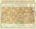
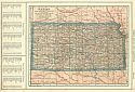
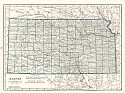
Title/Description:
Kansas
Publication Info:
Chicago: Geographical Publishing Co., 1916
Viewing Options
Main Author:
Rand McNally and Company
Title/Description:
Kansas
Publication Info:
Chicago: Rand McNally and Co., 1916; from the Ideal Atlas of the World
Viewing Options
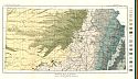
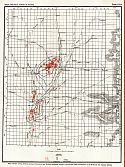
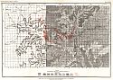
Main Author:
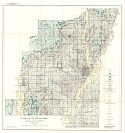
State Geological Survey of Kansas
Title/Description:
Geologic Map of Kansas
Publication Info:
Lawrence: State Geological Survey of Kansas, 1917; Bulletin 3
Viewing Options
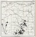
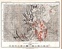
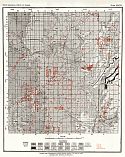
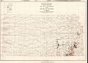
Main Author:
State Geological Survey of Kansas
Title/Description:
Map of Kansas oil and gas fields
Publication Info:
Lawrence: State Geological Survey of Kansas, 1917; Bulletin 3
Viewing Options
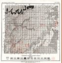
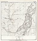
Main Author:
State Geological Survey of Kansas
Title/Description:
Geological map of Allen County showing location of oil and gas wells
Publication Info:
Lawrence: State Geological Survey of Kansas, 1917; Bulletin 3
Viewing Options
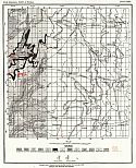
Main Author:
State Geological Survey of Kansas
Title/Description:
Map of Butler County, showing the Cottonwood and Wrenford Limestones, location of oil and gas wells and structure of the El Dorado and Augusta Districts
Publication Info:
Lawrence: State Geological Survey of Kansas, 1917; Bulletin 3
Viewing Options
Main Author:
State Geological Survey of Kansas
Title/Description:
Geologic Map of Chautauqua County, showing location of oil and gas wells
Publication Info:
Lawrence: State Geological Survey of Kansas, 1917; Bulletin 3
Viewing Options
Main Author:
State Geological Survey of Kansas
Title/Description:
Map of Cowley County, showing outcrop of Cottonwood and Wrenford Limestones and location of oil and gas wells
Publication Info:
Lawrence: State Geological Survey of Kansas, 1917; Bulletin 3
Viewing Options
Main Author:
State Geological Survey of Kansas
Title/Description:
Geologic Map of Labette County, showing location of oil and gas wells
Publication Info:
Lawrence: State Geological Survey of Kansas, 1917; Bulletin 3
Viewing Options
Main Author:
State Geological Survey of Kansas
Title/Description:
Geologic Map of Miami County and part of Franklin County, showing location of oil and gas wells
Publication Info:
Lawrence: State Geological Survey of Kansas, 1917; Bulletin 3
Viewing Options
Main Author:
State Geological Survey of Kansas
Title/Description:
Geologic Map of Montgomery County, showing location of oil and gas wells
Publication Info:
Lawrence: State Geological Survey of Kansas, 1917; Bulletin 3

Viewing Options
Main Author:
State Geological Survey of Kansas
Title/Description:
Geologic Map of Neosho County, showing location of oil and gas wells
Publication Info:
Lawrence: State Geological Survey of Kansas, 1917; Bulletin 3
Viewing Options
Main Author:
State Geological Survey of Kansas
Title/Description:
Geologic Map of Wilson County, showing location of oil and gas wells
Publication Info:
Lawrence: State Geological Survey of Kansas, 1917; Bulletin 3

Viewing Options
Main Author:
State Geological Survey of Kansas
Title/Description:
Geologic Map of Woodson County, showing location of oil and gas wells
Publication Info:
Lawrence: State Geological Survey of Kansas, 1917; Bulletin 3
Viewing Options
Main Author:
Reynolds, Francis J.
Title/Description:
Kansas
Publication Info:
New York: P.F. Collier and Son Company, 1920; from The New World Atlas and Gazetteer

Viewing Options
Main Author:
Cram, George F.
Title/Description:
Kansas
Publication Info:
Chicago: James R. Gray and Company, 1920; from Cram's Unrivaled Atlas of the World
Viewing Options
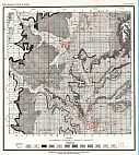
Main Author:
State Geological Survey of Kansas
Title/Description:
Map of the El Dorado Oil and Gas Field Showing Areal Geology and Structure of the Fort Riley Limestone
Publication Info:
Lawrence: State Geological Survey of Kansas, 1920; Bulletin 7
Viewing Options
Main Author:
U.S. Geological Survey
Title/Description:
Oil and Gas Fields of the State of Kansas
Publication Info:
Washington: Department of the Interior, U.S. Geological Survey, 1920
Viewing Options
Main Author:
C.S. Hammond and Company
Title/Description:
Kansas
Publication Info:
New York: C.S. Hammond and Company, 1920; from The New Reference Atlas of the World
Original Source:
Courtesy of Shawn Carter

