
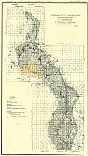
Viewing Options
Main Author:
Department of Geology and Natural Resources of Indiana
Title/Description:
The Distribution of Road Material in Warrick, Spencer and Perry Counties
Publication Info:
Indianapolis: Indiana Department of Geology and Natural Resources, 1906; from 30th Annual Report of 1905

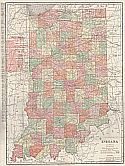
Viewing Options
Main Author:
Rand McNally and Company
Title/Description:
Indiana
Publication Info:
Chicago: Rand McNally and Company; 1906; from The Business Atlas and Shippers Guide

Viewing Options
Main Author:
Department of Geology and Natural Resources of Indiana
Title/Description:
Road Map of Monroe County, Indiana
Publication Info:
Indianapolis: Indiana Department of Geology and Natural Resources, 1906; from 30th Annual Report of 1905

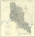
Viewing Options
Main Author:
Department of Geology and Natural Resources of Indiana
Title/Description:
Map Illustrating the Roads and distribution of Road Materials in Orange and Washington counties
Publication Info:
Indianapolis: Indiana Department of Geology and Natural Resources, 1906; from 30th Annual Report of 1905

Viewing Options
Main Author:
Department of Geology and Natural Resources of Indiana
Title/Description:
Map Illustrating the Roads and Distribution of Road Materials in Owen and Greene Counties
Publication Info:
Indianapolis: Indiana Department of Geology and Natural Resources, 1906; from 30th Annual Report of 1905

Viewing Options
Main Author:
Department of Geology and Natural Resources of Indiana
Title/Description:
Map Illustrating the Distribution of Road Material in Vigo County
Publication Info:
Indianapolis: Indiana Department of Geology and Natural Resources, 1906; from 30th Annual Report of 1905

Viewing Options
Main Author:
Department of Geology and Natural Resources of Indiana
Title/Description:
Map Illustrating the Distribution of Road Materials in Tippecanoe, Warren, Fountain, Montgomery and Parke Counties
Publication Info:
Indianapolis: Indiana Department of Geology and Natural Resources, 1906; from 30th Annual Report of 1905

Viewing Options
Main Author:
C.S. Hammond and Company
Title/Description:
Indiana
Publication Info:
New York: C.S. Hammond and Company; 1906; from The Pictorial Atlas of the World

Viewing Options
Main Author:
Department of Geology and Natural Resources of Indiana
Title/Description:
Map of the Princeton Oil Field
Publication Info:
Indianapolis: Department of Geology and Natural History, 1906; from the Department's 31st Annual Report

Viewing Options
Main Author:
Rand McNally and Company
Title/Description:
Indiana
Publication Info:
Chicago: Rand McNally and Company, 1906; from The World and its Peoples
Viewing Options
Main Author:
Siebenthal, C.E.
Title/Description:
Geologic Map of the Indiana Oolitic Limestone Region (Bloomington Sheet)
Publication Info:
Department of Geology and Natural Resources of Indiana, 1907; from the Departments' 32nd Annual Report, 1907
Viewing Options
Main Author:
Department of Geology and Natural Resources of Indiana
Title/Description:
Map of the Counties of Dearborn, Ohio, Switzerland, Jefferson and Ripley Showing the location of sections and collecting localities and the boundary between the Ordovician and Silurian Systems
Publication Info:
Department of Geology and Natural Resources of Indiana, 1907; from the Departments' 32nd Annual Report, 1907
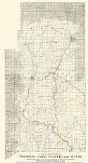
Viewing Options
Main Author:
Department of Geology and Natural Resources of Indiana
Title/Description:
Map of the Counties of Franklin, Union, Fayette and Wayne Showing the location of sections and collecting localities and the boundary between the Ordovician and Silurian Systems
Publication Info:
Department of Geology and Natural Resources of Indiana, 1907; from the Departments' 32nd Annual Report, 1907
Viewing Options
Main Author:
Siebenthal, C.E.
Title/Description:
Geologic Map of the Indiana Oolitic Limestone Region (Bedford Sheet)
Publication Info:
Department of Geology and Natural Resources of Indiana, 1907; from the Departments' 32nd Annual Report, 1907

Viewing Options
Main Author:
Cram, George F.
Title/Description:
Indiana
Publication Info:
Chicago: George F. Cram, 1907; from Cram's Standard American Atlas

Viewing Options
Main Author:
P.F. Collier and Son
Title/Description:
Indiana
Publication Info:
New York: P.F. Collier and Son, 1907; from The New Encyclopedic Atlas and Gazetteer of the World
Viewing Options
Main Author:
Rand McNally & Co.
Title/Description:
Indiana
Publication Info:
Chicago: Rand McNally & Co., 1908; with railroads marked in red

Viewing Options
Main Author:
Department of Geology and Natural Resources of Indiana
Title/Description:
Bedford and Vicinity
Publication Info:
Indianapolis: Indiana Department of Geology and Natural Resources, 1908; from the 32nd annual report of 1907

Viewing Options
Main Author:
Department of Geology and Natural Resources of Indiana
Title/Description:
Bloomington
Publication Info:
Indianapolis: Indiana Department of Geology and Natural Resources, 1908; from the 32nd annual report of 1907

Viewing Options
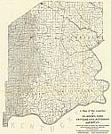
Main Author:
Department of Geology and Natural Resources of Indiana
Title/Description:
Martin County Soil Survey
Publication Info:
Indianapolis: Indiana Department of Geology and Natural Resources, 1908; from the 32nd annual report of 1907

Viewing Options
Main Author:
Department of Geology and Natural Resources of Indiana
Title/Description:
Orange County Soil map
Publication Info:
Indianapolis: Indiana Department of Geology and Natural Resources, 1908; from the 32nd Annual Report of 1907

Viewing Options
Main Author:
Crowell Publishing Company
Title/Description:
Indiana
Publication Info:
New York: The Crowell Publishing Co., 1908; from The Twentieth Century Peerless Atlas

Viewing Options
Main Author:
Department of Geology and Natural Resources of Indiana
Title/Description:
Dubois County Soil Map
Publication Info:
Indianapolis: Department of Geology and Natural History, 1908; from the Department's 33rd Annual Report

Viewing Options
Main Author:
Department of Geology and Natural Resources of Indiana
Title/Description:
Perry County Soil Map
Publication Info:
Indianapolis: Department of Geology and Natural History, 1908; from the Department's 33rd Annual Report

Viewing Options
Main Author:
Department of Geology and Natural Resources of Indiana
Title/Description:
Soil Map of Daviess County
Publication Info:
Indianapolis: Department of Geology and Natural History, 1908; from the Department's 33rd Annual Report

Viewing Options
Main Author:
Hammond, C.S.
Title/Description:
Indiana
Publication Info:
New York: C.S. Hammond & Co. 1908; from Hammond's Handy Atlas of the World

Viewing Options
Main Author:
Rand McNally and Company
Title/Description:
Indiana
Publication Info:
Chicago: Rand McNally and Company, 1908; from The New Ideal State and County Survey and Atlas

Viewing Options
Main Author:
Rand McNally and Company
Title/Description:
Indiana
Publication Info:
Chicago: Rand McNally and Company, 1908; from The New Ideal State and County Survey and Atlas

Viewing Options
Main Author:
Patten, William and J.E. Homas
Title/Description:
Indiana
Publication Info:
New York: P.F. Collier and Son, 1909; from The New Encyclopedic Atlas and Gazetteer of the World

Viewing Options
Main Author:
Cram, George F.
Title/Description:
Indiana
Publication Info:
Chicago: George F. Cram, c.1909; from the Heart of our Country

Viewing Options
Main Author:
Department of Geology and Natural Resources of Indiana
Title/Description:
Soil Map of Randalph County
Publication Info:
Indianapolis: Department of Geology and Natural History, 1909; from the Department's 34th Annual Report

Viewing Options
Main Author:
Department of Geology and Natural Resources of Indiana
Title/Description:
Soil Map of Henry County
Publication Info:
Indianapolis: Department of Geology and Natural History, 1909; from the Department's 34th Annual Report

Viewing Options
Main Author:
Department of Geology and Natural Resources of Indiana
Title/Description:
Rush County Soil Map
Publication Info:
Indianapolis: Department of Geology and Natural History, 1909; from the Department's 34th Annual Report

Viewing Options
Main Author:
Department of Geology and Natural Resources of Indiana
Title/Description:
Union County Soil Map
Publication Info:
Indianapolis: Department of Geology and Natural History, 1909; from the Department's 34th Annual Report

Viewing Options
Main Author:
Department of Geology and Natural Resources of Indiana
Title/Description:
Franklin County Soil Map
Publication Info:
Indianapolis: Department of Geology and Natural History, 1909; from the Department's 34th Annual Report

Viewing Options
Main Author:
Department of Geology and Natural Resources of Indiana
Title/Description:
Vangerburch County Soil Map
Publication Info:
Indianapolis: Department of Geology and Natural History, 1909; from the Department's 34th Annual Report

Viewing Options
Main Author:
Department of Geology and Natural Resources of Indiana
Title/Description:
Gibson County Soil Map
Publication Info:
Indianapolis: Department of Geology and Natural History, 1909; from the Department's 34th Annual Report

Viewing Options
Main Author:
Department of Geology and Natural Resources of Indiana
Title/Description:
Pike County Soil Map
Publication Info:
Indianapolis: Department of Geology and Natural History, 1909; from the Department's 34th Annual Report

Viewing Options
Main Author:
Department of Geology and Natural Resources of Indiana
Title/Description:
Warrick and Spencer Counties Soil Map
Publication Info:
Indianapolis: Department of Geology and Natural History, 1909; from the Department's 34th Annual Report

Viewing Options
Main Author:
Rand McNally and Company
Title/Description:
Indiana
Publication Info:
Chicago: Rand McNally and Company, 1910; from Enlarged Business Atlas and Shippers Guide

Viewing Options
Main Author:
Department of Geology and Natural Resources of Indiana
Title/Description:
Map of the Oakland City, Indiana Oil Field, December 1, 1910
Publication Info:
Indianapolis: Department of Geology and Natural History, 1910; from the Department's 35th Annual Report

Viewing Options
Main Author:
Rand McNally and Company
Title/Description:
Indiana
Publication Info:
Chicago: Rand McNally and Company 1910; from New Ideal State and County Survey

Viewing Options
Main Author:
C.S. Hammond and Company
Title/Description:
Indiana
Publication Info:
New York: C.S. Hammond and Company,1910; from The New Reference Atlas of the World

