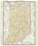
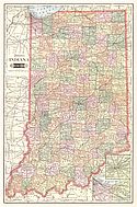
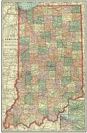
Viewing Options
Main Author:
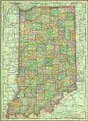
Rand McNally & Company
Title/Description:
New Map of Indiana
Publication Info:
Chicago: Rand McNally & Co., 1901; from Rand McNally and Co.'s Atlas of the World
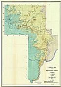
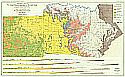
Viewing Options
Main Author:
Newsom, J.F.
Title/Description:
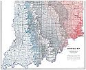
Geologic Map of the Knobstone Group, Indiana - New Albany Sheet (Plate III)
Publication Info:
Department of Geology and Natural Resources of Indiana, 1901; from the Departments' 26th Annual Report, 1901
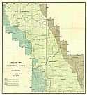
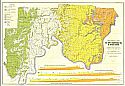
Viewing Options
Main Author:
Newsom, J.F.
Title/Description:
Geologic Map of the Knobstone Group, Indiana - Crawfordsville Sheet (Plate IV)
Publication Info:
Department of Geology and Natural Resources of Indiana, 1901; from the Departments' 26th Annual Report, 1901
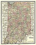
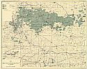
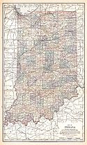
Viewing Options
Main Author:
Cram, George F.
Title/Description:
Indiana
Publication Info:
Chicago: The Fort Dearborn Publishing Co., 1901; from The National Standard Family and Business Atlas of the World
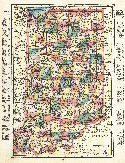
Viewing Options
Main Author:
Tunison, Henry Cuthbert
Title/Description:
Indiana
Publication Info:
New York: H.C. Tunison, 1901; from Tunison's Atlas, Encyclopædia, Gazetteer, and Portfolio of Our Universe, Globe, and Nation

Viewing Options
Main Author:
The Century Company
Title/Description:
Indiana
Publication Info:
Buffalo: The Matthews-Northrup Co., 1902; from the Century Atlas
Original Source:
From the personal collection of Dr. Robert Burckhalter, Santa Fe, NM
Viewing Options
Main Author:
Ashley, George H.
Title/Description:
Geologic Map of the Lower Carboniferous Area of Southern Indiana (Salem Sheet)
Publication Info:
Department of Geology and Natural Resources of Indiana, 1902; from the Departments' 27th Annual Report, 1902
Viewing Options
Main Author:
Ashley, George H.
Title/Description:
Geological Map - The Lower Carboniferous Area of Southern Indiana (Corydon Sheet)
Publication Info:
Department of Geology and Natural Resources of Indiana, 1902; from the Departments' 27th Annual Report, 1902
Viewing Options
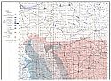
Main Author:
Blatchley, W.S.
Title/Description:
Map of the Main Trenton Rock Oil Field of Indiana
Publication Info:
Department of Geology and Natural Resources of Indiana, 1903; from the Departments' 28th Annual Report, 1903
Viewing Options
Main Author:
Cram, George F.
Title/Description:
Indiana
Publication Info:
Chicago: George F. Cram, 1903
Viewing Options
Main Author:
The Crowell Publishing Company
Title/Description:
Indiana
Publication Info:
Springfield, Ohio: The Crowell Publishing Company, 1903; from The Twentieth Century Peerless Atlas and Pictorial Gazetteer
Viewing Options
Main Author:
Cram, George F.
Title/Description:
Indiana
Publication Info:
Philadelphia: The Philadelphia Inquirer,1903; from Pictorial Atlas of the Greater United States and the World
Viewing Options
Viewing Options
Main Author:
Hopkins, T.C.
Title/Description:
Geological Map of Indiana
Publication Info:
Department of Geology and Natural Resources of Indiana, c.1904

Viewing Options
Main Author:
Miller, J. Martin
Title/Description:
Indiana
Publication Info:
Unknown, 1904; from the Twentieth Century Atlas and Illustrated World
Viewing Options
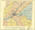
Title/Description:
Geologic Map of Allen County Showing Sand and Gravel Deposits
Publication Info:
Department of Geology and Natural Resources of Indiana, 1905; from the Departments' 30th Annual Report, 1905
Viewing Options
Main Author:
Rand McNally and Company
Title/Description:
Indiana
Publication Info:
Chicago: Rand McNally and Co., 1905; from Unrivaled Atlas of the World

