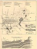
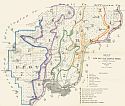
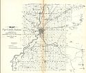
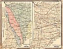
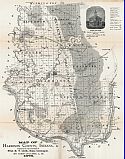
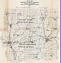
Viewing Options
Main Author:
Wright, S.D.
Title/Description:
Survey of Part of the Coal Fields, Daviess County, Indiana
Publication Info:
Indianapolis: Geological Survey of Indiana, 1871
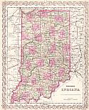
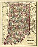
Viewing Options
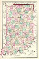
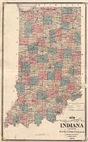
Main Author:
Colton, G.W. & C.B. Colton
Title/Description:
Colton's Indiana
Publication Info:
New York: G.W. & C.B. Colton, c1873
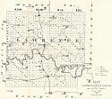
Viewing Options
Main Author:
Department of Geology and Natural History of Indiana
Title/Description:
Map of Lawrence County, Indiana
Publication Info:
Department of Geology and Natural History, 1873; report by E.T. Cox for the Department's 5th Annual Report
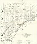
Viewing Options
Main Author:
Department of Geology and Natural History of Indiana
Title/Description:
Map of Warren County, IN
Publication Info:
Department of Geology and Natural History, 1873; report by E.T. Cox for the Department's 5th Annual Report
Viewing Options
Main Author:
Department of Geology and Natural History of Indiana
Title/Description:
Map of Clarke and Floyd Counties, Indiana
Publication Info:
Department of Geology and Natural History, 1873; report by E.T. Cox for the Department's 5th Annual Report
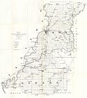
Viewing Options
Main Author:
Department of Geology and Natural History of Indiana
Title/Description:
Map of Knox and Gibson Counties
Publication Info:
Department of Geology and Natural History, 1873; report by John Collett for the Department's 5th Annual Report
Viewing Options
Main Author:
Gray, Ormando W.
Title/Description:
Indiana
Publication Info:
Philadelphia: Stedman, Brown and Lyon 1873; from Gray's Atlas of the United States with General Maps of the World
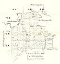
Viewing Options
Main Author:
Department of Geology and Natural History of Indiana
Title/Description:
Map of Scott County, Indiana
Publication Info:
Department of Geology and Natural History, 1874; report by W.W. Borden for the Department's 6th Annual Report
Viewing Options
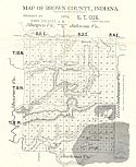
Main Author:
Department of Geology and Natural History of Indiana
Title/Description:
Map of Brown County, Indiana
Publication Info:
Department of Geology and Natural History, 1874; report by John Collett for the Department's 6th Annual Report
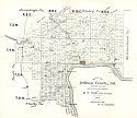
Viewing Options
Main Author:
Department of Geology and Natural History of Indiana
Title/Description:
Map of Jefferson County, Indiana
Publication Info:
Department of Geology and Natural History, 1874; report by W.W. Borden for the Department's 6th Annual Report
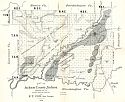
Viewing Options
Main Author:
Department of Geology and Natural History of Indiana
Title/Description:
Map of Jackson County, Indiana
Publication Info:
Department of Geology and Natural History, 1874; prepared for the Department's 6th Annual Report
Viewing Options
Main Author:
Department of Geology and Natural History of Indiana
Title/Description:
Map of Owen County, Indiana
Publication Info:
Department of Geology and Natural History, 1875; report by John Collett for the Department's 7th Annual Report
Viewing Options
Main Author:
Department of Geology and Natural History of Indiana
Title/Description:
Map of Vigo County, Indiana
Publication Info:
Department of Geology and Natural History of Indiana; report by E.T. Cox for the Department's 7th Annual Report
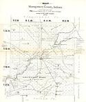
Viewing Options
Main Author:
Department of Geology and Natural History of Indiana
Title/Description:
Map of Montgomery County, Indiana
Publication Info:
Department of Geology and Natural History, 1875; report by John Collett for the Department's 7th Annual Report
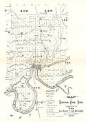
Viewing Options
Main Author:
Department of Geology and Natural History of Indiana
Title/Description:
Map of Vanderburgh County, Indiana
Publication Info:
Department of Geology and Natural History, 1875; report by John Collett for the Department's 7th Annual Report
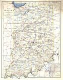
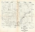
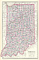
Viewing Options
Main Author:
A. von Steinwehr, A.M.
Title/Description:
Map of Indiana
Publication Info:
Buffalo: H. Chandler, (c1876)
Viewing Options
Main Author:
Gray, Frank A.
Title/Description:
Indiana
Publication Info:
Philadelphia: O.W. Gray & Son, c1876
Viewing Options
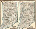
Main Author:
Baskin, Forester & Co.
Title/Description:
Geological Map of Indiana - Climatological Map of Indiana
Publication Info:
Chicago: Baskin, Forester & Co., 1876; from their Illustrated Atlas of the State of Indiana
Viewing Options
Main Author:
Baskin, Forester, & Co.
Title/Description:
Congressional Districts - Judicial Districts
Publication Info:
Chicago: Baskin, Forester & Co., 1876; from their Illustrated Atlas of the State of Indiana
Viewing Options
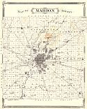
Main Author:
Durant, S.W.
Title/Description:
Map of Marion County
Publication Info:
Chicago: Baskin, Forester & Co., 1876; from the Illustrated Atlas of the State of Indiana
Viewing Options
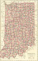
Main Author:
Baskin, Forester & Co.
Title/Description:
New Sectional and Township Map of Indiana
Publication Info:
Chicago: Baskin, Forester & Co., 1876; from the Illustrated Historical Atlas of the State of Indiana
Viewing Options
Main Author:
Gray, Ormando W.
Title/Description:
Indiana
Publication Info:
Philadelphia: O.W. Gray and Son, 1876; from Gray's National Atlas with Descriptions
Viewing Options
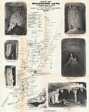
Main Author:
Department of Geology and Natural Resources
Title/Description:
Map of Wyandotte Cave in Crawford County, Indiana
Publication Info:
Indianapolis: Department of Geology and Natural History, 1878; from the Department's 10th Annual Report

Viewing Options
Main Author:
Department of Geology and Natural Resources
Title/Description:
Map of Crawford County, Indiana
Publication Info:
Indianapolis: Department of Geology and Natural History, 1878; from the Department's 10th Annual Report
Viewing Options
Main Author:
Department of Geology and Natural Resources
Title/Description:
Map of Harrison County, Indiana
Publication Info:
Indianapolis: Department of Geology and Natural History, 1878; from the Department's 10th Annual Report
Viewing Options
Main Author:
Department of Geology and Natural Resources
Title/Description:
Map of Wayne County, Indiana
Publication Info:
Indianapolis: Department of Geology and Natural History, 1878; from the Department's 10th Annual Report
Viewing Options
Main Author:
Gray, Frank A.
Title/Description:
Indiana
Publication Info:
Philadelphia: O.W. Gray & Son, 1880; from The National Altas
Viewing Options
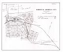
Main Author:
U.S. Army Corps of Engineers
Title/Description:
Harbor of Michigan City
Publication Info:
Washington: U.S. Army Corps of Engineers, c. 1880

