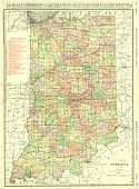
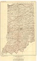
Viewing Options
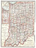
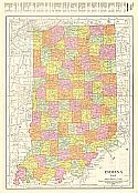
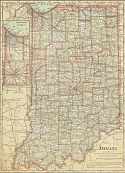
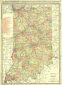
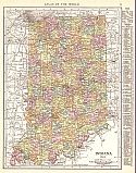
Main Author:
Rand McNally and Company
Title/Description:
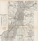
Indiana
Publication Info:
Chicago: Rand McNally and Co., 1911; from the Commercial Atlas of America
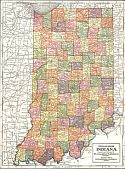
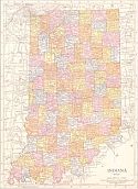
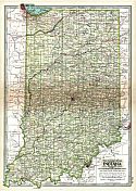
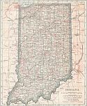
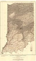
Viewing Options
Title/Description:
Indiana
Publication Info:
Chicago: Geographical Publishing Company, 1911
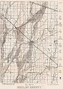
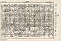
Viewing Options
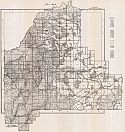
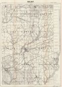
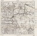
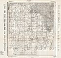
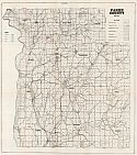
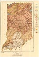
Main Author:
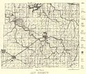
Department of Geology and Natural Resources
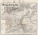
Title/Description:
Soil Map of Shelby County
Publication Info:
Indianapolis: Department of Geology and Natural History, 1911; from the Department's 36th Annual Report
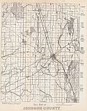
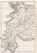
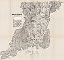
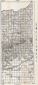
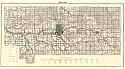
Viewing Options
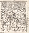
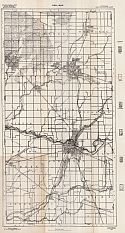
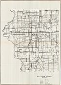
Main Author:
Department of Geology and Natural Resources
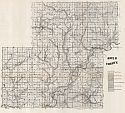
Title/Description:
Soil Map of Johnson County
Publication Info:
Indianapolis: Department of Geology and Natural History, 1911; from the Department's 36th Annual Report
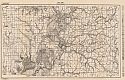
Viewing Options
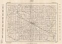
Main Author:
Department of Geology and Natural Resources
Title/Description:
Morgan County, Indiana
Publication Info:
Indianapolis: Department of Geology and Natural History, 1911; from the Department's 36th Annual Report
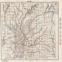
Viewing Options
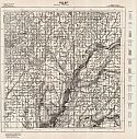
Main Author:
Department of Geology and Nautral Resources
Title/Description:
Owen County
Publication Info:
Indianapolis: Department of Geology and Natural History, 1911; from the Department's 36th Annual Report
Viewing Options
Main Author:
Department of Geology and Natural Resources
Title/Description:
Soil Map of Hancock County
Publication Info:
Indianapolis: Department of Geology and Natural History, 1911; from the Department's 36th Annual Report
Viewing Options
Main Author:
Department of Geology and Natural Resources
Title/Description:
Sullivan County
Publication Info:
Indianapolis: Department of Geology and Natural History, 1911; from the Department's 36th Annual Report
Viewing Options
Main Author:
Department of Geology and Natural Resources
Title/Description:
Vigo County
Publication Info:
Indianapolis: Department of Geology and Natural History, 1911; from the Department's 36th Annual Report
Viewing Options
Main Author:
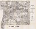
Department of Geology and Natural Resources
Title/Description:
St. Joseph County
Publication Info:
Indianapolis: Department of Geology and Natural History, 1911; from the Department's 36th Annual Report
Viewing Options
Main Author:
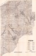
Department of Geology and Natural Resources
Title/Description:
LaPorte County
Publication Info:
Indianapolis: Department of Geology and Natural History, 1911; from the Department's 36th Annual Report
Viewing Options
Main Author:
Department of Geology and Natural Resources
Title/Description:
Bartholomew County
Publication Info:
Indianapolis: Department of Geology and Natural History, 1911; from the Department's 36th Annual Report
Viewing Options
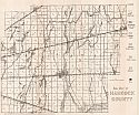
Main Author:
Department of Geology and Natural Resources
Title/Description:
Scott County Soil Map
Publication Info:
Indianapolis: Department of Geology and Natural History, 1911; from the Department's 36th Annual Report
Viewing Options
Main Author:
Department of Geology and Natural Resources
Title/Description:
Posey County Soil Map
Publication Info:
Indianapolis: Department of Geology and Natural History, 1911; from the Department's 36th Annual Report
Viewing Options
Main Author:
Department of Geology and Natural Resources
Title/Description:
Greene County Soil Map
Publication Info:
Indianapolis: Department of Geology and Natural History, 1911; from the Department's 36th Annual Report
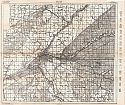
Viewing Options
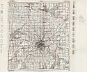
Main Author:
Department of Geology and Natural Resources
Title/Description:
Marion County Soil Map
Publication Info:
Indianapolis: Department of Geology and Natural History, 1911; from the Department's 36th Annual Report
Viewing Options
Main Author:
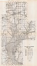
Department of Geology and Natural Resources
Title/Description:
Clay County Soil Map
Publication Info:
Indianapolis: Department of Geology and Natural History, 1912; from the Department's 36th Annual Report
Viewing Options
Main Author:
Cram, George F.
Title/Description:
Indiana
Publication Info:
Chicago: George F. Cram, 1911; from Cram's Unrivaled Atlas of the World
Viewing Options
Main Author:
Rand McNally and Company
Title/Description:
Indiana
Publication Info:
Chicago: Rand McNally and Company, 1912; from The Rand McNally Imperial Atlas of the World
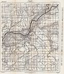
Viewing Options
Main Author:
Department of Geology and Natural Resources
Title/Description:
Knox County
Publication Info:
Indianapolis: Department of Geology and Natural History, 1912; from the Department's 36th Annual Report
Viewing Options
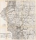
Main Author:
Department of Geology and Natural Resources
Title/Description:
Putnam County Soil Map
Publication Info:
Indianapolis: Department of Geology, 1912; from the Department's 37th Annual Report
Viewing Options
Main Author:
Department of Geology
Title/Description:
Montgomery County Soil Map
Publication Info:
Indianapolis: Department of Geology, 1912; from the Department's 37th Annual Report
Viewing Options
Main Author:
Department of Geology
Title/Description:
Boone County Soil Map
Publication Info:
Indianapolis: Department of Geology, 1912; from the Department's 37th Annual Report
Viewing Options
Main Author:
Department of Geology
Title/Description:
Hamilton County Soil Map
Publication Info:
Indianapolis: Department of Geology, 1912; from the Department's 37th Annual Report
Viewing Options
Main Author:
Department of Geology
Title/Description:
Tipton County Soil Survey
Publication Info:
Indianapolis: Department of Geology, 1912; from the Department's 37th Annual Report
Viewing Options
Main Author:
Department of Geology
Title/Description:
Newton County Soil Map
Publication Info:
Indianapolis: Department of Geology, 1912; from the Department's 37th Annual Report
Viewing Options
Main Author:
Department of Geology
Title/Description:
Allen County Soil Map
Publication Info:
Indianapolis: Department of Geology, 1912; from the Department's 37th Annual Report
Viewing Options
Main Author:
Department of Geology
Title/Description:
Tippecanoe County Soil Map
Publication Info:
Indianapolis: Department of Geology, 1912; from the Department's 37th Annual Report
Viewing Options
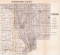
Main Author:
Department of Geology
Title/Description:
Marshall County Soil Survey Map
Publication Info:
Indianapolis: Department of Geology, 1912; from the Department's 37th Annual Report
Viewing Options
Main Author:
Department of Geology
Title/Description:
Madison County Soil Map
Publication Info:
Indianapolis: Department of Geology, 1912; from the Department's 37th Annual Report
Viewing Options
Main Author:
Rand McNally & Company
Title/Description:
Rand McNally and Co.'s New Map of Indiana
Publication Info:
Chicago: Rand McNally & Co., 1913; from The Rand McNally Banker's Directory and List of Attorneys, 76th Edition
Viewing Options
Main Author:
The Century Company
Title/Description:
Indiana
Publication Info:
New York: The Century Company, 1913; from The Century Atlas of the World
Viewing Options
Main Author:
Cram, George F.
Title/Description:
Indiana
Publication Info:
Chicago: George F. Cram, 1913; from Cram's Unrivaled Atlas of the World
Viewing Options
Main Author:
Department of Geology
Title/Description:
Hendricks County Soil Map
Publication Info:
Indianapolis: Department of Geology, 1913; from the Department's 38th Annual Report
Viewing Options
Main Author:
Department of Geology
Title/Description:
Sullivan County
Publication Info:
Indianapolis: Department of Geology, 1913; from the Department's 38th Annual Report
Viewing Options
Main Author:
Department of Geology
Title/Description:
Vermillion County Soil Map
Publication Info:
Indianapolis: Department of Geology, 1913; from the Department's 38th Annual Report
Viewing Options
Main Author:
Department of Geology
Title/Description:
Parke County Soil Map
Publication Info:
Indianapolis: Department of Geology, 1913; from the Department's 38th Annual Report
Viewing Options
Main Author:
Department of Geology
Title/Description:
Delaware County Soil Map
Publication Info:
Indianapolis: Department of Geology, 1913; from the Department's 38th Annual Report
Viewing Options
Main Author:
Rand McNally and Co.
Title/Description:
Indiana
Publication Info:
Chicago: Rand McNally and Co., 1914; from Commercial Atlas of America
Viewing Options
Main Author:
Reynolds, Francis J.
Title/Description:
Indiana
Publication Info:
New York: P.F. Collier and Son, 1914; from The New Encyclopededic Atlas and Gazatteer of the World
Viewing Options
Main Author:
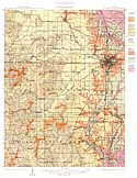
U.S. Geological Survey
Title/Description:
Glacial Map of Indiana
Publication Info:
Washington: Department of the Interior, U.S. Geological Survey, 1914; Monograph 53 Plate 6
Viewing Options
Main Author:
U.S. Geological Survey
Title/Description:
Topographic Map of Indiana
Publication Info:
Washington: Department of the Interior, U.S. Geological Survey, 1914; Monograph 53 Plate 3
Viewing Options
Main Author:
U.S. Geological Survey
Title/Description:
Map Showing thickness of drift in Indiana
Publication Info:
Washington: Department of the Interior, U.S. Geological Survey, 1914; Monograph 53 Plate 4
Viewing Options
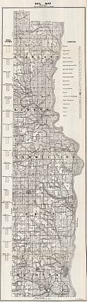
Main Author:
Coryell, H.N. and C.M. Rose
Title/Description:
Soil Map, Howard County
Publication Info:
Indianapolis: Indiana Department of Geology and Natural Resources, 1915; from the 39th Annual Report of 1914
Viewing Options
Main Author:
Department of Geology and Natural Resources
Title/Description:
Soil Map of Jay County
Publication Info:
Indianapolis: Indiana Department of Geology and Natural Resources, 1915; from the 39th Annual Report of 1914
Viewing Options
Main Author:
Rand McNally and Company
Title/Description:
Indiana
Publication Info:
Chicago: Rand McNally and Company, 1915; from The Ideal Atlas of the World
Viewing Options
Main Author:
Barrett, Edward
Title/Description:
Geological Map, Bloomington 15 minute Quadrangle
Publication Info:
Indianapolis: Department of Geology, 1915; from the 39th Annual Report of 1914
Viewing Options
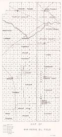
Main Author:
Department of Geology and Natural Resources
Title/Description:
Map of San Pierre Oil Field
Publication Info:
Indianapolis: Department of Geology and Natural Resources, 1915; from the 39th Annual Report

