Viewing Options
Viewing Options
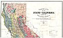
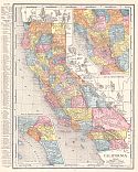
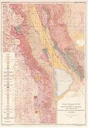
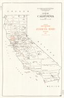
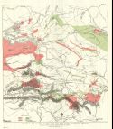
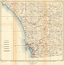
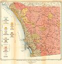
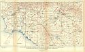
Main Author:
Smith, James Perrin
Title/Description:
Geological Map of the State of California
Publication Info:
California State Mining Bureau, 1916
Viewing Options
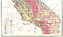
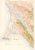
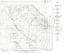
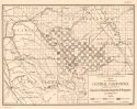
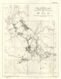
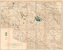
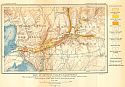
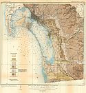
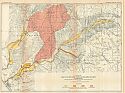
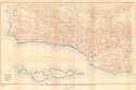
Main Author:
U.S. Geological Survey
Title/Description:
Geologic Map of Cuyama Valley, California
Publication Info:
Washington: Department of the Interior, U.S. Geological Survey, 1916; Bulletin 621 Plate XIX
Viewing Options
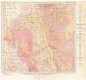
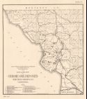
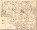
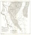
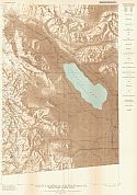
Main Author:
U.S. Geological Survey
Title/Description:
Map of Lower Colorado River showing irrigable lands below Cibila Valley
Publication Info:
Washington: Department of the Interior, U.S. Geological Survey, 1916; Bulletin 395 Plate 12
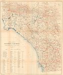
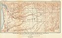
Viewing Options
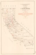
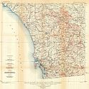
Main Author:
Rand McNally and Company
Title/Description:
California
Publication Info:
Chicago: Rand McNally and Company, 1916
Viewing Options
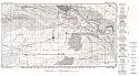
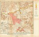
Main Author:
U.S. Geological Survey
Title/Description:
Map of a part of Southern California showing precipitation and gaging stations
Publication Info:
Washington: Department of the Interior, U.S. Geological Survey, 1917; Bulletin 426 Plate 1
Viewing Options
Main Author:
U.S. Department of the Interior, U.S. Geological Survey
Title/Description:
Point Reyes Quadrangle, California
Publication Info:
Washington: U.S. Department of the Interior, U.S. Geological Survey, 1918
Viewing Options
Main Author:
U.S. Geological Survey
Title/Description:
Geologic Reconnaissance Map of the Bishop Quadrangle and a part of the Mount Goddard Quadrangle, California
Publication Info:
Washington: U.S. Deparment of the Interior, Geological Survey
Viewing Options
Main Author:
U.S. Geological Survey
Title/Description:
Geologic Reconnaissance Map of the Mount Whitney Quadrangle and a parts of the Olancha and Ballarat Quadrangles, California
Publication Info:
Washington: U.S. Deparment of the Interior, Geological Survey
Viewing Options
Main Author:
U.S. Geological Survey
Title/Description:
Geologic Map of Middle Salinas Valley, California
Publication Info:
Washington: Department of the Interior, U.S. Geological Survey, 1918; Bulletin 691 Plate XXVII
Viewing Options
Main Author:
U.S. Geological Survey
Title/Description:
Geologic Map of Simi Valley, Ventura County and part of Los Angeles County, California
Publication Info:
Washington: Department of the Interior, U.S. Geological Survey, 1918; Bulletin 691 Plate XLI
Viewing Options
Main Author:
Hamilton, Fletcher
Title/Description:
Outline Map of California showing locations of Chromium and Magnesium Deposits
Publication Info:
San Francisco: California State Mining Bureau, 1918; from Bulletin No. 76
Viewing Options
Main Author:
Hamilton, Fletcher
Title/Description:
Map of a portion of Central California showing locations of deposits of Chromium, Magnesite and Manganese
Publication Info:
San Francisco: California State Mining Bureau, 1918; from Bulletin No. 76
Viewing Options
Main Author:
Hamilton, Fletcher
Title/Description:
Locations of Chrome ore deposits, San Luis Obispo Co., California
Publication Info:
San Francisco: California State Mining Bureau, 1918; from Bulletin No. 76
Viewing Options
Main Author:
California State Mining Bureau
Title/Description:
Outline Map of California Showing Locations of Quicksilver Deposits
Publication Info:
San Francisco: California State Mining Bureau, 1918; Bulletin No. 78
Viewing Options
Main Author:
McLaughlin, R.P.
Title/Description:
Geological Map of Portions of Napa, Sonoma and Lake Counties, California
Publication Info:
San Francisco: California State Mining Bureau, 1918; Bulletin No. 78, reprint of a 1903 map
Viewing Options
Main Author:
California State Mining Bureau
Title/Description:
Geological Map of Napa, Sonoma, lake and Yolo County Quicksilver Districts
Publication Info:
San Francisco: California State Mining Bureau, 1918; Bulletin No. 78, reprint from Bulletin 27
Viewing Options
Main Author:
California State Mining Bureau
Title/Description:
Map of New Almaden Mine, Santa Clara Co., Cal.
Publication Info:
San Francisco: California State Mining Bureau, 1918; Bulletin No. 78
Viewing Options
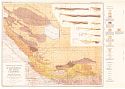
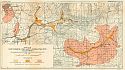
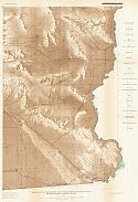
Main Author:
U.S. Geological Survey
Title/Description:
Geologic Map and Sections of the Sunset-Midway Oil Field and the North Flank of the San Emigdio Mountains
Publication Info:
Washington: U.S. Deparment of the Interior, Geological Survey
Viewing Options
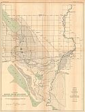
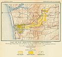
Main Author:
U.S. Geological Survey
Title/Description:
Map of San Jacinto and Temecula Basins, California, showing geologic formations, artesian basins, depths to water and wells
Publication Info:
Washington: Department of the Interior, U.S. Geological Survey, 1919; Bulletin 429 Plate 3
Viewing Options
Main Author:
U.S. Geological Survey
Title/Description:
Map of San Jacinto and Temecula Basins, California, showing irrgated lands, pumping plants, and principal distribution systems in 1915
Publication Info:
Washington: Department of the Interior, U.S. Geological Survey, 1919; Bulletin 429 Plate 5
Viewing Options
Main Author:
U.S. Gelogical Survey
Title/Description:
Map of San Jacinto and Temecula Basins, California, showing lands irrigated in 1904 and in 1915
Publication Info:
Washington: Department of the Interior, U.S. Geological Survey, 1919; Bulletin 429 Plate 6
Viewing Options
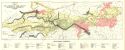
Main Author:
U.S. Geological Survey
Title/Description:
Topographic Map of part of La Jolla Quadrangle, California showing erosional features of Lindavista and Poway Terraces
Publication Info:
Washington: Department of the Interior, U.S. Geological Survey, 1919; Bulletin 446 Plate 8
Viewing Options
Main Author:
U.S. Geological Survey
Title/Description:
Map of Part of San Diego Bay Region, California showing principal water-bearing formations, contours of water table and tested pumping plants
Publication Info:
Washington: Department of the Interior, U.S. Geological Survey, 1919; Bulletin 446 Plate 20
Viewing Options
Main Author:
U.S. Geological Survey
Title/Description:
Map of Mission Valley, California showing principal water-bearing formations, contours of the water table, observation wells and tested punping plants
Publication Info:
Washington: Department of the Interior, U.S. Geological Survey, 1919; Bulletin 446 Plate 12
Viewing Options
Main Author:
U.S. Geological Survey
Title/Description:
Map of San Dieguito Valley, California, showing vallet fill and location of observation well and gaging station
Publication Info:
Washington: Department of the Interior, U.S. Geological Survey, 1919; Bulletin 446 Plate 23
Viewing Options
Main Author:
U.S. Geological Survey
Title/Description:
Map of San Pasqua and Santa Monica Valleys, California showing principal water-bearing formations and observation wells
Publication Info:
Washington: Department of the Interior, U.S. Geological Survey, 1919; Bulletin 446 Plate 4
Viewing Options
Main Author:
U.S. Geological Survey
Title/Description:
Map of the San Diego Area, California showing Topography and Location of Wells
Publication Info:
Washington: Department of the Interior, U.S. Geological Survey, 1919; Bulletin 446 Plate 2
Viewing Options
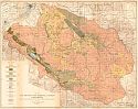
Main Author:
U.S. Geological Survey
Title/Description:
Preliminary Geologic Map of San Diego County, California
Publication Info:
Washington: Department of the Interior, U.S. Geological Survey, 1919; Bulletin 446 Plate 3
Viewing Options
Main Author:
U.S. Geological Survey
Title/Description:
Map of San Diego Quadrangle, California Showing Marine Terraces and Marine Soundings
Publication Info:
Washington: Department of the Interior, U.S. Geological Survey, 1919; Bulletin 440 Plate 6
Viewing Options
Main Author:
U.S. Geological Survey
Title/Description:
Map of western part of San Diego County, California showing precipitation and drainage areas above gaging stations
Publication Info:
Washington: Department of the Interior, U.S. Geological Survey, 1919; Bulletin 446 Plate 25
Viewing Options
Main Author:
U.S. Geological Survey
Title/Description:
Map of El Cajon Valley and Vicinity, California, showing principal water-bearing formations, observations and wells and tested pumping plants
Publication Info:
Washington: Department of the Interior, U.S. Geological Survey, 1919; Bulletin 446 Plate 22
Viewing Options
Main Author:
U.S. Geological Survey
Title/Description:
Map of San Luis Rey and Santa Margarita Valleys, California showing principal water-bearing formations and observation wells
Publication Info:
Washington: Department of the Interior, U.S. Geological Survey, 1919; Bulletin 446 Plate 25
Viewing Options
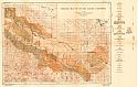
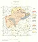
Main Author:
Hamilton, Fletcher
Title/Description:
Geological Map of Del Norte County, California
Publication Info:
San Francisco: California State Mining Bureau, 1919; Bulletin No. 85
Viewing Options
Title/Description:
Geological Map of the Central Part of Salmon River District, Siskiyou County, California
Publication Info:
San Francisco: California State Mining Bureau, 1919; Bulletin No. 85

Viewing Options
Main Author:
Reynolds, Francis J.
Title/Description:
California
Publication Info:
New York: P.F. Collier and Son Company, 1920; from The New World Atlas and Gazetteer
Viewing Options
Main Author:
Cram, George F.
Title/Description:
Yosemite National Park
Publication Info:
Chicago: James R. Gray and Company, 1920; from Cram's Unrivaled Atlas of the World
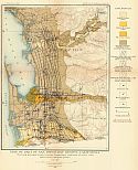
Viewing Options
Main Author:
U.S. Geological Survey
Title/Description:
Map of a part of Southern California showing location of observation wells and precipitation and steam-gaging stations for which records are given in this report
Publication Info:
Washington: Department of the Interior, U.S. Geological Survey, 1920; Bulletin 468 Plate 1
Viewing Options
Main Author:
U.S. Geological Survey
Title/Description:
Map of a part of Southern California showing gaging stations (Part A)
Publication Info:
Washington: Department of the Interior, U.S. Geological Survey, 1920; Bulletin 447 Plate 2

Viewing Options
Main Author:
U.S. Geological Survey
Title/Description:
Map of a part of Southern California showing gaging stations (Part B)
Publication Info:
Washington: Department of the Interior, U.S. Geological Survey, 1920; Bulletin 447 Plate 1
Viewing Options
Main Author:
U.S. Geological Survey
Title/Description:
Relief Map of the Western Part of the Salton Sea Region, California, showing desert watering places
Publication Info:
Washington: Department of the Interior, U.S. Geological Survey, 1920; Bulletin 497 Plate 2
Viewing Options
Main Author:
U.S. Geological Survey
Title/Description:
Relief map of the Eastern Part of the Salton Sea Region, California, showing desert watering places
Publication Info:
Washington: Department of the Interior, U.S. Geological Survey, 1920; Bulletin 497 Plate 3
Viewing Options
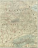
Main Author:
Clason Map Company
Title/Description:
Los Angeles
Publication Info:
Los Angeles: Clason Map Company, 1920
Original Source:
Murray Hudson

