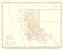
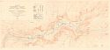
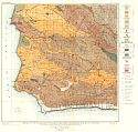
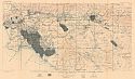
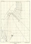
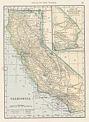
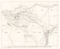
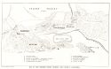
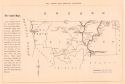
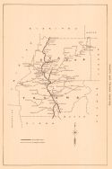
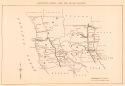
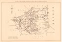
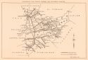
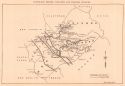
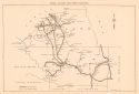
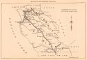
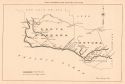
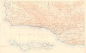
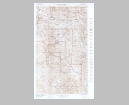
Viewing Options
Main Author:
U.S. Department of the Interior, U.S. Geological Survey
Title/Description:
Map of Nothern California, Showing Progress of Topographic Surveying and Primary Control
Publication Info:
Washington, D.C.: U.S. Department of the Interior, U.S.G.S. 1906; Twenty-Sixty Annual Report Pl. XV
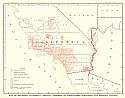
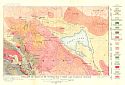
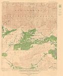
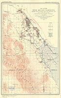
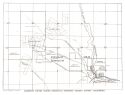
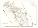
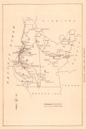
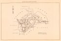
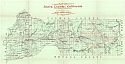
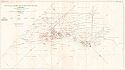
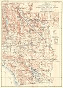
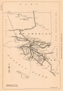
Viewing Options
Main Author:
U.S. Department of the Interior, U.S. Geological Survey
Title/Description:
Map of Suthern California Shwowing Progress of Topographic Surveying and Primary Control
Publication Info:
Washington, D.C.: U.S. Department of the Interior, U.S.G.S., 1906; Twenty-Sixth Annual Report Pl. XVI
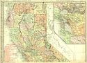
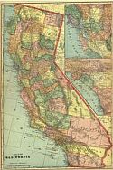
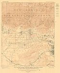
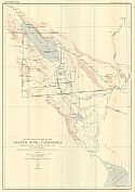
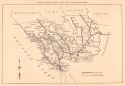
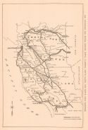
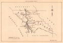
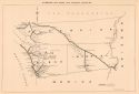
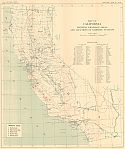
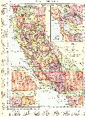
Viewing Options
Main Author:
Rand McNally and Company
Title/Description:
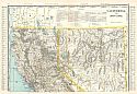
California (Northern Part)
Publication Info:
Chicago: Rand McNally and Company from the Business Atlas and Shippers Guide
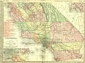
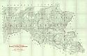
Viewing Options
Main Author:
Rand McNally and Company
Title/Description:
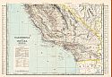
California (Southern Part)
Publication Info:
Chicago: Rand McNally and Company from the Business Atlas and Shippers Guide
Viewing Options
Main Author:
C.S. Hammond and Company
Title/Description:
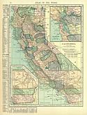
California
Publication Info:
New York: C.S. Hammond and Company, 1906; from the Pictorial Atlas of the World
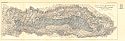
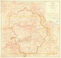
Viewing Options
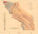
Main Author:
U.S. Geological Survey
Title/Description:
Geologic Map of the Santa Clara Valley and Adjacent Oil Fields, Ventura and Los Angeles Counties, California
Publication Info:
Washington: Department of the Interior, U.S. Geological Survey, 1906; Bulletin 309 Plate I
Viewing Options
Main Author:
Cram, George F.
Title/Description:
California and Nevada, Northern Half
Publication Info:
Chicago: George F. Cram for A. A. Grant, Toronto, Ont., 1906; from Grant's Bankers and Brokers Railroad System Atlas
Viewing Options
Main Author:
Cram, George F.
Title/Description:
California and Nevada, Southern Half
Publication Info:
Chicago: George F. Cram for A. A. Grant, Toronto, Ont., 1906; from Grant's Bankers and Brokers Railroad System Atlas
Viewing Options
Main Author:
U.S. Geological Survey
Title/Description:
Map of Yosemite Valley, Mariposa County, California
Publication Info:
Washington: U.S. Department of the Interior, U.S. Geological Survey, 1907
Viewing Options
Main Author:
Cram, George F.
Title/Description:
California
Publication Info:
Chicago: George F. Cram, 1907; from Cram's Standard American Atlas
Viewing Options
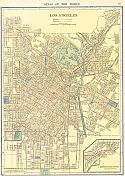
Main Author:
Cram, George F.
Title/Description:
Map of Los Angeles
Publication Info:
Chicago: George F. Cram, 1907; from Cram's Standard American Atlas
Viewing Options
Main Author:
P.F. Collier and Son
Title/Description:
California
Publication Info:
New York: P.F. Collier and Son, 1907; from The New Encyclopedic Atlas and Gazetteer of the World
Viewing Options
Main Author:
U.S. Geological Survey
Title/Description:
Preliminary Geologic and Structural Map of the Lompoc and Guadalupe Quadrangles, California including a large part of the Santa Maria Oil District
Publication Info:
Washington: Department of the Interior, U.S. Geological Survey, 1907; Bulletin 322, Plate I
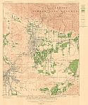
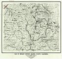
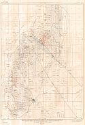
Viewing Options
Main Author:
U.S. Geological Survey
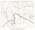
Title/Description:
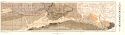
Topography and Geology of the Southern Half of Honey Lake Quadrangle, California
Publication Info:
Washington: Department of the Interior, U.S. Geological Survey, 1907; Bulletin 353 Plate II

Viewing Options
Main Author:
U.S. Geological Survey
Title/Description:
Topography and Geology of Area Covered by Indian Valley Map
Publication Info:
Washington: Department of the Interior, U.S. Geological Survey, 1907; Bulletin 353 Plate III
Viewing Options
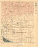
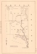
Main Author:
U.S. Geological Survey
Title/Description:
Map showing wells and artesian areas and water levels in the Cucamonga quadrangle, California
Publication Info:
Washington: Department of the Interior, U.S. Geological Survey, 1907; Bulletin 219 Plate 5
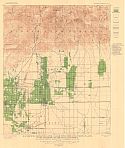
Viewing Options
Main Author:
U.S. Geological Survey
Title/Description:
Map showing irrigated lands, cnals, pipe lines, and pumping plants in the Cucamonga quadrangle, California
Publication Info:
Washington: Department of the Interior, U.S. Geological Survey, 1907; Bulletin 219 Plate 4
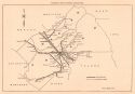
Viewing Options
Main Author:
U.S. Geological Survey
Title/Description:
Map showing the Artesian areas and hydrographic contours in the valley of Southern California
Publication Info:
Washington: Department of the Interior, U.S. Geological Survey, 1907; Bulletin 219 Plate 3
Viewing Options
Main Author:
U.S. Geological Survey
Title/Description:
Map showing irrigated lands, canals, pipe lines, and pumping plants in the Pomona quadrangle, California
Publication Info:
Washington: Department of the Interior, U.S. Geological Survey, 1907; Bulletin 219 Plate 6
Viewing Options
Main Author:
U.S. Geological Survey
Title/Description:
Map showing wells, artesian areas, and water levels in the Pomona quadrangle, California
Publication Info:
Washington: Department of the Interior, U.S. Geological Survey, 1907; Bulletin 219 Plate 7
Viewing Options
Main Author:
U.S. Geological Survey
Title/Description:
Map showing irrigated lands, canals, pipe lines, and pumping plants in the Pasadena quadrangle, California
Publication Info:
Washington: Department of the Interior, U.S. Geological Survey, 1907; Bulletin 219 Plate 8

Viewing Options
Main Author:
U.S. Geological Survey
Title/Description:
Map showing wells, artesian areas, and water levels in the Pasadena quadrangle, California
Publication Info:
Washington: Department of the Interior, U.S. Geological Survey, 1907; Bulletin 219 Plate 9
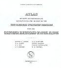
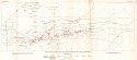
Viewing Options
Main Author:
State Earthquake Investigation Commission
Title/Description:
Atlas of Maps and Seismograms Accompanying the Report of the State Earthquake Investigation Commission upon the California Earthquake of April 18, 1906
Publication Info:
Washington D.C.: Carnegie Institution, 1908
Viewing Options
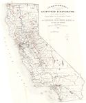
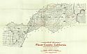
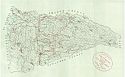
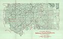
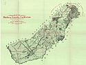
Main Author:
Punnett Brothers
Title/Description:
Map of Plumas County, California
Publication Info:
San Fransisco: Punnett Brothers, 1908
Viewing Options
Main Author:
Mast, Crowell and Kirkpatrick
Title/Description:
California and Nevada
Publication Info:
New York: The Crowell Publishing Company, 1908; from The 20th Century Peerless Atlas
Viewing Options
Main Author:
U.S. Geological Survey
Title/Description:
Preliminary Geologic and Structural Map of the Coaling District, California
Publication Info:
Washington: Department of the Interior, U.S. Geological Survey, 1908; Bulletin 357 Plate I
Viewing Options
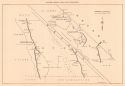
Main Author:
U.S. Geological Survey
Title/Description:
Structural Contour Map of the Coalinga Field
Publication Info:
Washington: Department of the Interior, U.S. Geological Survey, 1908; Bulletin 357 Plate II
Viewing Options
Main Author:
U.S. Geological Survey
Title/Description:
Map of the Indio Region, California showing wells, artesian area and irrigated land
Publication Info:
Washington: Department of the Interior, U.S. Geological Survey, 1908; Bulletin 225 Plate 12
Viewing Options
Main Author:
U.S. Geological Survey
Title/Description:
Reconnaissance Map of the Salton Sink, California
Publication Info:
Washington: Department of the Interior, U.S. Geological Survey, 1908; Bulletin 225 Plate 1
Viewing Options
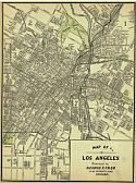
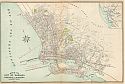
Main Author:
Hammond, C.S.
Title/Description:
Los Angeles
Publication Info:
New York: C.S. Hammond and Company, 1908
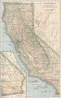
Viewing Options
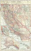
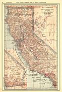
Main Author:
Hammond, C.S.
Title/Description:
California
Publication Info:
New York: C.S. Hammond & Co. 1908; from Hammond's Handy Atlas of the World
Viewing Options
Main Author:
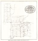
Aubury, Lewis E.
Title/Description:
Map of California showing the approximate location of the principal Copper Deposits of the State
Publication Info:
San Francisco: California State Mining District, 1908; from Bulletin No. 50
Viewing Options
Main Author:
Aubury, Lewis E.
Title/Description:
Map of a Portion of the Shasta County Copper Belt East of the Sacramento River, including the Bully Hill District, showing the principal mining properties
Publication Info:
San Francisco: California State Mining District, 1908; from Bulletin No. 50
Viewing Options
Main Author:
Aubury, Lewis E.
Title/Description:
Map of the Shasta Copper Belt west of the Sacramento River, showing principal mining properties
Publication Info:
San Francisco: California State Mining District, 1908; from Bulletin No. 50
Viewing Options
Main Author:
Aubury, Lewis E.
Title/Description:
Balaklala Consolidated Copper Company and adjoining property, Shasta County, California
Publication Info:
San Francisco: California State Mining District, 1908; from Bulletin No. 50
Viewing Options
Main Author:
Aubury, Lewis E.
Title/Description:
Mammoth Copper Mining Company's Property, Shasta County, California
Publication Info:
San Francisco: California State Mining District, 1908; from Bulletin No. 50
Viewing Options
Main Author:
Aubury, Lewis E.
Title/Description:
Copper Belt of Northern Siskiyou County, California
Publication Info:
San Francisco: California State Mining District, 1908; from Bulletin No. 50
Viewing Options
Main Author:
Aubury, Lewis E.
Title/Description:
Green Mountain Group of Mining Claims, Mariposa County
Publication Info:
San Francisco: California State Mining District, 1908; from Bulletin No. 50
Viewing Options
Main Author:
Aubury, Lewis E.
Title/Description:
Map of the Ubehebe Mining Districts, Inyo County, California
Publication Info:
San Francisco: California State Mining District, 1908; from Bulletin No. 50
Viewing Options
Main Author:
Aubury, Lewis E.
Title/Description:
Map of Mining District in immediate vicinity of Greenwater, Inyo County, California
Publication Info:
San Francisco: California State Mining District, 1908; from Bulletin No. 50
Viewing Options
Main Author:
California State Mining Bureau
Title/Description:
Map of Minaret District, Madera County, California
Publication Info:
San Francisco: State Mining Bureau, 1908
Viewing Options
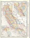
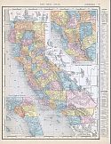
Main Author:
Rand McNally and Company
Title/Description:
California
Publication Info:
Chicago: Rand McNally and Company, 1908; from the New Ideal State and County Survey and Atlas
Viewing Options
Title/Description:
Map of Sacremento
Publication Info:
Sacremento: R.J. Squires, 1909; prepared expressly for the Sacremento Directory Co., blue print copy of original; 23283; USA
Viewing Options
Main Author:
Patten, William and J.E. Homas
Title/Description:
California
Publication Info:
New York: P.F. Collier and Son, 1909; from The New Encyclopedic Atlas and Gazetteer of the World
Viewing Options
Main Author:
Cram, George F.
Title/Description:
California
Publication Info:
Chicago: George F. Cram, c.1909; from the Heart of our Country
Viewing Options
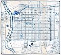
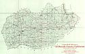
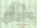
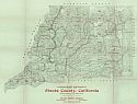
Main Author:
California State Mining Bureau
Title/Description:
Map of El Dorado County, California Showing Boundaries of the National Forests
Publication Info:
San Francisco: State Mining Bureau, 1909
Viewing Options
Main Author:
Aubury, Lewis E.
Title/Description:
Del Norte and Siskiyou Counties
Publication Info:
San Francisco: California State Mining District, 1909; from Bulletin No. 56
Viewing Options
Main Author:
California State Mining Bureau
Title/Description:
Map of Placer County, California Showing Boundaries of the National Forests
Publication Info:
San Francisco: State Mining Bureau, 1909
Viewing Options
Main Author:
Aubury, Lewis E.
Title/Description:
Modoc and Lassen Counties
Publication Info:
San Francisco: California State Mining District, 1909; from Bulletin No. 56
Viewing Options
Main Author:
California State Mining Bureau
Title/Description:
County of Calaveras, California
Publication Info:
San Francisco: State Mining Bureau, 1909
Viewing Options
Main Author:
Aubury, Lewis E.
Title/Description:
Shasta and Tehama Counties
Publication Info:
San Francisco: California State Mining District, 1909; from Bulletin No. 56
Viewing Options
Main Author:
California State Mining Bureau
Title/Description:
Map of Siskiyou County, California Showing Boundaries
Publication Info:
San Francisco: State Mining Bureau, 1909
Viewing Options
Main Author:
Aubury, Lewis E.
Title/Description:
Humboldt and Trinity Counties
Publication Info:
San Francisco: California State Mining District, 1909; from Bulletin No. 56
Viewing Options
Main Author:
California State Mining Bureau
Title/Description:
Map of Tuolumne County, California Showing Boundaries of National Forests
Publication Info:
San Francisco: State Mining Bureau, 1909
Viewing Options
Main Author:
Aubury, Lewis E.
Title/Description:
Mendocino, Glenn, Lake and Colusa Counties
Publication Info:
San Francisco: California State Mining District, 1909; from Bulletin No. 56
Viewing Options
Main Author:
California State Mining Bureau
Title/Description:
Map of Madera County, California Showing Boundaries of National Forests
Publication Info:
San Francisco: State Mining Bureau, 1909
Viewing Options
Main Author:
Aubury, Lewis E.
Title/Description:
Butte and Plumas Counties
Publication Info:
San Francisco: California State Mining District, 1909; from Bulletin No. 56
Viewing Options
Main Author:
California State Mining Bureau
Title/Description:
Map of Shasta County, California Showing Boundaries of National Forests
Publication Info:
San Francisco: State Mining Bureau, 1909
Viewing Options
Main Author:
Aubury, Lewis E.
Title/Description:
Sutter, Yuba, Sierra, Nevada, Placer, and El Dorado Counties
Publication Info:
San Francisco: California State Mining District, 1909; from Bulletin No. 56
Viewing Options
Main Author:
California State Mining Bureau
Title/Description:
Map of Sierra County, California Showing Boundaries of National Forests
Publication Info:
San Francisco: State Mining Bureau, 1909
Viewing Options
Main Author:
Aubury, Lewis E.
Title/Description:
Sonoma, Marin, Napa, Yolo, and Salano Counties
Publication Info:
San Francisco: California State Mining District, 1909; from Bulletin No. 56
Viewing Options
Main Author:
California State Mining Bureau
Title/Description:
Map of Trinity County, California Showing Boundaries of National Forests
Publication Info:
San Francisco: State Mining Bureau, 1909
Viewing Options
Main Author:
Aubury, Lewis E.
Title/Description:
Sacramento, San Joaquin, Amador and Calaveras Counties
Publication Info:
San Francisco: California State Mining District, 1909; from Bulletin No. 56
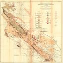
Viewing Options
Main Author:
U.S. Geological Survey
Title/Description:
Geologic and Structural Map of the Coalinga District, California
Publication Info:
Washington: Department of the Interior, U.S. Geological Survey, 1909; Bulletin 398 Plate I
Viewing Options
Main Author:
Aubury, Lewis E.
Title/Description:
San Francisco, San Mateo, Contra Costa, Alameda, Santa Clara and Santa Cruz Counties
Publication Info:
San Francisco: California State Mining District, 1909; from Bulletin No. 56
Viewing Options
Main Author:
U.S. Geological Survey
Title/Description:
Geologic and Topographic Map of the Coalinga Oil Field, Fresno County, California
Publication Info:
Washington: Department of the Interior, U.S. Geological Survey, 1909; Bulletin 398 Plate XV
Viewing Options
Main Author:
Aubury, Lewis E.
Title/Description:
Stanislaus, Merced, Tuolumne and Mariposa Counties
Publication Info:
San Francisco: California State Mining District, 1909; from Bulletin No. 56
Viewing Options
Main Author:
U.S. Geological Survey
Title/Description:
Structural Contour Map of the Sunset Oil Field, California
Publication Info:
Washington: Department of the Interior, U.S. Geological Survey, 1909; Bulletin 406 Plate iv
Viewing Options
Main Author:
Aubury, Lewis E.
Title/Description:
Madera and Fresno Counties
Publication Info:
San Francisco: California State Mining District, 1909; from Bulletin No. 56
Viewing Options
Main Author:
U.S. Geological Survey
Title/Description:
Structural Contour Map of the Midway Oil Field, California
Publication Info:
Washington: Department of the Interior, U.S. Geological Survey, 1909; Bulletin 406 Plate III
Viewing Options
Main Author:
Aubury, Lewis E.
Title/Description:
Kings, Tulare, and Kern Counties
Publication Info:
San Francisco: California State Mining District, 1909; from Bulletin No. 56
Viewing Options
Main Author:
U.S. Geological Survey
Title/Description:
Structural Contour Map of the McKittrick Oil Field, California
Publication Info:
Washington: Department of the Interior, U.S. Geological Survey, 1909; Bulletin 406 Plate II
Viewing Options
Main Author:
Aubury, Lewis E.
Title/Description:
Alpine, Mono and Inyo Counties
Publication Info:
San Francisco: California State Mining District, 1909; from Bulletin No. 56
Viewing Options
Main Author:
U.S. Geological Survey
Title/Description:
Preliminary Geologic and Structural Map of the McKittrick-Sunset Oil Region, California
Publication Info:
Washington: Department of the Interior, U.S. Geological Survey, 1909; Bulletin 406 Plate I
Viewing Options
Main Author:
Aubury, Lewis E.
Title/Description:
San Benito and Monterey Counties
Publication Info:
San Francisco: California State Mining District, 1909; from Bulletin No. 56
Viewing Options
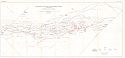
Main Author:
U.S. Geological Survey
Title/Description:
General Map showing approximate location of better known springs and wells in the Mohave and adjacent deserts Southeastern California and Southwestern Nevada
Publication Info:
Washington: Department of the Interior, U.S. Geological Survey, 1909; Bulletin 224 Plate 1
Viewing Options
Main Author:
Aubury, Lewis E.
Title/Description:
San Luis Obispo County
Publication Info:
San Francisco: California State Mining District, 1909; from Bulletin No. 56
Viewing Options
Main Author:
U.S. Geological Survey
Title/Description:
Artesian Areas and Groundwater levels in the San Joaquin Valley, California
Publication Info:
Washington: Department of the Interior, U.S. Geological Survey, 1909; Bulletin 222 Plate 1
Viewing Options
Main Author:
Aubury, Lewis E.
Title/Description:
Santa Barbara and Ventura Counties
Publication Info:
San Francisco: California State Mining District, 1909; from Bulletin No. 56
Viewing Options
Main Author:
Aubury, Lewis E.
Title/Description:
Los Angeles and Orange Counties
Publication Info:
San Francisco: California State Mining District, 1909; from Bulletin No. 56

Viewing Options
Main Author:
Aubury, Lewis E.
Title/Description:
San Bernardino County
Publication Info:
San Francisco: California State Mining District, 1909; from Bulletin No. 56
Viewing Options
Main Author:
Aubury, Lewis E.
Title/Description:
Riverside, San Diego and Imperial Counties
Publication Info:
San Francisco: California State Mining District, 1909; from Bulletin No. 56
Viewing Options
Main Author:
U.S. Geological Survey
Title/Description:
Administrative Map of Yosemite National Park, California
Publication Info:
Washington: U.S. Department of the Interior, U.S. Geological Survey, 1910
Viewing Options
Main Author:
U.S. Geological Survey
Title/Description:
Southern California - Sheet 3
Publication Info:
Washington: U.S. Department of the Interior, U.S. Geological Survey, 1910
Viewing Options
Main Author:
Cram, George F.
Title/Description:
Map of the City of Oakland, Berkeley and Alameda
Publication Info:
Berkeley: Ellis A. Davis, 1910; from Davis' Commercial Encyclopedia- California, Nevada, Utah and Arizona
Viewing Options
Main Author:
U.S. Geological Survey
Title/Description:
Map of California Showing drainage Areas and Locations of Sampling Stations
Publication Info:
Washington: Department of the Interior, U.S. Geological Survey, 1910; Bulletin 237 Plate 1
Viewing Options
Main Author:
Rand McNally and Company
Title/Description:
California
Publication Info:
Chicago: Rand McNally and Company, 1910
Viewing Options
Main Author:
U.S. Geological Survey
Title/Description:
Sequoia and General Grant National Parks
Publication Info:
Washington: Department of the Interior, U.S. Geological Survey, 1910
Original Source:
Geological Survey of Alabama
Viewing Options
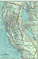
Main Author:
C.S. Hammond and Company
Title/Description:
California
Publication Info:
New York: C.S. Hammond and Company,1910; from The New Reference Atlas of the World

