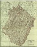
Viewing Options
Main Author:
West Virginia Geological Survey
Title/Description:
Map I of Hampshire County Showing Topography
Publication Info:
Morgantown: West Virginia Geological Survey, 1926
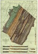
Viewing Options
Main Author:
West Virginia Geological Survey
Title/Description:
Map II of Hampshire County Showing General and Economic Geology
Publication Info:
Morgantown: West Virginia Geological Survey, 1926
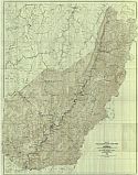
Viewing Options
Main Author:
West Virginia Geological Survey
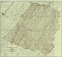
Title/Description:
Map II of Hardy County Showing Topography
Publication Info:
Morgantown: West Virginia Geological Survey, 1926
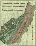
Viewing Options
Main Author:
West Virginia Geological Survey
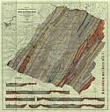
Title/Description:
Map IV of Hardy County Showing General and Economic Geology
Publication Info:
Morgantown: West Virginia Geological Survey, 1926
Viewing Options
Main Author:
West Virginia Geological Survey
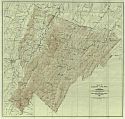
Title/Description:
Map I of Pendleton County Showing Topography
Publication Info:
Morgantown: West Virginia Geological Survey, 1927
Viewing Options
Main Author:
West Virginia Geological Survey
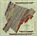
Title/Description:
Map II of Pendleton County Showing General and Economic Geology
Publication Info:
Morgantown: West Virginia Geological Survey, 1927

Viewing Options
Main Author:
Clason Map Company
Title/Description:
Best Roads of West Virginia
Publication Info:
Chicago: Clason Map Company, c. 1927; from Clason's Touring Atlas
Viewing Options
Main Author:
West Virginia Geological Survey
Title/Description:
Map I of Pocohontas County Showing Topography
Publication Info:
Morgantown: West Virginia Geological Survey, 1929
Viewing Options
Main Author:
West Virginia Geological Survey
Title/Description:
Map II of Pocohontas County Showing General and Economic Geology
Publication Info:
Morgantown: West Virginia Geological Survey, 1929

Viewing Options
Main Author:
West Virginia Geological Survey
Title/Description:
Map 1 of Randolph County showing Topography
Publication Info:
Morgantown: West Virginia Geological Survey, 1930

Viewing Options
Main Author:
National Map Company
Title/Description:
West Virginia
Publication Info:
Indianapolis: National Map Company, 1930; from Official Paved Road and Commercial Survey of the United States

Viewing Options
Main Author:
C.S. Hammond and Company
Title/Description:
West Virginia
Publication Info:
New York: C.S. Hammond and Company, c. 1930; from The New World Loose Leaf Atlas, Sixth Edition

Viewing Options
Main Author:
C.S. Hammond and Company
Title/Description:
West Virginia
Publication Info:
New York: C.S. Hammond and Company, c. 1930; from The New World Loose Leaf Atlas, Sixth Edition

