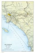
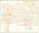
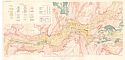
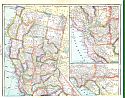
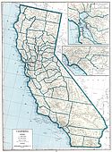
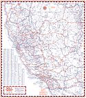
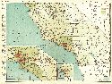
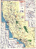
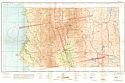
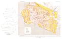
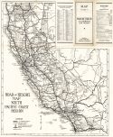
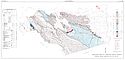
Viewing Options
Main Author:
Union Pacific System
Title/Description:
Los Angeles and Vicinity
Publication Info:
Omaha: Union Pacific System, 1926; from a promotional booklet titled California
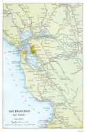
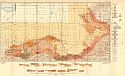
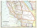
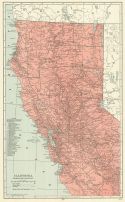
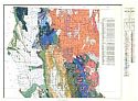
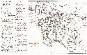
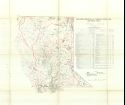
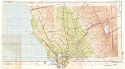
Viewing Options
Main Author:
Union Pacific System
Title/Description:
San Francisco and Vicinity
Publication Info:
Omaha: Union Pacific System, 1926; from a promotional booklet titled California
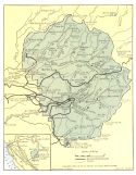
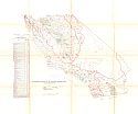
Viewing Options
Main Author:
Union Pacific System
Title/Description:
Yosemite National Park
Publication Info:
Omaha: Union Pacific System, 1926; from a promotional booklet titled California
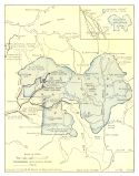
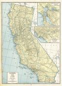
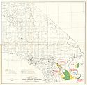
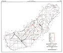
Viewing Options
Main Author:
Union Pacific System
Title/Description:
Sequoia and General Grant National Parks
Publication Info:
Omaha: Union Pacific System, 1926; from a promotional booklet titled California
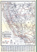
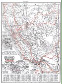
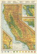
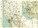
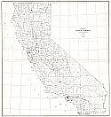
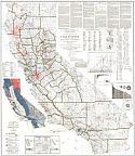
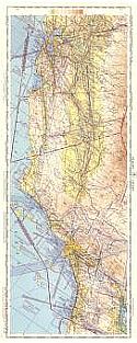
Viewing Options
Main Author:
Clason Map Company
Title/Description:
Best Roads of California and Nevada
Publication Info:
Chicago: Clason Map Company, c. 1927; from Clason's Touring Atlas
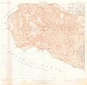
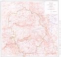
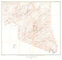
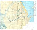
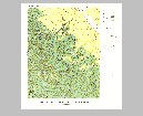
Viewing Options
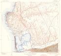
Main Author:
U.S. Department of the Interior, U.S. Geological Survey
Title/Description:
San Padro Hills Quadrangle, Los Angles County, California
Publication Info:
Washington: U.S. Department of the Interior, U.S. Geological Survey, 1928
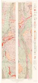
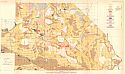
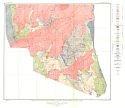
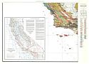
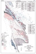
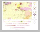
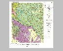
Viewing Options
Main Author:
U.S. Geological Survey
Title/Description:
Geologic Map of the Mother Lode Belt, California
Publication Info:
Washington: U.S. Deparment of the Interior, Geological Survey
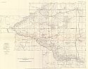
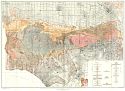
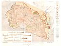
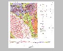
Viewing Options
Main Author:
U.S. Geological Survey
Title/Description:
Map of Antelope Valley showing boundary of drainage basin and location of springs, wells, and area of artesian flow
Publication Info:
Washington: Department of the Interior, U.S. Geological Survey, 1928; Bulletin 578 Plate 10
Viewing Options
Main Author:
U.S. Department of the Interior, U.S. Geological Survey
Title/Description:
Lassen Volcanic National Park, California
Publication Info:
Washington: U.S. Department of the Interior, U.S. Geological Survey, 1929
Viewing Options
Main Author:
U.S. Geological Survey
Title/Description:
Reconnaissance Geologic Map of the Mohave Desert Region
Publication Info:
Washington: Department of the Interior, U.S. Geological Survey, 1928; Bulletin 578 Plate 8
Viewing Options
Main Author:
U.S. Geological Survey
Title/Description:
Map of the Mohave Desert Region showing boundaries of drainage basins and character of playas
Publication Info:
Washington: Department of the Interior, U.S. Geological Survey, 1928; Bulletin 578 Plate 7
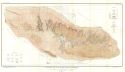
Viewing Options
Main Author:
U.S. Geological Survey
Title/Description:
Topgraphic Map of the Yosemite National Park, California
Publication Info:
Washington: U.S. Deparment of the Interior, Geological Survey
Viewing Options
Main Author:
U.S. Geological Survey
Title/Description:
Map of Glacial and Postglacial Deposits in Yosemite Valley, Mariposa, California
Publication Info:
Washington: U.S. Deparment of the Interior, Geological Survey
Viewing Options
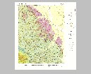
Main Author:
U.S. Geological Survey
Title/Description:
Geologic Map and Sections of the Foothills along the Southern and Southeastern border of San Joaquin Valley, Kern County, California
Publication Info:
Washington: Department of the Interior, U.S. Geological Survey, 1930; Bulletin 812 Plate 31
Viewing Options
Main Author:
U.S. Geological Survey
Title/Description:
Map of Mokelumne Area, California, showing ground-water contours, depth to ground water in July 1929 and location of oberservation wells
Publication Info:
Washington: Department of the Interior, U.S. Geological Survey, 1930; Bulletin 619 Plate 8
Viewing Options
Main Author:
U.S. Geological Survey
Title/Description:
Map showing Areas Irrigated by wells, river pumping plants, and gravity diversions and the location of the pumping plants on wells on the Mokelumne River, California
Publication Info:
Washington: Department of the Interior, U.S. Geological Survey, 1930; Bulletin 619 Plate 5
Viewing Options
Main Author:
National Map Company
Title/Description:
California - North
Publication Info:
Indianapolis: National Map Company, 1930; from Official Paved Road and Commercial Survey of the United States
Viewing Options
Main Author:
National Map Company
Title/Description:
California - South
Publication Info:
Indianapolis: National Map Company, 1930; from Official Paved Road and Commercial Survey of the United States
Viewing Options
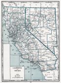
Main Author:
Clason Map Company
Title/Description:
Clason's Road Map of California and Nevada
Publication Info:
Denver: The Clason Map Company, 1930; from Clason's Touring Atlas of the United States and Canada
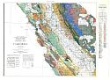
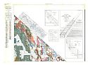
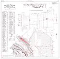
Viewing Options
Title/Description:
Geologic Map of the Eastern part of the Santa Monica Mountains and adjacent areas, Los Angeles County, California
Publication Info:
Washington D.C.: Department of the Interior, US Geological Survey, 1931; Professional Paper 165, plate 16
Viewing Options
Main Author:
Geographical Publishing Company
Title/Description:
California
Publication Info:
Chicago: Geographical Publishing Company1931; from Commercial Atlas of the World
Viewing Options
Main Author:
C.S. Hammond and Company
Title/Description:
California (North and Central Part)
Publication Info:
New York: C.S. Hammond and Company, c. 1930; from The New World Loose Leaf Atlas, Sixth Edition
Viewing Options
Main Author:
C.S. Hammond and Company
Title/Description:
California (Southern Part)
Publication Info:
New York: C.S. Hammond and Company, c. 1930; from The New World Loose Leaf Atlas, Sixth Edition
Viewing Options
Main Author:
C.S. Hammond and Company
Title/Description:
California
Publication Info:
New York: C.S. Hammond and Company, c. 1930; from The New World Loose Leaf Atlas, Sixth Edition
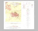
Viewing Options
Title/Description:
Map of the Alleghany District, California, Showing the Principal Mine Works
Publication Info:
Washington D.C.: Department of the Interior, US Geological Survey, 1932; Professional paper 172, Plate 9
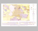
Viewing Options
Title/Description:
Geologic Map of the Alleghany District, California, Showing Principal Mining Claims
Publication Info:
Washington D.C.: Department of the Interior, US Geological Survey, 1932; Professional Paper 172, Plate 1
Viewing Options
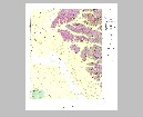
Main Author:
U.S. Geological Survey
Title/Description:
Geologic Map of the Elk Mountains
Publication Info:
Washington: Department of the Interior, U.S. Geological Survey, 1932; Bulletin 835 Plate 1
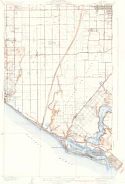
Viewing Options
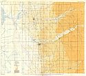
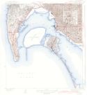
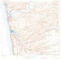
Main Author:
U.S. Department of the Interior, U.S. Geological Survey
Title/Description:
Newport Beach Quadrangle, Orange County, California
Publication Info:
Washington: U.S. Department of the Interior, U.S. Geological Survey, 1935
Viewing Options
Main Author:
H.M. Gousha Company
Title/Description:
Guide "A" Index Map of California, Nevada
Publication Info:
Chicago: H.M. Gousha Company, 1935; from Gousha Guide, Guide A
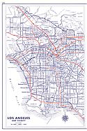
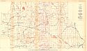
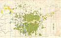
Viewing Options
Main Author:
H.M. Gousha Company
Title/Description:
Los Angeles and Vicinity
Publication Info:
Chicago: H.M. Gousha Company, 1935; from Gousha Guide, Guide A
Viewing Options
Main Author:
Branom, Frederick K. and Lloyd Edwin Smith
Title/Description:
California and Nevada
Publication Info:
Chicago: Geographical Publishing Company, 1936; from Capper's 1936 Atlas of the World
Viewing Options
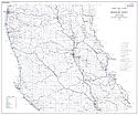
Main Author:
Rand McNally and Company
Title/Description:
Northern California
Publication Info:
Chicago: Rand McNally and Company, 1936
Viewing Options
Main Author:
Rand McNally and Company
Title/Description:
Southern California
Publication Info:
Chicago: Rand McNally and Company, 1936
Viewing Options
Viewing Options
Viewing Options
Viewing Options
Viewing Options
Viewing Options
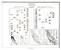
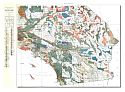
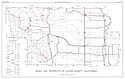
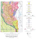
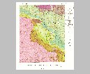
Main Author:
Jenkins, Olaf P.
Title/Description:
Geological Map of California
Publication Info:
State of California, Department of Natural Resources, Division of Mines
Viewing Options
Main Author:
U.S. Geological Survey
Title/Description:
Geologic and Hydrologic Map of the Mokelumne Area, California
Publication Info:
Washington: Department of the Interior, U.S. Geological Survey, 1938; Water Supply Paper No. 780 Plate 1
Viewing Options
Title/Description:
Touring Map of California
Publication Info:
Chicago: Rand McNally and Company, 1938
Original Source:
Murray Hudson
Viewing Options
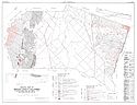
Main Author:
Board of Supervisors of Los Angeles County
Title/Description:
Los Angeles County, California
Publication Info:
Los Angeles: Clason Map Company, 1938
Original Source:
Murray Hudson
Viewing Options
Main Author:
U.S. Geological Survey
Title/Description:
State of California
Publication Info:
Washington, D.C.: Department of the Interior, U.S. Geological Survey, 1940; reprinted 1944
Viewing Options
Main Author:
U.S. Department of the Interior, U.S. Geological Survey
Title/Description:
Point Loma Quadrangle, San Diego County, California
Publication Info:
Washington: U.S. Department of the Interior, U.S. Geological Survey, 1942
Viewing Options
Main Author:
U.S. Coast and Geodetic Survey
Title/Description:
Mt. Shasta Sectional Aeronautical Chart
Publication Info:
Washington: U.S. Coast and Geodetic Survey, 1942
Viewing Options
Main Author:
Bureau of the Census
Title/Description:
California Irrigation by Drainage Basins, 1939 (Northern Part)
Publication Info:
Washington: U.S. Government Printing Office, 1942
Viewing Options
Main Author:
Bureau of the Census
Title/Description:
California Irrigation by Drainage Basins, 1939 (Southern Part)
Publication Info:
Washington: U.S. Government Printing Office, 1942
Viewing Options
Main Author:
Geographical Publishing Company
Title/Description:
California
Publication Info:
Chicago: Geographical Publishing Company, 1942; from The New International Atlas of The World, War Edition
Viewing Options
Main Author:
U.S. Department of the Interior, U.S. Geological Survey
Title/Description:
La Jolla Quadrangle, San Diego County, California
Publication Info:
Washington: U.S. Department of the Interior, U.S. Geological Survey, 1943
Viewing Options
Main Author:
U.S. Department of the Interior, U.S. Geological Survey
Title/Description:
Del Mar Quadrangle, San Diego County, California
Publication Info:
Washington: U.S. Department of the Interior, U.S. Geological Survey, 1943
Viewing Options
Main Author:
Jenkins, Olaf P.
Title/Description:
Outline Geologic Map of California Showing Locations of Manganese Properties
Publication Info:
Sacramento: State of California Department of Natural Resources, Division of Mines, 1943
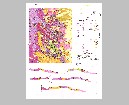
Viewing Options
Title/Description:
Geologic Map and Sections of Palos Verdes Hills, Los Angeles County, California
Publication Info:
Washington D.C.: Department of the Interior, US Geological Survey, 1946; Professional paper 207, Plate 1
Viewing Options
Title/Description:
Topographic Map of Palos Verdes Hills, Los Angeles County, California, Showing Distribution and Designation of Pleistocene Marine Terraces and Terrace Profiles
Publication Info:
Washington D.C.: Department of the Interior, US Geological Survey, 1946; Professional Paper 207, Plate 22
Viewing Options
Main Author:
U.S. Coast and Geodetic Survey
Title/Description:
Sacramento Sectional Aeronautical Chart
Publication Info:
Washington: U.S. Coast and Geodetic Survey, 1946
Viewing Options
Main Author:
U.S. Department of the Interior
Title/Description:
Water Resources Development, Colorado Basin, Califorinia
Publication Info:
Washington: U.S. Department of the Interior, Bureau of Reclamation, 1946; from The Colorado River, A Natural Menace Becomes a Natural Resource
Viewing Options
Main Author:
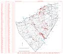
Department of Natural Resources, Division of Mines
Title/Description:
Map of Stanislaus County California Showing Locations of Principal Mineral Deposits
Publication Info:
Sacramento: Department of Natural Resources, Division of Mines, 1946; from Journal Vol. 43, Plate 15
Viewing Options
Title/Description:
(Death Valley)
Publication Info:
from an advertising brochure for the Death Valley Hotel Company, Ltd.
Viewing Options
Title/Description:
Road and Resort Map South Pacific Coast Region
Publication Info:
Issued by the Whittier, California Chamber of Commerce, c.1948
Viewing Options
Main Author:
Redwood Empire Association
Title/Description:
Redwood Empire All-Year Routes
Publication Info:
San Francisco: Redwood Empire Association, 1948
Original Source:
Murray Hudson
Viewing Options
Main Author:
Department of Natural Resources, Division of Mines
Title/Description:
Map of Madera County Showing Location of Mines and Mineral Deposits
Publication Info:
Sacramento: Department of Natural Resources, Division of Mines, 1950; from Journal Vol. 46, Plate 73
Viewing Options
Main Author:
U.S. Coast and Geodetic Survey
Title/Description:
Flight Chart: San Diego to San Francisco, U.S.A. (FC-220)
Publication Info:
Washington, D.C.: U.S. Coast and Geodetic Survey, 1952; 8th Edition
Viewing Options
Main Author:
Department of Natural Resources, Division of Mines
Title/Description:
Geologic Map of Merced County, California Showing Mines, Sand and Gravel Pits and Holes Drilled for Oil
Publication Info:
Sacramento: Department of Natural Resources, Division of Mines, 1952; from Journal Vol. 48, No. 3, Pl. 12
Viewing Options
Main Author:
Department of Natural Resources, Division of Mines
Title/Description:
Mines and Prospects of Glenn County, California
Publication Info:
Sacramento: Department of Natural Resources, Division of Mines, 1952; from Journal Vol. 48, No. 1, Pl. 1
Viewing Options
Main Author:
U.S. Geological Survey
Title/Description:
Geologic Map and Structure of the Gasquet Quadrangle, California
Publication Info:
Washington: Department of the Interior, U.S. Geological Survey, 1953; Bulletin No. 995
Viewing Options
Main Author:
Department of Natural Resources, Division of Mines
Title/Description:
Mines and Claims of Mendocino County [North Half]
Publication Info:
Sacramento: Department of Natural Resources, Division of Mines, 1953; from Journal Vol. 49, No. 4, Plate 10a
Viewing Options
Main Author:
Department of Natural Resources, Division of Mines
Title/Description:
Mines and Claims of Mendocino County [South Half]
Publication Info:
Sacramento: Department of Natural Resources, Division of Mines, 1953; from Journal Vol. 49, No. 4, Plate 10b
Viewing Options
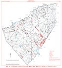
Main Author:
Department of Natural Resources, Division of Mines
Title/Description:
Geologic Map of Kings County, California Showing Mines and Holes Drilled for Oil and Gas
Publication Info:
Sacramento: Department of Natural Resources, Division of Mines, 1953; from Journal Vol. 49, No. 3, Pl. 4
Viewing Options
Main Author:
Department of Natural Resources, Division of Mines
Title/Description:
Geologic Map of San Mateo County, California, Showing the Location of Mineral Product Operations
Publication Info:
Sacramento: Department of Natural Resources, Division of Mines, 1955; from Journal Vol. 51, No. 4, Plate 5
Viewing Options
Main Author:
Department of Natural Resources, Division of Mines
Title/Description:
Geologic Map of San Joaquin County Showing Mines, Gas Fields and Holes Drilled for Gas Aggregate Pits and Clay Products Plants
Publication Info:
Sacramento: Department of Natural Resources, Division of Mines, 1955; from Journal Vol. 51, No. 1, Plate 1
Viewing Options
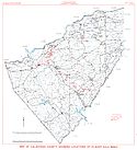
Main Author:
Department of Natural Resources, Division of Mines
Title/Description:
Map of Tulare County, California Showing Mines and Prospects
Publication Info:
Sacramento: Department of Natural Resources, Division of Mines, 1958; from Journal Vol. 54, No. 3, Plate 4
Viewing Options
Main Author:
Department of Natural Resources, Division of Mines
Title/Description:
Geologic Map of Contra Costa County Showing Mines, Quarries and Gas Wells
Publication Info:
Sacramento: Department of Natural Resources, Division of Mines, 1958; from Journal Vol. 54, No. 4, Plate 5
Viewing Options
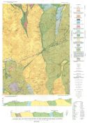
Main Author:
Department of Conservation, Division of Mines and Geology
Title/Description:
Generalized Geologic Map of Trinity County, California
Publication Info:
Sacramento: Department of Conservation: Division of Mines and Geology, 1960; from County Report 4, Plate 2
Viewing Options
Main Author:
U.S. Geological Survey
Title/Description:
Geologic Map and Sections of the Alvord Mountain Quadrangle, San Bernardino County, California
Publication Info:
Washington: Department of the Interior, U.S. Geological Survey, 1960; Bulletin 1089-A Plate 1
Viewing Options
Main Author:
U.S. Geological Survey
Title/Description:
Geologic Map and Sections of the Rogers Lake and Kramer Quadrangle, California
Publication Info:
Washington: Department of the Interior, U.S. Geological Survey, 1960; Bulletin 1089-B Plate 8
Viewing Options
Main Author:
California Division of Mines and Geology
Title/Description:
Map of Calaveras County Showing Locations of Lode Gold Mines and Prospects
Publication Info:
Sacramento: Department of Conservation: Division of Mines and Geology, 1962
Viewing Options
Main Author:
California Division of Mines and Geology
Title/Description:
Map of Calaveras County Showing Locations of Placer Gold Mines
Publication Info:
Sacramento: Department of Conservation: Division of Mines and Geology, 1962
Viewing Options
Main Author:
California Division of Mines and Geology
Title/Description:
Map of Calaveras County Showing Mines and Mineral Deposits, Except Gold
Publication Info:
Sacramento: Department of Conservation: Division of Mines and Geology, 1962
Viewing Options
Main Author:
U.S. Geological Survey
Title/Description:
Geologic Map and Sections of the Willow Springs and Rosamond Quadrangles, California
Publication Info:
Washington: Department of the Interior, U.S. Geological Survey, 1963; Bulletin 1089-C Plate 10
Viewing Options
Main Author:
U.S. Geological Survey
Title/Description:
Geologic Map of the Reliz Canyon Quadrangle, Monterey County, California
Publication Info:
Washington: Department of the Interior, U.S. Geological Survey, 1963; Bulletin 1041-Q Plate 1
Viewing Options
Main Author:
U.S. Geological Survey
Title/Description:
Geologic Map of the Thompson Canyon Quadrangle, Monterey County, California
Publication Info:
Washington: Department of the Interior, U.S. Geological Survey, 1963; Bulletin 1041-Q Plate 2
Viewing Options
Main Author:
U.S. Geological Survey
Title/Description:
Geologic Map of the San Lucas Quadrangle, Monterey County, California
Publication Info:
Washington: Department of the Interior, U.S. Geological Survey, 1963; Bulletin 1041-Q Plate 3
Viewing Options
Main Author:
U.S. Geological Survey
Title/Description:
Geologic Map and Sections of the Mount Pinchot Quadrangle, California
Publication Info:
Washington: Department of the Interior, U.S. Geological Survey, 1963; Bulletin 1130 Plate 1
Viewing Options
Main Author:
U.S. Geological Survey
Title/Description:
Geologic Map of the Espanosa Canyon Quadrangle, Monterey County, California
Publication Info:
Washington: Department of the Interior, U.S. Geological Survey, 1964; Bulletin 1061-H Plate 2
Viewing Options
Main Author:
U.S. Geological Survey
Title/Description:
Geologic Map of the Cosio Knob Quadrangle, Monterey County, California
Publication Info:
Washington: Department of the Interior, U.S. Geological Survey, 1964; Bulletin 1061-H Plate 1
Viewing Options
Main Author:
U.S. Geological Survey
Title/Description:
Geologic Map and Section of the French Gulch Quadrangle, Shasta and Trinity Counties, California
Publication Info:
Washington: Department of the Interior, U.S. Geological Survey, 1964; Bulletin 1041-J Plate 1

