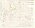
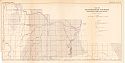
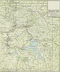
Viewing Options
Main Author:
U.S. Department of the Interior, U.S. Geological Survey
Title/Description:
Map Showing Petroleum Withdrawals Outstanding on January 15, 1916 in the State of Wyoming
Publication Info:
Washington: Department of the Interior, U.S. Geological Survey, 1916
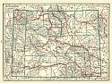
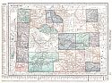
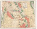
Viewing Options
Main Author:
Office of State Geologist
Title/Description:
Topographic Map of Wyoming
Publication Info:
Cheyenne: Office of State Geologist, 1916
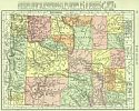
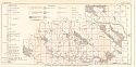
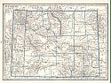
Viewing Options
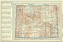
Main Author:
Rand McNally and Company
Title/Description:
Wyoming
Publication Info:
Chicago: Rand McNally and Co., 1916; from The Ideal Atlas of the World
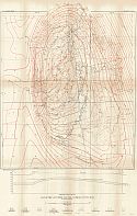
Viewing Options
Main Author:
U.S. Geological Survey
Title/Description:
Geologic Map of the North Laramie Mountains and Adjacent Region, Wyoming
Publication Info:
Washington: Department of the Interior, U.S. Geological Survey, 1916; Bulletin 626 Plate IV
Viewing Options
Main Author:
U.S. Geological Survey
Title/Description:
Map of Southwestern Wyoming showing area of Green River Formation
Publication Info:
Washington: Department of the Interior, U.S. Geological Survey, 1916; Bulletin 641 Plate 19
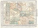
Viewing Options
Main Author:
Hammond, C.S.
Title/Description:
Wyoming
Publication Info:
New York: C.S. Hammond and Company, 1917; from The Universal Atlas of the World
Viewing Options
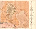
Main Author:
U.S. Geological Survey
Title/Description:
Map Showing Anticlines in Natrona and Fremont Counties in Central Wyoming
Publication Info:
Washington: Department of the Interior, U.S. Geological Survey, 1917; Bulletin 641 Plate 23
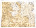
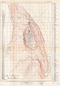
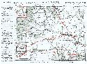
Viewing Options
Main Author:
U.S. Geological Survey
Title/Description:
Map of Salt Creek Oil Pool, Natrona County, Wyoming
Publication Info:
Washington: Department of the Interior, U.S. Geological Survey, 1918; Bulletin 670 Plate II
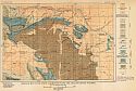
Viewing Options
Main Author:
U.S. Geological Survey
Title/Description:
Map of Salt Creek Oil Field including the Shannon Pool and Teapot Dome, Natrona County, Wyoming
Publication Info:
Washington: Department of the Interior, U.S. Geological Survey, 1918; Bulletin 670 Plate I
Viewing Options
Main Author:
C.S. Hammond and Company
Title/Description:
Wyoming
Publication Info:
New York: C.S. Hammond and Company, 1918; from Hammonds Pictorial Atlas of the World
Viewing Options
Main Author:
U.S. Geological Survey
Title/Description:
Geologic Map of Rock Springs Area, Sweetwater County, Wyoming
Publication Info:
Washington: Department of the Interior, U.S. Geological Survey, 1919; Bulletin 702 Plate I
Viewing Options
Main Author:
Reynolds, Francis J.
Title/Description:
Wyoming
Publication Info:
New York: P.F. Collier and Son Company, 1920; from The New World Atlas and Gazetteer
Viewing Options
Main Author:
Cram, George F.
Title/Description:
Yellowstone National Park
Publication Info:
Chicago: James R. Gray and Company, 1920; from Cram's Unrivaled Atlas of the World
Viewing Options
Title/Description:
Areal Geology of Wyoming
Publication Info:
Cheyenne: G.B. Morgan and C.S. Hill, 1920
Viewing Options
Main Author:
C.S. Hammond and Company
Title/Description:
Wyoming
Publication Info:
New York: C.S. Hammond and Company, 1920; from The New Reference Atlas of the World
Original Source:
Courtesy of Shawn Carter
Viewing Options
Main Author:
Leslie-Judge Company
Title/Description:
Wyoming
Publication Info:
New York: Leslie-Judge Company1920; from Leslie's New World Atlas
Viewing Options
Main Author:
Wyoming Department of Agriculture
Title/Description:
Wyoming
Publication Info:
[Cheyenne] c. 1920
Original Source:
Murray Hudson

