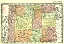
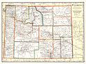
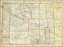
Viewing Options
Main Author:
Rand McNally and Company
Title/Description:
Wyoming
Publication Info:
Chicago: Rand McNally and Co., 1911; from the Commercial Atlas of America
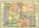
Viewing Options
Main Author:
Hammond, C.S.
Title/Description:
Wyoming
Publication Info:
New York: C.S. Hammond and Company, 1911; from Hammond's Modern Atlas of the World
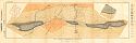
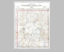
Viewing Options
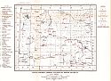
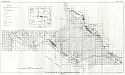
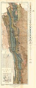
Main Author:
U.S. Geological Survey
Title/Description:
Map Lander Oil Field, Wyoming, with Section
Publication Info:
Washington: Department of the Interior, U.S. Geological Survey, 1911; Bulletin 452 Plate I
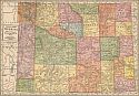
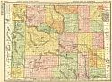
Viewing Options
Main Author:
Geographical Publishing Company
Title/Description:
Wyoming
Publication Info:
Chicago: The Geographical Publishing Company, 1911
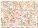
Viewing Options
Main Author:
Cram, George F.
Title/Description:
Wyoming
Publication Info:
Chicago: George F. Cram, 1911; from Cram's Unrivaled Atlas of the World
Viewing Options
Main Author:
U.S. Geological Survey
Title/Description:
Yellowstone National Park
Publication Info:
Washington: Department of the Interior, U.S. Geological Survey, 1911
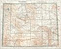
Viewing Options
Main Author:
Rand McNally and Company
Title/Description:
Wyoming
Publication Info:
Chicago: Rand McNally and Co., 1912; from The Library Atlas of the World
Viewing Options
Main Author:
Rand McNally and Company
Title/Description:
Wyoming
Publication Info:
Chicago: Rand McNally and Company, 1912; from The Rand McNally Imperial Atlas of the World
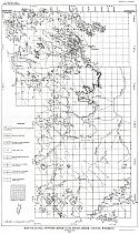
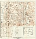
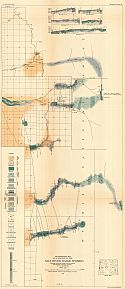
Viewing Options
Main Author:
U.S. Geological Survey
Title/Description:
Map of Wyoming, Showing Location of Mining Districts
Publication Info:
Washington: Department of the Interior, U.S. Geological Survey, 1912; from Bulletin 507 Plate XVI
Viewing Options
Main Author:
U.S. Geological Survey
Title/Description:
Map of Little Powder River Coal Field, Crook County, Wyoming
Publication Info:
Washington: Department of the Interior, U.S. Geological Survey, 1912; Bulletin 471 Plate XXXIV
Viewing Options
Main Author:
U.S. Geological Survey
Title/Description:
Map of the Lost Spring Coal Field, Wyoming
Publication Info:
Washington: Department of the Interior, U.S. Geological Survey, 1912; Bulletin 471 Plate XLV
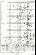
Viewing Options
Main Author:
U.S. Geological Survey
Title/Description:
Geologic Map of the Wind River Region, Wyoming
Publication Info:
Washington: Department of the Interior, U.S. Geological Survey, 1912; Bulletin 471 Plate XLIX
Viewing Options
Main Author:
U.S. Geological Survey
Title/Description:
Map of Powder River Coal Field, Wind River Region, Wyoming
Publication Info:
Washington: Department of the Interior, U.S. Geological Survey, 1912; Bulletin 471 Plate LVI
Viewing Options
Main Author:
Cram, George F.
Title/Description:
Wyoming
Publication Info:
Chicago: George F. Cram, 1913; from Cram's Unrivaled Atlas of the World
Viewing Options
Main Author:
U.S. Geological Survey
Title/Description:
Map of the Barber Coal Field, Johnson County, Wyoming
Publication Info:
Washington: Department of the Interior, U.S. Geological Survey, 1913; Bulletin 531 Plate XIX
Viewing Options
Main Author:
Reynolds, Francis J.
Title/Description:
Wyoming
Publication Info:
New York: P.F. Collier and Son, 1914; from The New Encyclopededic Atlas and Gazatteer of the World
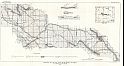
Viewing Options
Main Author:
U.S. Geological Survey
Title/Description:
Topographic and Geologic Map of a Portion of Lincoln County, Wyoming
Publication Info:
Washington: Department of the Interior, U.S. Geological Survey, 1914; Bulletin 543 Plate I
Viewing Options
Main Author:
C.S Hammond and Company
Title/Description:
Wyoming
Publication Info:
New York: C.S. Hammond and Company, 1914; from Hammond's Commercial and Library Atlas of the World
Viewing Options
Main Author:
U.S. Geological Survey
Title/Description:
Reconnaissance Map of a Portion of the Salt River Range, Wyoming
Publication Info:
Washington: Department of the Interior, U.S. Geological Survey, 1915; Bulletin 620 Plate XII

