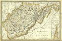
Viewing Options
Main Author:
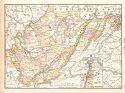
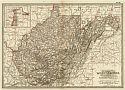
Rand McNally and Company
Title/Description:
New Map of West Virginia
Publication Info:
Chicago: Rand McNally and Company, 1891; from The Enlarged Business Atlas and Shippers Guide
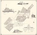
Viewing Options
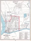
Main Author:
Taylor, D.F.
Title/Description:
Map of the Property of the Charlestown Mining, Manufacturing and Improvement Co.
Publication Info:
Washington: D.J. Howell, 1891
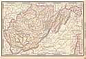
Viewing Options
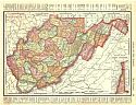
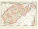
Main Author:
Rand McNally and Company
Title/Description:
West Virginia
Publication Info:
Chicago: Rand McNally & Co., 1893; from Rand McNally & Co.'s Universal Atlas of the World
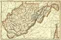
Viewing Options
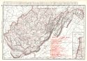
Main Author:
Rand McNally and Company
Title/Description:
West Virignia
Publication Info:
Chicago: Rand McNally and Co., 1893; from Rand McNally and Company's Enlarged Business Atlas and Shippers Guide
Viewing Options
Main Author:
Rand McNally and Company
Title/Description:
West Virginia
Publication Info:
Chicago: Rand McNally and Company, 1894; from Rand McNally and Company's Encyclopedia and Gazetteer
Viewing Options
Main Author:
Rand McNally and Company
Title/Description:
West Virginia
Publication Info:
Chicago: Rand McNally & Co., 1895; from Rand McNally's New General Atlas of the World
Viewing Options
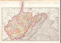
Main Author:
Rand McNally and Company
Title/Description:
West Virginia
Publication Info:
Chicago: Rand McNally and Company, 1896; from Enlarged Business Atlas
Viewing Options
Main Author:
Rand McNally and Company
Title/Description:
West Virginia
Publication Info:
Chicago: Rand McNally and Company,1896; from Indexed Atlas of the World
Viewing Options
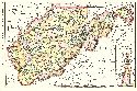
Main Author:
Cram, George F.
Title/Description:
Map of Parkersburg, West Virginia and Vicinity
Publication Info:
Chicago: George F. Cram, 1898; from Cram's Universal Atlas, Geographical, Astronomical and Historical
Viewing Options
Main Author:
Rand McNally and Company
Title/Description:
Rand McNally and Company's New Map of West Virginia
Publication Info:
Chicago: Rand McNally & Co., 1898; from Rand McNally and Co.'s Atlas of the World
Viewing Options
Main Author:
Rand McNally and Company
Title/Description:
West Virginia
Publication Info:
Chicago: Rand McNally and Company, c.1898
Viewing Options
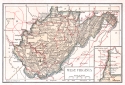
Main Author:
Morris, Russell L.
Title/Description:
Map of West Virginia
Publication Info:
West Virginia Geological and Ecomonic Survey, 1899
Viewing Options
Main Author:
Smith, Benjamin E.
Title/Description:
West Virginia
Publication Info:
New York: The Century Company, 1899; from The Century Atlas of the World
Viewing Options
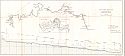
Main Author:
U.S. Army Corps of Engineers
Title/Description:
West Fork River, W. VA.
Publication Info:
Washington: U.S. House of Representatives, 56th Congress, 1st Session, Doc. No. 88
Viewing Options
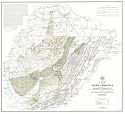
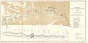
Main Author:
U.S. Army Corps of Engineers
Title/Description:
Geological Map, West Fork River Valley, W. Va.
Publication Info:
Washington: U.S. House of Representatives, 56th Congress, 1st Session, Doc. No. 88, 1899
Viewing Options
Main Author:
The Bradstreet Company
Title/Description:
West Virginia
Publication Info:
New York: The Bradstreet Company, 1899; from Bradstreet's Pocket Atlas of the United States

