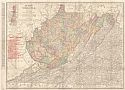
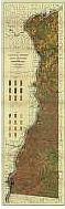
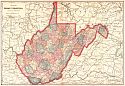
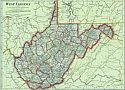
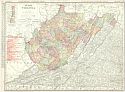
Viewing Options
Main Author:
Rand McNally and Company
Title/Description:
West Virginia
Publication Info:
Chicago: Rand McNally & Co., 1906
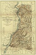
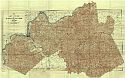
Viewing Options
Main Author:
West Virginia Geological Survey
Title/Description:
Map of Brooke County Showing the Outcrops of Geologic Formations
Publication Info:
Morgantown: West Virginia Geological Survey, 1906
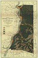
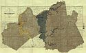
Viewing Options
Main Author:
West Virginia Geological Survey
Title/Description:
Map of Brooke County Showing the Geologic Formations
Publication Info:
Morgantown: West Virginia Geological Survey, 1906
Viewing Options
Main Author:
West Virginia Geological Survey
Title/Description:
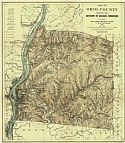
Map of Ohio County Showing Geologic Formations
Publication Info:
Morgantown: West Virginia Geological Survey, 1906
Viewing Options
Main Author:
West Virginia Geological Survey
Title/Description:
Map of Ohio County Showing the Outcrops of Geologic Formations
Publication Info:
Morgantown: West Virginia Geological Survey, 1906
Viewing Options
Main Author:
West Virginia Geological Survey
Title/Description:
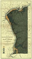
Map of Hancock County Showing the Geologic Formations
Publication Info:
Morgantown: West Virginia Geological Survey, 1906
Viewing Options
Main Author:
West Virginia Geological Survey
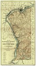
Title/Description:
Map of Hancock County Showing The Outcrops Of Geologic Formations
Publication Info:
Morgantown: West Virginia Geological Survey, 1906
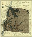
Viewing Options
Main Author:
West Virginia Geological Survey
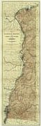
Title/Description:
Map of Hancock, Brooke and Ohio Counties Showing Topography
Publication Info:
Morgantown: West Virginia Geological Survey, 1906
Viewing Options
Main Author:
West Virginia Geological Survey
Title/Description:
Map of Hancock, Brooke and Ohio Counties Showing Agricultural Soils
Publication Info:
Morgantown: West Virginia Geological Survey, 1906
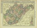
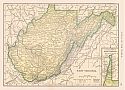
Viewing Options
Main Author:
Hammond, C.S.
Title/Description:
West Virginia
Publication Info:
New York: C.S. Hammond and Company, 1906; from The Pictorial Atlas of the World
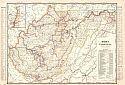
Viewing Options
Main Author:
Cram, George F.
Title/Description:
West Virginia
Publication Info:
Chicago: George F. Cram for A. A. Grant, Toronto, Ont., 1906; from Grant's Bankers and Brokers Railroad System Atlas
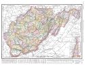
Viewing Options
Main Author:
Rand McNally and Company
Title/Description:
West Virginia
Publication Info:
Chicago: Rand McNally and Company, 1906; from The World and its Peoples
Viewing Options
Main Author:
Cram, George F.
Title/Description:
West Virginia
Publication Info:
Chicago: George F. Cram, 1907; from Cram's Ideal Reference Atlas of the World
Viewing Options
Main Author:
Hammond, C.S.
Title/Description:
West Virginia
Publication Info:
New York: C.S. Hammond & Co. 1908; from Hammond's Handy Atlas of the World
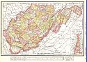
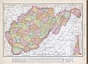
Viewing Options
Main Author:
Rand McNally and Company
Title/Description:
West Virginia
Publication Info:
Chicago: Rand McNally and Company, 1908; from The New Ideal State and County Survey and Atlas
Viewing Options
Main Author:
West Virginia Geological Survey
Title/Description:
Map of Marshall, Wetzel and Tyler Counties Showing Topography
Publication Info:
Morgantown: West Virginia Geological Survey, 1909
Viewing Options
Main Author:
West Virginia Geological Survey
Title/Description:
Map of Wood, Ritchie and Pleasants Counties Showing Topography
Publication Info:
Morgantown: West Virginia Geological Survey, 1909
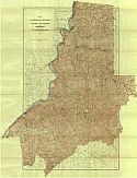
Viewing Options
Main Author:
West Virginia Geological Survey
Title/Description:
Map of Wood, Ritchie And Pleasants Counties Showing General And Economic Geology
Publication Info:
Morgantown: West Virginia Geological Survey, 1909
Viewing Options
Main Author:
Cram, George F.
Title/Description:
West Virginia
Publication Info:
Chicago: George F. Cram, c.1909; from The Heart of our Country
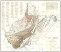
Viewing Options
Main Author:
West Virginia Geological Survey
Title/Description:
Map of West Virginia Showing Coal, Oil, Gas And Limestone Areas
Publication Info:
Morgantown: West Virginia Geological Survey, 1910
Viewing Options
Main Author:
Rand McNally and Company
Title/Description:
West Virginia
Publication Info:
Chicago: Rand McNally and Company, 1910; from The Enlarged Business Atlas and Shippers Guide
Viewing Options
Main Author:
Rand McNally and Company
Title/Description:
West Virginia
Publication Info:
Chicago: Rand McNally and Company 1910; from New Ideal State and County Survey

