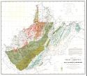
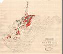
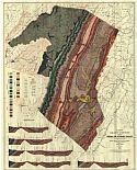
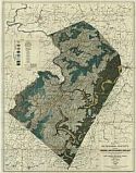
Viewing Options
Title/Description:
Map of West Virginia Showing Coal, Oil, Gas, Iron Ore and Limestone Areas
Publication Info:
Morgantown: West Virginia Geological Survey, 1921
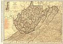
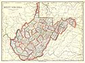
Viewing Options
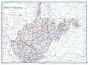
Main Author:
Rand McNally and Company
Title/Description:
West Virginia
Publication Info:
Chicago: Rand McNally and Company, 1921; from The Commercial Atlas of America
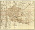
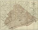
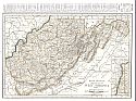
Viewing Options
Main Author:
West Virginia Geological Survey
Title/Description:
Map I of Tucker County Showing Topography
Publication Info:
Morgantown: West Virginia Geological Survey, 1921
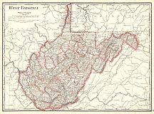
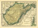
Viewing Options
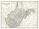
Main Author:
Cram, George F.
Title/Description:
West Virginia
Publication Info:
Chicago: George F. Cram Company, 1921; from Cram's Unrivaled Atlas of the World
Viewing Options
Main Author:
National Map Company
Title/Description:
West Virginia
Publication Info:
Indianapolis: National Map Company, 1921; from Auto Trails and Commercial Survey of the United States
Viewing Options
Main Author:
National Map Company
Title/Description:
West Virginia
Publication Info:
Indianapolis: National Map Company, 1921; from Auto Trails and Commercial Survey of the United States
Viewing Options
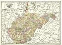
Main Author:
The Geographical Publishing Co.
Title/Description:
West Virginia
Publication Info:
Chicago: The Geographical Publishing Co., 1922; from The New International Atlas of the World
Viewing Options
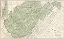
Main Author:
C.S. Hammond
Title/Description:
West Virginia
Publication Info:
New York: C.S. Hammond and Company, 1922; from The New World Looseleaf Atlas
Viewing Options
Main Author:
U.S. Geological Survey
Title/Description:
Oil and Gas Fields of the State of West Virginia
Publication Info:
Washington: Department of the Interior, U.S. Geological Survey, 1922
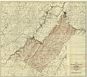
Viewing Options
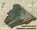
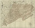
Main Author:
West Virginia Geological Survey
Title/Description:
Map I Of Mineral County Showing Topography
Publication Info:
Morgantown: West Virginia Geological Survey, 1923
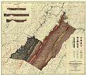
Viewing Options
Main Author:
West Virginia Geological Survey
Title/Description:
Map II of Mineral County Showing General and Economic Geology
Publication Info:
Morgantown: West Virginia Geological Survey, 1923
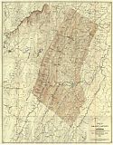
Viewing Options
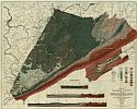
Main Author:
West Virginia Geological Survey
Title/Description:
Map III of Grant County Showing Topography
Publication Info:
Morgantown: West Virginia Geological Survey, 1923
Viewing Options
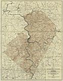
Main Author:
West Virginia Geological Survey
Title/Description:
Map IV of Grant County Showing General and Economic Geology
Publication Info:
Morgantown: West Virginia Geological Survey, 1923
Viewing Options
Main Author:
Cram, George F.
Title/Description:
West Virginia
Publication Info:
Chicago: George F. Cram Company, 1923; from Cram's Unrivaled Atlas of the World
Viewing Options
Main Author:
Funk and Wagnalls Company
Title/Description:
West Virginia
Publication Info:
New York: Funk and Wagnalls Company, 1923; from Atlas of the World and Gazetteer
Viewing Options
Main Author:
West Virginia Geological Survey
Title/Description:
Map I of Mercer County Showing Topography
Publication Info:
Morgantown: West Virginia Geological Survey, 1925
Viewing Options
Main Author:
West Virginia Geological Survey
Title/Description:
Map II of Mercer County Showing General and Economic Geology
Publication Info:
Morgantown: West Virginia Geological Survey, 1925
Viewing Options
Main Author:
West Virginia Geological Survey
Title/Description:
Map III of Monroe County Showing Topography
Publication Info:
Morgantown: West Virginia Geological Survey, 1925
Viewing Options
Main Author:
West Virginia Geological Survey
Title/Description:
Map IV of Monroe County Showing General and Economic Geology
Publication Info:
Morgantown: West Virginia Geological Survey, 1925
Viewing Options
Main Author:
West Virginia Geological Survey
Title/Description:
Map V of Summers County Showing Topography
Publication Info:
Morgantown: West Virginia Geological Survey, 1925
Viewing Options
Main Author:
West Virginia Geological Survey
Title/Description:
Map VI of Summers County Showing General and Economic Geology
Publication Info:
Morgantown: West Virginia Geological Survey, 1925
Viewing Options
Main Author:
Rand McNally and Company
Title/Description:
West Virginia
Publication Info:
Chicago: Rand McNally and Company, 1925; from Premier Atlas of the World

