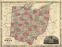
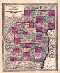
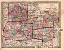
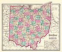
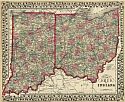
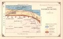
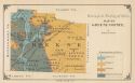
Viewing Options
Main Author:
Johnson, A.J.
Publication Info:
New York: Johnson and Ward, 1866; from Johnson's New Illustrated Family Atlas
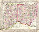
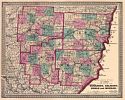
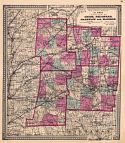
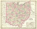
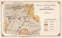
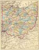
Viewing Options
Main Author:
Gamble, William H.
Title/Description:
County Map of Ohio and Indiana
Publication Info:
Philadelphia: S.A. Mitchell, 1867
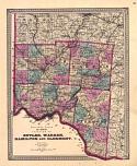
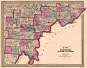
Viewing Options
Main Author:
Walling, Henry F.
Title/Description:
Walling's Atlas of Ohio Counties of Butler, Warren, Hamilton and Clermont
Publication Info:
New York: H.S. Stebbins, [1868]
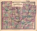
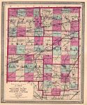
Viewing Options
Main Author:
Walling, Henry F.
Title/Description:
Walling's Atlas of Ohio Counties of Champaign, Darke, Greene, Miami, Montgomery, Clarke, and Preble
Publication Info:
New York: H.S. Stebbins, [1868]
Viewing Options
Main Author:
Walling, Henry F.
Title/Description:
Walling's Atlas of Ohio Counties of Columbia, Jefferson, Carroll and Harrison
Publication Info:
New York: H.S. Stebbins, [1868]
Viewing Options
Main Author:
Walling, Henry F.
Title/Description:
Walling Atlas of Ohio Counties Guernsey, Belmont, Noble and Monroe
Publication Info:
New York: H.S. Stebbins, [1868]
Viewing Options
Main Author:
Walling, Henry F.
Title/Description:
Walling Atlas of Ohio Counties of Hardin, Logan, Auglaize, Shelby, Allen, Van Wert and Mercer
Publication Info:
New York: H.S. Stebbins, [1868]
Viewing Options
Main Author:
Walling, Henry F.
Title/Description:
Walling Atlas of Ohio Counties of Jackson, Gallia, Lawrence, Scioto and Pike
Publication Info:
New York: H.S. Stebbins, [1868]
Viewing Options
Main Author:
Walling, Henry F.
Title/Description:
Walling Atlas of Ohio Counties of Pickaway, Hocking, Ross and Vinton
Publication Info:
New York: H.S. Stebbins, [1868]
Viewing Options
Main Author:
Walling, Henry F.
Title/Description:
Walling Atlas of Ohio Counties of Union, Delaware, Franklin and Madison
Publication Info:
New York: H.S. Stebbins, [1868]
Viewing Options
Main Author:
Walling, Henry F.
Title/Description:
Walling Atlas of Ohio Counties of Washington, Athens and Meigs
Publication Info:
New York: H.S. Stebbins, [1868]
Viewing Options
Main Author:
Walling, Henry F.
Title/Description:
Walling Atlas of Ohio Counties of Williams, Fulton, Defiance, Henry, Paulding and Putnam
Publication Info:
New York: H.S. Stebbins, [1868]
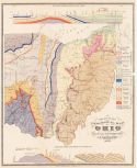
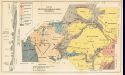
Viewing Options
Main Author:
Newberry, J.S.
Title/Description:
Preliminary Geological Map of Ohio
Publication Info:
Columbus: Geological Survey of Ohio, 1871
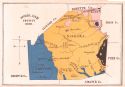
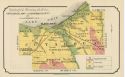
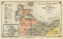
Viewing Options
Main Author:
Orton, Edward
Title/Description:
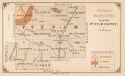
Highland County, Ohio
Publication Info:
Columbus: Ohio Geological Survey, 1871; Report of Progress in 1870
Viewing Options
Main Author:
Asher & Adams
Title/Description:
Asher and Adams' Ohio and Indiana
Publication Info:
New York: Asher & Adams, c1872
Viewing Options
Main Author:
Gamble, William H.
Title/Description:
County Map of Ohio and Indiana
Publication Info:
Philadelphia: S.A. Mitchell, 1872
Viewing Options
Main Author:
Gray, Ormando W.
Title/Description:
Gray's Atlas Map of Ohio
Publication Info:
Philadelphia: O.W. Gray & Son, 1873
Viewing Options
Main Author:
Colton, G.W. & C.B. Colton
Title/Description:
Colton's Ohio
Publication Info:
New York: G.W. & C.B. Colton, c.1873
Viewing Options
Main Author:
Newberry, J.S.
Title/Description:
Geological Map of Cuyahoga County
Publication Info:
Columbus: Geological Survey of Ohio, 1873; Report of the Geological Survey of Ohio, Volume 1

Viewing Options
Main Author:
Newberry, J.S.
Title/Description:
Geological Map of Summit County
Publication Info:
Columbus: Geological Survey of Ohio, 1873; Report of the Geological Survey of Ohio, Volume 1
Viewing Options
Main Author:
Orton, Edward
Title/Description:
Map Showing Lines of Junction of Cincinnati Group and Clinton Limestone, or a Lower and Upper Silurian, in South Western Ohio
Publication Info:
Columbus: Geological Survey of Ohio, 1873; Report of the Geological Survey of Ohio, Volume 1
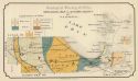
Viewing Options
Main Author:
Orton, Edward
Title/Description:
Map of Hamilton County Representing the Highland and Lowland, or the Bedded Rocks and Eroded River Valleys
Publication Info:
Columbus: Geological Survey of Ohio, 1873; Report of the Geological Survey of Ohio, Volume 1
Viewing Options
Main Author:
Orton, Edward
Title/Description:
Geological Map of Clarke County
Publication Info:
Columbus: Geological Survey of Ohio, 1873; Report of the Geological Survey of Ohio, Volume 1
Viewing Options
Title/Description:
Geological Map of Ashtabula, Lake, Geouga and Trumbull Counties
Publication Info:
Columbus: Geological Survey of Ohio, 1873; Report of the Geological Survey of Ohio, Volume 1
Viewing Options
Main Author:
Gilbert, G.K.
Title/Description:
Map of Lucus County Colored to show Geological Structure
Publication Info:
Columbus: Geological Survey of Ohio, 1873; Report of the Geological Survey of Ohio, Volume 1
Viewing Options
Main Author:
Winchell, N.H.
Title/Description:
Geological Map of Sandusky County
Publication Info:
Columbus: Geological Survey of Ohio, 1873; report of the Geological Survey of Ohio, Volume !

Viewing Options
Main Author:
Winchell, N.H.
Title/Description:
Geological Map of Seneca County
Publication Info:
Columbus: Geological Survey of Ohio, 1873; Report of the Geological Survey of Ohio, Volume 1
Viewing Options
Main Author:
Winchell, N.H.
Title/Description:
Geological Map of Wyandot County
Publication Info:
Columbus: Geological Survey of Ohio, 1873; Report of the Geological Survey of Ohio, Volume 1
Viewing Options
Main Author:
Winchell, N.H.
Title/Description:
Geological Map of Marion County
Publication Info:
Columbus: Geological Survey of Ohio, 1873; Report of the Geological Survey of Ohio, Volume 1
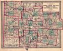
Viewing Options
Main Author:
Mitchell, S. Augustus
Title/Description:
County Map of Ohio and Indiana
Publication Info:
Philadelphia: S. A. Mitchell, 1873; from Mitchell's New General Atlas
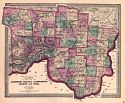
Viewing Options
Main Author:
Mitchell, S. Augustus
Title/Description:
County Map of Ohio and Indiana
Publication Info:
Philadelphia: S. Augustus Mitchell, 1874; from Mitchell's New General Atlas
Viewing Options
Main Author:
Winchell, N.H.
Title/Description:
Map of Erie County and the Islands
Publication Info:
Columbus: Geological Survey of Ohio, 1874; Report of the Geological Survey of Ohio, Volume 1I
Viewing Options
Main Author:
Winchell, N.H.
Title/Description:
Geological map of Ottawa County
Publication Info:
Columbus: Geological Survey of Ohio, 1874; Report of the Geological Survey of Ohio, Volume 1I
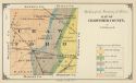
Viewing Options
Main Author:
Winchell, N.H.
Title/Description:
Map of Crawford County
Publication Info:
Columbus: Geological Survey of Ohio, 1874; Report of the Geological Survey of Ohio, Volume 1I
Viewing Options
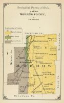
Main Author:
Winchell, N.H.
Title/Description:
Map of Morrow County
Publication Info:
Columbus: Geological Survey of Ohio, 1874; Report of the Geological Survey of Ohio, Volume 1I
Viewing Options
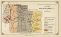
Main Author:
Winchell, N.H.
Title/Description:
Map of Delaware County
Publication Info:
Columbus: Geological Survey of Ohio, 1874; Report of the Geological Survey of Ohio, Volume 1I
Viewing Options
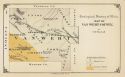
Main Author:
Winchell, N.H.
Title/Description:
Map of Van Wert County
Publication Info:
Columbus: Geological Survey of Ohio, 1874; Report of the Geological Survey of Ohio, Volume 1I
Viewing Options
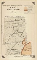
Main Author:
Winchell, N.H.
Title/Description:
Map of Union County
Publication Info:
Columbus: Geological Survey of Ohio, 1874; Report of the Geological Survey of Ohio, Volume 1I
Viewing Options
Main Author:
Winchell, N.H.
Title/Description:
Map of Paulding County
Publication Info:
Columbus: Geological Survey of Ohio, 1874; Report of the Geological Survey of Ohio, Volume 1I
Viewing Options
Main Author:
Winchell, N.H.
Title/Description:
Map of Hardin County
Publication Info:
Columbus: Geological Survey of Ohio, 1874; Report of the Geological Survey of Ohio, Volume 1I
Viewing Options
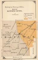
Main Author:
Winchell, N.H.
Title/Description:
Map of Hancock County
Publication Info:
Columbus: Geological Survey of Ohio, 1874; Report of the Geological Survey of Ohio, Volume 1I
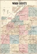
Viewing Options
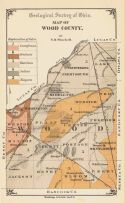
Main Author:
Winchell, N.H.
Title/Description:
Map of Wood County
Publication Info:
Columbus: Geological Survey of Ohio, 1874; Report of the Geological Survey of Ohio, Volume 1I
Viewing Options
Main Author:
Winchell, N.H.
Title/Description:
Map of Putnam County
Publication Info:
Columbus: Geological Survey of Ohio, 1874; Report of the Geological Survey of Ohio, Volume 1I
Viewing Options
Main Author:
Winchell, N.H.
Title/Description:
Map of Henry County
Publication Info:
Columbus: Geological Survey of Ohio, 1874; Report of the Geological Survey of Ohio, Volume 1I
Viewing Options
Main Author:
Winchell, N.H.
Title/Description:
Map of Defiance County
Publication Info:
Columbus: Geological Survey of Ohio, 1874; Report of the Geological Survey of Ohio, Volume 1I
Viewing Options
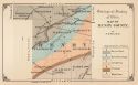
Main Author:
Geological Survey of Ohio
Title/Description:
Map of Highland, Ross and Pike Counties
Publication Info:
Columbus: Geological Survey of Ohio, 1874; Report of the Geological Survey of Ohio, Volume 1I
Viewing Options
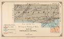
Main Author:
Orton, Edward
Title/Description:
Map of Greene County
Publication Info:
Columbus: Geological Survey of Ohio, 1874; Report of the Geological Survey of Ohio, Volume 1I
Viewing Options
Main Author:
Hardesty, H.H.
Publication Info:
Chicago: H.H. Hardesty & Co., 1875
Viewing Options
Main Author:
Jones, Charles H. and Theodore F. Hamilton
Title/Description:
Map of Wood County, Ohio
Publication Info:
Chicago: H.H. Hardesty, 1875; from Historical Atlas of the World Illustrated
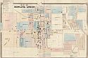
Viewing Options
Main Author:
Jones, Charles H. and Theodore F. Hamilton
Title/Description:
Map of Bowling Green [Wood County]
Publication Info:
Chicago: H.H. Hardesty, 1875; from Historical Atlas of the World Illustrated
Viewing Options
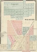
Main Author:
Jones, Charles H. and Theodore F. Hamilton
Title/Description:
Eagleville, Weston [Cook County, Ohio]
Publication Info:
Chicago: H.H. Hardesty, 1875; from Historical Atlas of the World Illustrated
Viewing Options
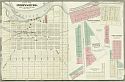
Main Author:
Jones, Charles H. and Theodore F. Hamilton
Title/Description:
Map of Perryburg [Cook County, Ohio]
Publication Info:
Chicago: H.H. Hardesty, 1875; from Historical Atlas of the World Illustrated
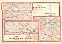
Viewing Options
Main Author:
Hardesty, H.H.
Title/Description:
Map of Fulton Co. Ohio, Map of Henry Co. Ohio, Map of Defiance Co. Ohio
Publication Info:
Chicago: H.H. Hardesty and Company, 1875; from Historical Atlas of the World Illustrated
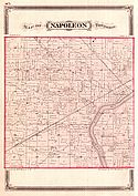
Viewing Options
Main Author:
Hardesty, H.H.
Title/Description:
Map of Napolean Township (Henry County, Ohio)
Publication Info:
Chicago: H.H. Hardesty and Company, 1875; from Historical Atlas of the World Illustrated
Viewing Options
Main Author:
Hardesty, H.H.
Title/Description:
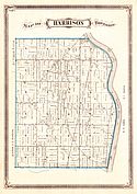
Map of Harrison Township (Henry County, Ohio)
Publication Info:
Chicago: H.H. Hardesty and Company, 1875; from Historical Atlas of the World Illustrated
Viewing Options
Main Author:
Hardesty, H.H.
Title/Description:
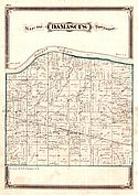
Map of Damascus Township (Henry County, Ohio)
Publication Info:
Chicago: H.H. Hardesty and Company, 1875; from Historical Atlas of the World Illustrated
Viewing Options
Main Author:
Hardesty, H.H.
Title/Description:
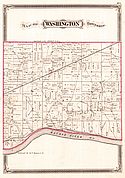
Map of Washington Township (Henry County, Ohio)
Publication Info:
Chicago: H.H. Hardesty and Company, 1875; from Historical Atlas of the World Illustrated
Viewing Options
Main Author:
Hardesty, H.H.
Title/Description:
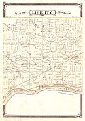
Map of Liberty Township (Henry County, Ohio)
Publication Info:
Chicago: H.H. Hardesty and Company, 1875; from Historical Atlas of the World Illustrated
Viewing Options
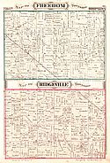
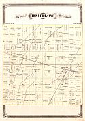
Main Author:
Hardesty, H.H.
Title/Description:
Map of Freedom Township, Map of Ridgeville Township (Henry County, Ohio)
Publication Info:
Chicago: H.H. Hardesty and Company, 1875; from Historical Atlas of the World Illustrated
Viewing Options
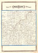
Main Author:
Hardesty, H.H.
Title/Description:
Map of Pleasant Township (Henry County, Ohio)
Publication Info:
Chicago: H.H. Hardesty and Company, 1875; from Historical Atlas of the World Illustrated
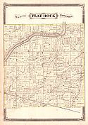
Viewing Options
Main Author:
Hardesty, H.H.
Title/Description:
Map of Flat Rock Township (Henry County, Ohio)
Publication Info:
Chicago: H.H. Hardesty and Company, 1875; from Historical Atlas of the World Illustrated
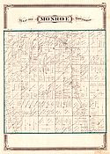
Viewing Options
Main Author:
Hardesty, H.H.
Title/Description:
Map of Monroe Township (Henry County, Ohio)
Publication Info:
Chicago: H.H. Hardesty and Company, 1875; from Historical Atlas of the World Illustrated
Viewing Options
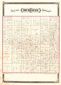
Main Author:
Hardesty, H.H.
Title/Description:
Map of Richfield Township (Henry County, Ohio)
Publication Info:
Chicago: H.H. Hardesty and Company, 1875; from Historical Atlas of the World Illustrated
Viewing Options
Main Author:
Hardesty, H.H.
Title/Description:
Map of Bartlow Township (Henry County, Ohio)
Publication Info:
Chicago: H.H. Hardesty and Company, 1875; from Historical Atlas of the World Illustrated
Viewing Options
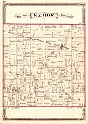
Main Author:
Hardesty, H.H.
Title/Description:
Map of Marion Township (Henry County, Ohio)
Publication Info:
Chicago: H.H. Hardesty and Company, 1875; from Historical Atlas of the World Illustrated

