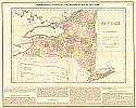
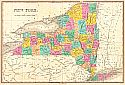
Viewing Options
Main Author:
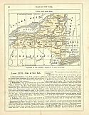
Lucas, Fielding
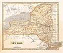
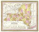
Title/Description:
Geographical, Statistical, and Historical Map of New York
Publication Info:
Philadelphia: Carey & Lea, 1826
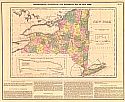
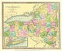
Viewing Options
Main Author:
Carey and Lea
Title/Description:
Geographical, Statistical, and Historical Map of New York
Publication Info:
Philadelphia: Carey & Lea, 1827
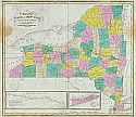
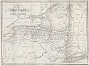
Viewing Options
Main Author:
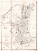
Young, James H.
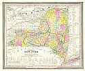
Title/Description:
Map of the State of New York
Publication Info:
New York: Joseph C. Hart, 1827; Drawn & Engraved to Illustrate Hart's Geographical Exercises
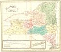
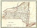
Viewing Options
Main Author:
Hart, Joseph C.
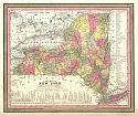
Title/Description:
Map of the State of New York
Publication Info:
New York: R. Lockwood, 1828 from A Modern Atlas of Fourteen Maps, 7th edition
Viewing Options
Main Author:
Finley, Anthony
Title/Description:
New York
Publication Info:
Philadelphia: Anthony Finley, 1829
Viewing Options
Main Author:
Burr, David H.
Title/Description:
New York
Publication Info:
New York: David H. Burr, 1832
Viewing Options
Main Author:
Hammond, J.T.
Title/Description:
Map of the State of New York
Publication Info:
New York: Edwin Williams, 1835
Viewing Options
Main Author:
Bradford, Thomas G.
Title/Description:
New York
Publication Info:
Boston: William D. Ticknor, 1835; from A Comprehensive Atlas Geographical, Historical and Commercial
Viewing Options
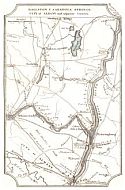
Main Author:
Atwood, J.M.
Title/Description:
Ballston & Saratoga Springs, City of Albany and Adjacent Country
Publication Info:
New York: 1839
Viewing Options
Main Author:
Greenleaf, Jeremiah
Title/Description:
New York
Publication Info:
Brattleboro, VT: J. Greenleaf, 1840; from Greenleaf's Universal Atlas
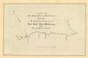
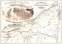
Viewing Options
Title/Description:
Outline of the Mohawk River & Wood Creek Showing the Relative Positions of Fort Bull, Fort Williams, and the German Flats
Publication Info:
Albany: Gavit & Duthie, c.1840
Viewing Options
Main Author:
Bradford, T.G. and S.G. Goodrich
Title/Description:
New York
Publication Info:
Boston: Charles D. Strong, 1841; from A Universal Atlas. Geographical, Statistical, and Historical View of the World
Viewing Options
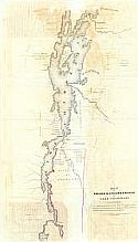
Main Author:
Brodhend, J. Romeyn
Title/Description:
Frontiers du Lac St. Sacrement 1758
Publication Info:
New York: D'avignon, 1842; copied from the original in the archives of the Depot General de la Guerre, Paris
Viewing Options
Main Author:
Morse, Sidney E.
Title/Description:
New York
Publication Info:
New York: Harper and Brothers, 1844; from The System of Geography for the Use of Schools
Viewing Options
Main Author:
Tanner, Henry Schenck
Title/Description:
A New Map of New York with Its Canals, Roads, and Distances from Place to Place along Stage and Steamboat Routes
Publication Info:
Philadelphia: H.S. Tanner, 1846; Last Edition of Tanner
Viewing Options
Main Author:
Mitchell, S. Augustus
Title/Description:
A New Map of New York
Publication Info:
Philadelphia: S. Augustus Mitchell, 1847; from The New Universal Atlas
Viewing Options
Main Author:
Blackwell, E.R.
Title/Description:
Trigonometrical Survey of the Falls of Niagara
Publication Info:
New York: Endicott and Co., c.1848; Executed for the Geological Reports of the Fourth District
Viewing Options
Main Author:
Sauthier, Claude Joseph
Title/Description:
A Chorographical Map of the Province of New York in North America
Publication Info:
Albany: 1849; 1849 reduction of 1779 map by Sauthier
Viewing Options
Title/Description:
Map of French and English Grants on Lake Champlain
Publication Info:
Albany: Richard H. Pease, 1849
Viewing Options
Main Author:
Goodrich, S.G.
Title/Description:
New York
Publication Info:
New York: George Savage, 1850; from A Comprehensive Geography and History Ancient and Modern
Viewing Options
Main Author:
Thomas, Cowperthwait and Co.
Title/Description:
A New Map of New York with Its Canals, Roads, and Distances
Publication Info:
Philadelphia: Thomas Cowperthwait & Co., 1850
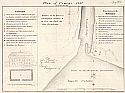
Viewing Options
Main Author:
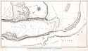
Chaussegros de Lery
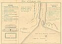
Title/Description:
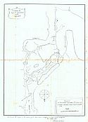
Plan of Oswego, 1727
Publication Info:
Albany: Gavit and Duthie, c.1850; from a manuscript originally done in Montreal, July 1727
Viewing Options
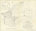
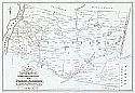
Title/Description:
A Map of a Tract of Land in the State of New York called Macomb's Purchase
Publication Info:
Albany: Weed, Parsons & Co., 1850; compiled from the official returns under the inspection of the Surveyor General by Charles C Brodhead; a large tract on the St. Lawrence River of 3,760,715 acres
Viewing Options
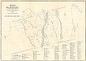
Main Author:
Gavit, John and John R. Bleeker
Title/Description:
A Map of the Manor of Renselaerwick (Surveyed and Laid Down by a Scale of 100 chains to an Inch by John R. Bleeker, Surveyor, 1767.)
Publication Info:
Albany: Weed, Parsons & Co., 1850; copied from the original by David Vaughn
Viewing Options
Main Author:
Wigram, John
Title/Description:
A Map of the Towns of Livingston, Germantown, and Clermont in the County of Columbia
Publication Info:
Albany: Weed, Parson & Co., 1850; compiled from the actual surveys in January 1798; copied from the original by David Vaughn and Augustus Tolle
Viewing Options
Main Author:
Chaussegros de Lery, Gaspard - Joseph
Title/Description:
Plan of Oswego 1727
Publication Info:
Albany: Gavit & Duthie, c.1850; from Paris Doc VIII; from a manuscript originally done in Montreal, July 1727
Viewing Options
Main Author:
Seaver's Steamship Printing Establishment
Title/Description:
Northern Route U.S. Mail Line and American Express Line -- Routes from Albany to Niagara Falls, Buffalo and Montreal
Publication Info:
Buffalo: Seaver's Steamship Printing Establishment, c.1850

