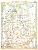
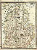
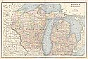
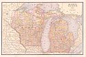
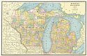
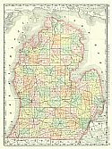
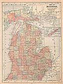
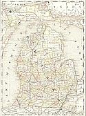
Viewing Options
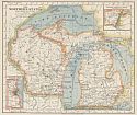
Main Author:
Rand McNally and Company
Title/Description:
Michigan
Publication Info:
Chicago: Rand McNally and Company, 1881; from New Indexed Business Atlas and Shippers Guide
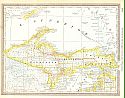
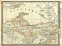
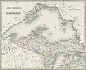
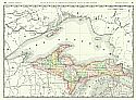
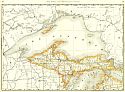
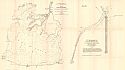
Viewing Options
Main Author:
Rand McNally and Company
Title/Description:
Northern Michigan and Lake Superior
Publication Info:
Chicago: Rand McNally and Company, 1881; from New Indexed Business Atlas and Shippers Guide
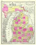
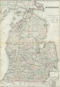
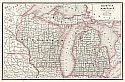
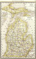
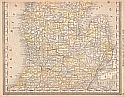
Viewing Options
Main Author:
Tunison, Henry C.
Title/Description:
Tunison's Michigan
Publication Info:
Jacksonville, IL: H.C. Tunison, c.1882
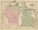
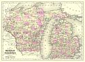
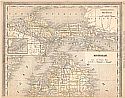
Viewing Options
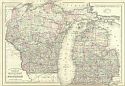
Main Author:
McNally, Francis
Title/Description:
Michigan and Wisconsin
Publication Info:
Chicago: A.S. Barnes and Company, 1882; from McNally's System of Geography
Viewing Options
Main Author:
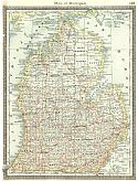
Hardesty, H.H.
Title/Description:
Map of North Michigan and Lake Superior
Publication Info:
New York: H.H. Hardesty & Co., 1883; from Hardesty's Historical and Geographical Encyclopedia
Viewing Options
Main Author:
Hardesty, H.H.
Title/Description:
Map of Michigan
Publication Info:
New York: H.H. Hardesty & Co., 1883; from Hardesty's Historical and Geographical Encyclopedia
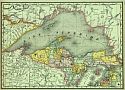
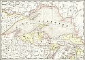
Viewing Options
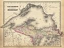
Main Author:
O.W. Gray and Son
Title/Description:
Lake Superior and the Northern Part of Michigan
Publication Info:
Philadelphia: O.W. Gray and Son, 1883; from The National Atlas
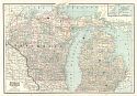
Viewing Options
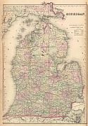
Main Author:
O.W. Gray and Son
Title/Description:
Michigan
Publication Info:
Philadelphia: O.W. Gray and Son, 1883; from The National Atlas
Viewing Options
Title/Description:
Northern States, Eastern Section
Publication Info:
Cincinatti: Van Antwerb, Bragg and Company, 1883; from The Eclectic Complete Geography
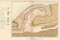
Viewing Options
Main Author:
U.S. Geological Survey
Title/Description:
Geological Map of the Porcupine Mountains, Michigan
Publication Info:
Washington: Department of the Interior, U.S. Geological Survey, 1883; Monograph 5 Plate 19
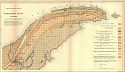
Viewing Options
Main Author:
U.S. Geological Survey
Title/Description:
Geological Map of Keweenaw Point, Michigan
Publication Info:
Washington: Department of the Interior, U.S. Geological Survey, 1883; Monograph 5 Plate 17

Viewing Options
Main Author:
Watson, Gaylord
Title/Description:
Michigan (Upper Peninsula)
Publication Info:
Boston: Perry and Spaulding, 1883; from New Indexed Family Atlas of the United States with Maps of the World
Viewing Options
Main Author:
Watson, Gaylord
Title/Description:
Michigan (Lower Peninsula)
Publication Info:
Boston: Perry and Spaulding, 1883; from New Indexed Family Atlas of the United States with Maps of the World
Viewing Options
Main Author:
Hardesty, H.H.
Title/Description:
Map of Northern Michigan and Lake Superior
Publication Info:
New York: H.H. Hardesty and Company, 1884; from Hardesty's Historical and Geographical Encyclopedia
Viewing Options
Main Author:
Hardesty, H.H.
Title/Description:
Map of Michigan
Publication Info:
New York: H.H. Hardesty and Company, 1884; from Hardesty's Historical and Geographical Encyclopedia
Viewing Options
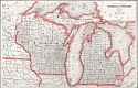
Main Author:
Cram, George F.
Title/Description:
Michigan and Wisconsin
Publication Info:
Chicago: Henry S. Stebbins, 1884; from The Unrivaled Family Atlas of the World
Viewing Options
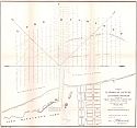
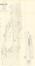
Main Author:
U.S. Army Corps of Engineers
Title/Description:
Plan for a Harbor of Refuge at Ludington, Michigan
Publication Info:
Washington: U.S. Senate, 48th Congress, 1st session, Doc. No. 81, 1884
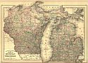
Viewing Options
Main Author:
Watson, Gaylord
Title/Description:
Michigan and Wisconsin
Publication Info:
New York: Gaylord Watson, 1885; from Watson's New and Complete Illustrated Atlas of the World
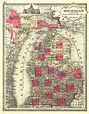
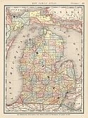
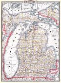
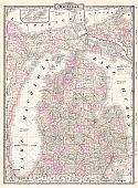
Viewing Options
Main Author:
Tunison, Henry Cuthbert
Title/Description:
Michigan
Publication Info:
Jacksonville, IL: H.C. Tunison, 1885
Upper Peninsula
Michigan
Main Author:
Rand McNally and Company
Title/Description:
Michigan
Publication Info:
Chicago: Rand McNally and Co., 1885; from The Standard Atlas of the World
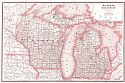
Viewing Options
Main Author:
Mitchell, S. Augustus
Title/Description:
County and Township map of the States of Michigan and Wisconsin
Publication Info:
Philadelphia: Wm. M. Bradley and Bro., 1886
Viewing Options
Title/Description:
Lake Superior and the Northern Part of Michigan
Publication Info:
Philadelphia: Stedman and Brown, 1886; from The National Atlas
Viewing Options
Title/Description:
Michigan
Publication Info:
Philadelphia: Stedman and Brown, 1886; from The National Atlas
Viewing Options
Main Author:
Cram, George F.
Title/Description:
Michigan and Wisconsin
Publication Info:
Chicago: George F. Cram, 1886; from Cram's Unrivaled Family Atlas of the World
Viewing Options
Main Author:
Cram, George F.
Title/Description:
Michigan and Wisconsin
Publication Info:
Chicago: George F. Cram, 1887
Viewing Options
Main Author:
Mitchell Jr., S. Augustus
Title/Description:
County and Township Map of the States of Michigan and Wisconsin
Publication Info:
Philadelphia: Bradley and Bro., 1887; from Mitchell's New General Atlas
Viewing Options
Title/Description:
Michigan
Publication Info:
New York: A. A. Grant, 1887; from Grant's Standard American Atlas of the World
Viewing Options
Main Author:
The Peoples Publishing Company
Title/Description:
Michigan and Wisconsin
Publication Info:
Chicago: The Peoples Publishing Company, 1887; from The Peoples Unrivaled Family Atlas of the World
Viewing Options
Main Author:
Rand McNally & Company
Title/Description:
Northern Michigan
Publication Info:
Chicago: Rand McNally & Co., 1888; from Rand McNally's Indexed Atlas of the World
Viewing Options
Main Author:
Rand McNally & Company
Title/Description:
Southern Michigan
Publication Info:
Chicago: Rand McNally & Co., 1888; from Rand McNally's Indexed Atlas of the World
Viewing Options
Main Author:
People's Publishing Co.
Title/Description:
Michigan and Wisconsin
Publication Info:
Rochester: W.H. Stewart & Co., 1888; from The Peoples' Illustrated & Descriptive Family Atlas of the World
Viewing Options
Main Author:
Johnson, Alvin J.
Title/Description:
Map of Michigan and Wisconsin
Publication Info:
New York: A.J. Johnson & Co., c.1889; Drawn and Engraved on Copper-Plate Expressly for Johnson's Cyclopedia
Viewing Options
Main Author:
Rand McNally & Company
Title/Description:
Rand McNally & Co.'s Northern Portion of Michigan
Publication Info:
Chicago: Rand McNally & Co., c1889
Viewing Options
Main Author:
Mast, Crowell & Kirkpatrick
Title/Description:
Map of Michigan
Publication Info:
Springfield, Ohio: Mast, Crowell, & Kirkpatrick, 1889; from The Peerless Atlas of the World
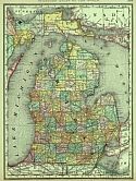
Viewing Options
Main Author:
Rand McNally and Company
Title/Description:
Michigan
Publication Info:
Chicago: Rand McNally and Co., 1889; from The Enlarged Business Atlas and Shippers Guide
Viewing Options
Main Author:
US Army Corps of Engineers
Title/Description:
Detroit River from Lake Erie to Lake St. Clair
Publication Info:
Washington: US Senate, 1889; Senate Document 52, 50th Congress, 2nd Session
Viewing Options
Main Author:
US Army Corps of Engineers
Title/Description:
Chart of Lake St. Clair
Publication Info:
Washington: US Senate, 1889; Senate Document 52, 50th Congress, 2nd Session
Viewing Options
Main Author:
Rand McNally & Co.
Title/Description:
Michigan
Publication Info:
Chicago: Rand McNally & Co., 1890; from Rand McNally & Co.'s Family Atlas of the World
Viewing Options
Main Author:
Rand McNally & Co.
Title/Description:
Michigan
Publication Info:
Chicago: Rand McNally & Co., 1890; from Rand McNally & Co.'s Family Atlas of the World
Viewing Options
Viewing Options
Main Author:
Alden, John B.
Title/Description:
Michigan
Publication Info:
New York: John B. Alden, 1890; from The Home Atlas of the World
Viewing Options
Main Author:
Cram, George F.
Title/Description:
Michigan and Wisconsin
Publication Info:
Rochester: W.H. Stewart, c. 1890; from Cram's Unrivaled Atlas of the World
Viewing Options
Main Author:
Walker, Henry B.
Title/Description:
Michigan
Publication Info:
Philadelphia: H.B. Walker, 1890; from Walker's International Atlas

