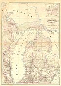
Viewing Options
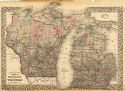
Main Author:
Asher and Adams
Title/Description:
Michigan
Publication Info:
New York: Asher and Adams, 1872; from New Statistical Atlas of the United States
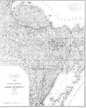
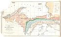
Viewing Options
Main Author:
Brooks, T.B.
Title/Description:
Map of the Central Portion of the Upper Peninsula, Michigan
Publication Info:
Geological Survey of Michigan, 1873
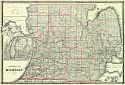
Viewing Options
Main Author:
Chapman and and Silas
Title/Description:
Sectional Map of Michigan, 1873
Publication Info:
Chicago: Chapman & Silas, 1873
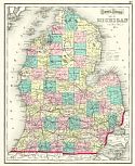
Viewing Options
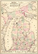
Main Author:
Colton, Joseph Hutchins
Title/Description:
Gray's Atlas Map of Michigan
Publication Info:
Philadelphia: O.W. Gray, 1873
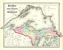
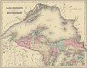
Viewing Options
Main Author:
Colton, Joseph Hutchins
Title/Description:
Gray's Atlas Map of Lake Superior and the Northern Part of Michigan No. 2
Publication Info:
Philadelphia: O.W. Gray, 1873
Viewing Options
Main Author:
Gray, Ormando W.
Title/Description:
New Railroad Map of Michigan
Publication Info:
Philadelphia: O.W. Gray
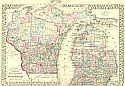
Viewing Options
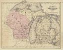
Main Author:
McNally, Francis
Title/Description:
Michigan and Wisconsin
Publication Info:
Chicago: A.S. Barnes and Company, 1873; from An Improved System of Geography
Viewing Options
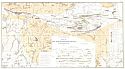
Main Author:
Brooks, T.B.
Title/Description:
Map of the Upper Peninsula
Publication Info:
Geological Survey of Michigan, 1873; from the Atlas Accompanying Reports on Upper Peninsula, Plate I
Viewing Options
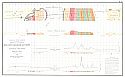
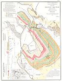
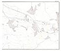
Main Author:
Brooks, T.B.
Title/Description:
Magneto-Geological Chart of Republic Mountain, Marquette Co., Michigan
Publication Info:
Geological Survey of Michigan, 1873; from the Atlas Accompanying Reports on Upper Peninsula, Plate II
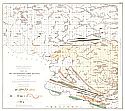
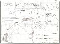
Viewing Options
Main Author:
Brooks, T.B.
Title/Description:
Map of the Marquette Iron Region Upper Peninsula, Michigan
Publication Info:
Geological Survey of Michigan, 1873; from the Atlas Accompanying Reports on Upper Peninsula, Plate III
Viewing Options
Main Author:
Brooks, T.B.
Title/Description:
Map of the Menominee Iron Region, Upper Peninsula, Michigan
Publication Info:
Geological Survey of Michigan, 1873; from the Atlas Accompanying Reports on Upper Peninsula, Plate IV
Viewing Options
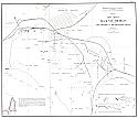
Main Author:
Brooks, T.B.
Title/Description:
Map of Iron Mines at Negaunee, Michigan, including the Jackson and the Hematile Mines
Publication Info:
Geological Survey of Michigan, 1873; from the Atlas Accompanying Reports on Upper Peninsula, Plate V
Viewing Options
Main Author:
Brooks, T.B.
Title/Description:
Map of the Republic Mountain and Vicinity, Marquette Co., Michigan
Publication Info:
Geological Survey of Michigan, 1873; from the Atlas Accompanying Reports on Upper Peninsula, Plate VI
Viewing Options
Main Author:
Brooks, T.B.
Title/Description:
Map of Champion Mine, Marquette Co., Michigan
Publication Info:
Geological Survey of Michigan, 1873; from the Atlas Accompanying Reports on Upper Peninsula, Plate VII
Viewing Options
Main Author:
Brooks, T.B.
Title/Description:
Map of Washington and Edwards Mines. Humboldt, Marquette Co., Michigan
Publication Info:
Geological Survey of Michigan, 1873; from the Atlas Accompanying Reports on Upper Peninsula, Plate VIII
Viewing Options
Main Author:
Brooks, T.B.
Title/Description:
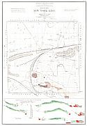
Map of Lake Superior Mine. Marquette Co., Michigan
Publication Info:
Geological Survey of Michigan, 1873; from the Atlas Accompanying Reports on Upper Peninsula, Plate IX
Viewing Options
Main Author:
Brooks, T.B.
Title/Description:
Map of the New York Mine of Marquette Co., Michigan
Publication Info:
Geological Survey of Michigan, 1873; from the Atlas Accompanying Reports on Upper Peninsula, Plate X
Viewing Options
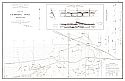
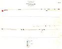
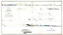
Main Author:
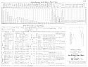
Brooks, T.B.
Title/Description:
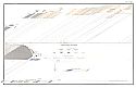
Statistics of the Iron Ore Trade and Iron Ore Mines of the Upper Peninsula
Publication Info:
Geological Survey of Michigan, 1873; from the Atlas Accompanying Reports on Upper Peninsula, Plate XII
Viewing Options
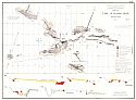
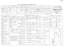
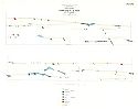
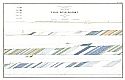
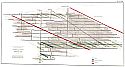
Main Author:
Brooks, T.B.
Title/Description:
Furnaces Consuming L.S. Ores Production of Pig Iron. Metallurgical Chemical Character of the Ores
Publication Info:
Geological Survey of Michigan, 1873; from the Atlas Accompanying Reports on Upper Peninsula, Plate XIII
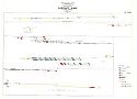
Viewing Options
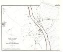
Main Author:
Brooks, T.B.
Title/Description:
Map to Accompany the Cross Sections of the Portage Lake District (Part I)
Publication Info:
Geological Survey of Michigan, 1873; from the Atlas Accompanying Reports on Upper Peninsula, Plate XIVa
Viewing Options
Main Author:
Brooks, T.B.
Title/Description:
Map to Accompany the Cross Sections of the Portage Lake District (Part 2)
Publication Info:
Geological Survey of Michigan, 1873; from the Atlas Accompanying Reports on Upper Peninsula, Plate XIVb
Viewing Options
Main Author:
Brooks, T.B.
Title/Description:
Cross Sections Near Portage Lake South Shore, No. I
Publication Info:
Geological Survey of Michigan, 1873; from the Atlas Accompanying Reports on Upper Peninsula, Plate XV
Viewing Options
Main Author:
Brooks, T.B.
Title/Description:
Cross Sections Near Portage Lake South Shore, No. II
Publication Info:
Geological Survey of Michigan, 1873; from the Atlas Accompanying Reports on Upper Peninsula, Plate XVI
Viewing Options
Main Author:
Brooks, T.B.
Title/Description:
Cross Sections Near Portage Lake South Shore, No. III
Publication Info:
Geological Survey of Michigan, 1873; from the Atlas Accompanying Reports on Upper Peninsula, Plate XVII
Viewing Options
Main Author:
Brooks, T.B.
Title/Description:
Cross Sections Near Portage Lake South Shore, No. IV
Publication Info:
Geological Survey of Michigan, 1873; from the Atlas Accompanying Reports on Upper Peninsula, Plate XVIII
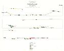
Viewing Options
Main Author:
Brooks, T.B.
Title/Description:
Grouped Cross Sections Illustrating Certain Stratigraphical Relations Between Houghton and Keweenaw Counties
Publication Info:
Geological Survey of Michigan, 1873; from the Atlas Accompanying Reports on Upper Peninsula, Plate XIX
Viewing Options
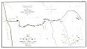
Main Author:
Brooks, T.B.
Title/Description:
Map to Accompany the Cross Sections of the Eagle River District
Publication Info:
Geological Survey of Michigan, 1873; from the Atlas Accompanying Reports on Upper Peninsula, Plate XX
Viewing Options
Main Author:
Brooks, T.B.
Title/Description:
Cross Sections of the Eagle River District, No. I
Publication Info:
Geological Survey of Michigan, 1873; from the Atlas Accompanying Reports on Upper Peninsula, Plate XXI
Viewing Options
Main Author:
Brooks, T.B.
Title/Description:
Cross Sections of the Eagle River District, No. II
Publication Info:
Geological Survey of Michigan, 1873; from the Atlas Accompanying Reports on Upper Peninsula, Plate XXII
Viewing Options
Main Author:
Brooks, T.B.
Title/Description:
Geological Section in the Central Mine
Publication Info:
Geological Survey of Michigan, 1873; from the Atlas Accompanying Reports on Upper Peninsula, Plate XXIII
Viewing Options
Main Author:
Mitchell, S. Augustus
Title/Description:
County and Township Map of the States of Michigan and Wisconsin
Publication Info:
Philadelphia: S. A. Mitchell, 1873; from Mitchell's New General Atlas
Viewing Options
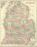
Main Author:
Gray, Ormando W.
Title/Description:
Michigan No. 1
Publication Info:
Philadelphia: O.W. Gray and Son, 1876; from Gray's National Atlas with Descriptions
Viewing Options
Main Author:
Gray, Ormando W.
Title/Description:
Lake Superior and the Northern part of Michigan
Publication Info:
Philadelphia: O.W. Gray and Son, 1876; from Gray's National Atlas with Descriptions
Viewing Options
Main Author:
Gamble, William H.
Title/Description:
County and Township Map of the States of Michigan and Wisconsin
Publication Info:
Philadelphia: S.A. Mitchell, Jr., c.1880

