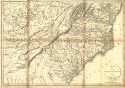
Viewing Options
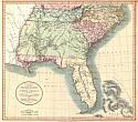
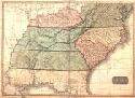
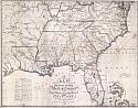
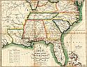
Main Author:
Russell, John C.
Title/Description:
Map of the Southern Provinces of the United States
Publication Info:
[London]: Printed for R. Philips [18--?]
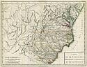
Viewing Options
Main Author:
Tardieu, Antoine Francois
Title/Description:
Carte de la Caroline
Publication Info:
[Paris: P.G. Chanlaire and E. Mentelle, 1797, 1801]; from Mentelle and Chanlaire's Atlas Universal de géographie physique et politique
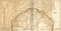
Viewing Options
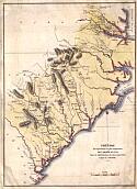
Main Author:
Bradley, Abraham
Title/Description:
Map of the Southern Parts of the United States of America
Publication Info:
unknown publisher, [1804]
Viewing Options
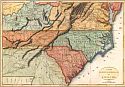
Main Author:
Bradley, Abraham
Title/Description:
Map of the Southern Parts of the United States of America
Publication Info:
Boston: 1804, published in Morse's American Gazetteer
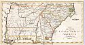
Viewing Options
Title/Description:
A New Map of Part of the United States of North America
Publication Info:
London: John Cary, 1806
Viewing Options
Main Author:
Marshall, John
Title/Description:
Theâtre des Opérations les plus importantes de L'Armée de Sud
Publication Info:
[Paris: Dentu, 1807]; from his Vie de George Washington
Viewing Options
Main Author:
Marshall, John
Title/Description:
Carte des Provinces meridionales des Etats-Unis
Publication Info:
Paris: 1807
Original Source:
Courtesy of Tom McMillan; Brewton, Alabama
Viewing Options
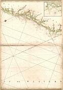
Main Author:
Deposito Hidrografico de Marina
Title/Description:
Carte Particular de las Costas Sententrionales del Seno Mexicano
Publication Info:
Madrid: Spanish Admirality, 1807; from Carta Esfenica
Original Source:
Courtesy of Tom McMillan; Brewton, Alabama
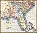
Viewing Options
Main Author:
Pinkerton, John
Title/Description:
United States of America, Southeastern Part
Publication Info:
London: Cadell & Davies, Strand S. Longman, Hurst Rees and Crane, 1809; from Pinkerton's Modern Atlas
Viewing Options
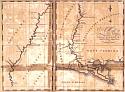
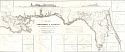
Main Author:
Schultz, Christian
Title/Description:
Map of the Mississippi River
Publication Info:
Newark: P. Maverick, [1810?]
Viewing Options
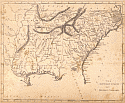
Main Author:
Carey, Mathew
Title/Description:
The Southern States and Mississippi Territory
Publication Info:
Philadelphia: Johnson and Warner, 1810
Viewing Options
Main Author:
Carey, Mathew
Title/Description:
The Southern States and Mississippi Territory
Publication Info:
Philadelphia, c.1812
Viewing Options
Main Author:
Melish, John
Title/Description:
A Map of the Southern Section of the United States including The Floridas and Bahama Islands Showing the Seat of War in that Department
Publication Info:
Philadelphia: John Melish, 1813; from his A Military and Topographical Atlas of the United States
Viewing Options
Viewing Options
Viewing Options
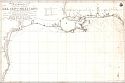
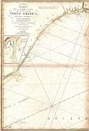
Main Author:
Steel and Company
Title/Description:
Steel's New and Correct Chart of the Coast of North America from Cape Canaveral to Cape Hatteras
Publication Info:
London: Steel and Co., 1813
Viewing Options
Main Author:
Melish, John
Title/Description:
A Map of the Southern Section of the United States including the Floridas & Bahama Islands showing the Seat of War in the Department
Publication Info:
Philadelphia: John Melish, 1813
Original Source:
Courtesy of Tom McMillan; Brewton, Alabama
Viewing Options
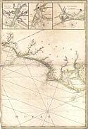
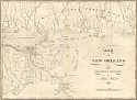
Main Author:
Melish, John
Title/Description:
Map of New Orleans and Adjacent Country
Publication Info:
Philadelphia: 1815
Original Source:
Courtesy of Tom McMillan; Brewton, Alabama
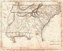
Viewing Options
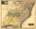
Main Author:
Thomson, John
Title/Description:
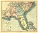
Southern Provinces of the United States
Publication Info:
[Edinburgh]: J. Thomson and Company, 1817
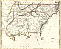
Viewing Options
Main Author:
Carey, Mathew
Title/Description:
The Southern States and Mississippi Territory
Publication Info:
[Philadelphia: Carey and Warner, 1817]
Viewing Options
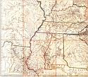
Main Author:
Arrowsmith, Aaron
Title/Description:
[Untitled map of South-Central United States]
Publication Info:
London: 1796; map is dated 1796, but is apparently a later edition showing the political situation of c.1817
Viewing Options
Title/Description:
A New Map of Part of the United States of North America
Publication Info:
London: John Cary, 1819
Viewing Options
Title/Description:
Map of the Territory of Florida from its Northern Boundary to Latitude 27 30' N, connected with the delta of the Mississippi
Publication Info:
Washington DC: Board of Internal Improvement, 1819
Original Source:
Courtesy of Tom McMillan; Brewton, Alabama
Viewing Options
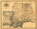
Main Author:
Morse, Sidney Edwards
Title/Description:
Alabama, Mississippi, and Louisiana
Publication Info:
N. and S.S. Jocelyn, 1822
Viewing Options
Title/Description:
New Map of Part of the United States of North America
Publication Info:
London: John Cary, 1825
Viewing Options
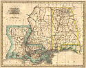
Title/Description:
Alabama, Mississippi, and Louisiana
Publication Info:
[New Haven: N and S.S. Jocelyn, 1825]

