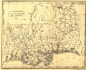
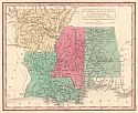
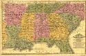
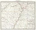
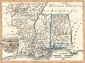
Viewing Options
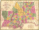
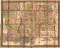
Main Author:
Drayton, James
Title/Description:
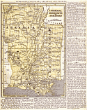
Mississippi, Alabama and Louisiana
Publication Info:
S.1. : s.n., 1826
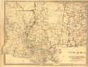
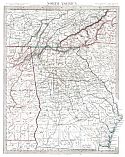
Viewing Options
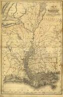
Main Author:
Vance, DH and JH Young
Title/Description:
Map of Louisiana, Mississippi and Alabama, constructed from the latest authorities
Publication Info:
Philadelphia: A. Finley, 1826
Original Source:
Courtesy of Tom McMillan; Brewton, Alabama
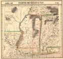
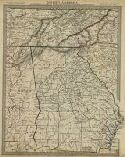
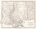
Viewing Options
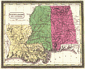
Main Author:
Vandermaelen, Philippe Marie Guillaume
Title/Description:
Partie Des Etats Unis
Publication Info:
Bruxelles: 1827;Plate 56 from Volume 4 of Vandermaelen World Atlas
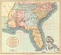
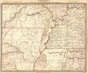
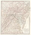
Viewing Options
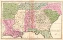
Title/Description:
A New Map of Part of the United States of North America
Publication Info:
London: John Cary, 1828; from his Univeral Atlas
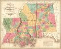
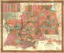
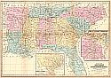
Viewing Options
Main Author:
Mitchell, Samuel Augustus
Title/Description:
Map of Louisiana, Mississippi, and Alabama
Publication Info:
Philadelphia: S.A. Mitchell, 1831
Viewing Options
Main Author:
Hinton, Isaac Taylor
Title/Description:
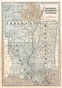
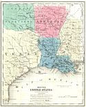
Map of the States of Mississippi, Louisiana, and the Arkansas territory
Publication Info:
London: I.T. Hinton, Simpkin and Marshall, 1832
Viewing Options
Main Author:
Williams, Calvin S.
Title/Description:
Mississippi, Alabama, and Louisiana
Publication Info:
[New Haven: cS. Williams, 1832]
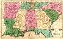
Viewing Options
Main Author:
Huntington, F.J.
Title/Description:
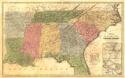
Southern States
Publication Info:
Hartford: F.J. Huntington, 1832
Original Source:
Courtesy of Whitney Telle, Northport, Alabama
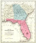
Viewing Options
Title/Description:
Alabama, Mississippi, Louisiana, and Arkansas Territory
Viewing Options
Main Author:
Society for the Difusion of Useful Knowledge
Title/Description:
North American Sheet XIII Parts of Louisiana, Arkansas, Mississippi, Alabama & Florida
Publication Info:
London: Baldwin & Cradock, 1833
Viewing Options
Main Author:
Society for the Diffusion of Useful Knowledge
Title/Description:
North America sheet XII Georgia with parts of North & South Carolina, Tennessee, Alabama & Florida
Publication Info:
London: Baldwin & Cradock, 1833
Viewing Options
Main Author:
Society for the Diffusion of Useful Knowledge
Title/Description:
North America Sheet X Parts of Missouri, Illinois, Kentucky, Tennessee, Alabama, Mississippi and Arkansas
Publication Info:
London: Baldwin & Cradock, 1833
Viewing Options
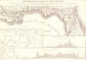
Main Author:
Poussin, Guillaume
Title/Description:
Carte Generale de la Floride et du Delta Mississippi
Publication Info:
Paris: Libraire Cariliant Goeury, 1834
Original Source:
Courtesy of Tom McMillan; Brewton, Alabama
Viewing Options
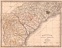
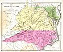
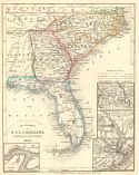
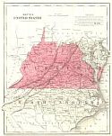
Main Author:
Bradford, Thomas Gamaliel
Title/Description:
North Carolina, South Carolina, and Georgia
Publication Info:
Boston: American Stationer's Co., 1835; from his Comprehensive Atlas Geographical, Historical, and Commericial
Viewing Options
Main Author:
Smith, Randall, C.
Title/Description:
Southern States
Publication Info:
[Philadelphia: W. Marshall, 1835]; from his Atlas for Schools, Academies, and Families
Viewing Options
Main Author:
Mitchell, Samuel Augustus
Title/Description:
Map of the States of North Carolina, South Carolina and Georgia
Publication Info:
Philadelphia: S.A. Mitchell, 1836
Viewing Options
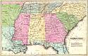
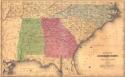
Main Author:
Mitchell, Samuel Augustus
Title/Description:
Map of the Southern States of Louisiana, Mississippi, and Alabama
Publication Info:
Philadelphia: S.A. Mitchell, 1837
Viewing Options
Main Author:
Olney, Jesse
Title/Description:
Southern States
Publication Info:
New York: Robinson, Pratt and Co., 1837; from New and Improved School Atlas
Viewing Options
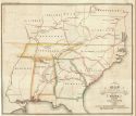
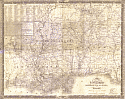
Main Author:
Trautwine, John Cresson
Title/Description:
Map Illustrative of the Internal Improvement System of the South
Publication Info:
Philadelphia: Journal of the Franklin Institute, 1837; Vol. 23
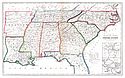
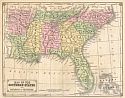
Viewing Options
Main Author:
Evans, W. Gardner
Title/Description:
The Southern States
Publication Info:
New York: F.J. Huntington, 1838
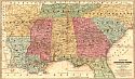
Viewing Options
Main Author:
Mitchell, Samuel Augustus
Title/Description:
Map of the Chief Part of the Southern States and Part of the Western
Publication Info:
[Philadelphia: Thomas Cowperthwait & Company., 1839]
Viewing Options
Main Author:
Mitchell, Samuel Augustus
Title/Description:
Map of the Southern States of Louisiana, Mississippi, and Alabama
Publication Info:
Philadelphia: S.A. Mitchell, 1839

Viewing Options
Main Author:
Smith, Randall C.
Title/Description:
Map of the Southern States
Publication Info:
[Hartford]: Stiles, Sherman and Smith, 1839; to accompany Smith's Geography for Schools
Viewing Options
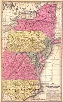
Main Author:
Mitchell, Samuel Augustus
Title/Description:
Map of the Middle States and part of the Southern
Publication Info:
Philadelphia: S.A. Mitchell, 1839
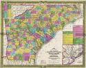
Viewing Options
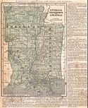
Title/Description:
Map of the States of Louisiana, Mississippi and Alabama
Publication Info:
Philadelphia: S.A. Mitchell, 1839

Viewing Options
Main Author:
Mitchell, S. Augustus
Title/Description:
No. 8 Map of the Chief Part of the Southern States and Part of the Western
Publication Info:
Philadelphia: Thomas, Cowperthwait and Co., 1839; from Mitchell's School Atlas
Viewing Options
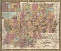
Main Author:
Mitchell, Samuel Augustus
Title/Description:
Map of the States of Louisiana, Mississippi, and Alabama
Publication Info:
Philadelphia: S.A. Mitchell, 1842
Viewing Options
Main Author:
Woodbridge, William C.
Title/Description:
Political Map of the Southern Division of the United States
Publication Info:
Hartford: Belknap and Hamersley, 1843; from School Atlas, to accompany the Modern School Geography
Viewing Options
Main Author:
Olney, Jesse
Title/Description:
Southern States
Publication Info:
New York: Sherman and Smith, 1844; from Olney's School Geography
Viewing Options
Title/Description:
Map of the Southern States
Publication Info:
Hartford: John Paine, 1844; from Smith's Atlas designed to accompany the Geography for Schools
Viewing Options
Main Author:
Morse, Sidney E.
Title/Description:
Louisiana, Mississippi and Arkansas
Publication Info:
New York: Harper and Brothers, 1844; from The System of Geography for the Use of Schools
Viewing Options
Main Author:
Woodbridge, William Channing
Title/Description:
Physical and Political Map of the Southern Division of the United States
Publication Info:
Boston: W.C. Woodbridge, 1843; adapted to Woodbridges Geography
Viewing Options
Main Author:
Burgess, Daniel
Title/Description:
Louisiana, Mississippi, and Arkansas
Publication Info:
New York: Harper and Brothers, 1845
Viewing Options
Main Author:
Morse, Sidney Edwards
Title/Description:
Louisiana, Mississippi and Arkansas
Publication Info:
New York: Harper & Brothers, 1846
Viewing Options
Main Author:
Society for the Diffusion of Useful Knowledge
Title/Description:
North America Sheet X Parts of Missouri, Illinois, Kentucky, Tennessee, Alabama, Missouri and Arkansas
Publication Info:
London: Charles Knight & Co., 1846

Viewing Options
Main Author:
Society for the Diffusion of Useful Knowledge
Title/Description:
North America Sheet XI Parts of North and South Carolina
Publication Info:
London: Charles Knight & Co., 1846
Viewing Options
Main Author:
Society for the Diffusion of Useful Knowledge
Title/Description:
North America Sheet XII Georgia with Parts of North & South Carolina, Tennessee, Alabama & Florida
Publication Info:
London: Charles Knight & Co., 1846
Viewing Options
Main Author:
Society for the Diffusion of Useful Knowledge
Title/Description:
North America Sheet XIII Parts of Louisiana, Arkansas, Mississippi, Alabama & Florida
Publication Info:
London: Charles Knight & Co., 1846
Viewing Options
Main Author:
Society for the Diffusion of Useful Knowledge
Title/Description:
North America Sheet VII Pennsylvania, New Jersey, Maryland, Delaware, Columbia and Part of Virginia
Publication Info:
London: Charles Knight & Co., 1846
Viewing Options
Title/Description:
Die Staaten von Arkansas, Mississippi, Louisiana and Alabama
Publication Info:
Amsterdam: 1846
Viewing Options
Main Author:
Williams, Wellington
Title/Description:
Map of the Southern and South-Western States
Publication Info:
New York: D. Appleron & Co., 1849; Engraved to Accompany Appleton's Hand Book of American Travel
Viewing Options
Title/Description:
N. and S. Carolina, Georgia and Florida
Publication Info:
Hildburghausen: Bibliograph Instituts zu Hildburghausen, 1850; from Meyer's Zeitungs Atlas
Viewing Options
Main Author:
Smith, Roswell C.
Title/Description:
Map of the Southern States, and Arkansas & Tennessee
Publication Info:
New York: Daniel Burgess, c.1850
Viewing Options
Main Author:
Smith, Roswell C.
Title/Description:
Map No. 6 United Statse (Mississippi, Louisiana, Arkansas and Texas)
Publication Info:
New York: Cady and Burgess, 1850 from A Concise and Practical System of Geography for Common Schools, Academies and Families
Viewing Options
Main Author:
Smith, Roswell C.
Title/Description:
Map No. 5 United Statse (Alabama, Georgia, Florida and South Carolina)
Publication Info:
New York: Cady and Burgess, 1850 from A Concise and Practical System of Geography for Common Schools, Academies and Families
Viewing Options
Main Author:
Smith, Roswell C.
Title/Description:
Map No. 4 United States (Virginia and North Carolina)
Publication Info:
New York: Cady and Burgess, 1850 from A Concise and Practical System of Geography for Common Schools, Academies and Families

