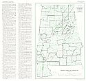
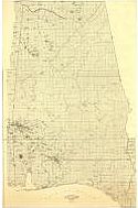
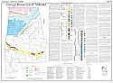
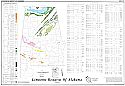
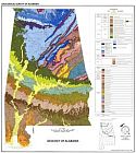
Viewing Options
Main Author:
U.S. Geological Survey
Title/Description:
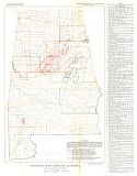
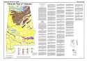
Geologic Map Index of Alabama
Publication Info:
Washington: Department of the Interior, U.S. Geological Survey, 1951
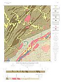
Viewing Options
Main Author:
Giffin, Robert H.
Title/Description:
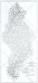
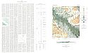
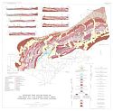
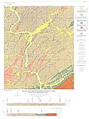
Geologic Map of a portion of the Hillabee Sill, Talladega Series and Ashland Mica Schist, Alabama
Publication Info:
Tuscaloosa: Geological Survey of Alabama, 1951; Bulletin 63
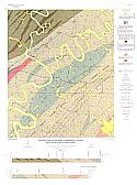
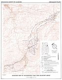
Viewing Options
Main Author:
Drennen, C.W.
Title/Description:
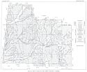
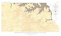
Geologic Map of Fayette and Lamar Counties, Alabama
Publication Info:
Washington: Department of the Interior, U.S. Geological Survey, 1953; Circular 267 Plate 1

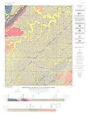
Viewing Options
Main Author:
Brackeen, L.G.
Title/Description:
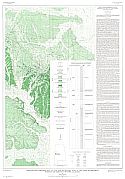
Ground Water, State of Alabama
Publication Info:
Montgomery: Alabama Department of Agriculture, 1955
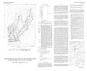
Viewing Options
Main Author:
Monreo, Watson H.
Title/Description:
Preliminary Geologic Map of the Nortwestern Part of the Epes Quadrangle, Sumter and Greene Counties, Alabama
Publication Info:
Washington: Department of the Interior, U.S. Geological Survey, 1955; Map OM 167
Viewing Options
Main Author:
Monreo, Watson H. and James L. Hunt
Title/Description:
Geologic Map of the Epes Quadrangle, Alabama
Publication Info:
Washington: Department of the Interior, U.S. Geological Survey, 1958
Viewing Options
Main Author:
U.S. Geological Survey
Title/Description:
Geologic Map of the Stone Hill Mine, Cleburne and Randolph Counties, Alabama
Publication Info:
Washington: Department of the Interior, U.S. Geological Survey, c.1963; Bulletin 1142-I, Plate 6
Viewing Options
Main Author:
Warren, W.C.
Title/Description:
Geologic Map of the Eufaula District, Barbour and Henry Counties, Alabama
Publication Info:
Washington: Department of the Interior, U.S. Geological Survey,, 1964; Bulletin 1199-E, Plate 1
Viewing Options
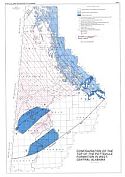
Main Author:
U.S. Geological Survey
Title/Description:
Geologic Map Showing Configuration of the Base of the Fort Payne Chert, Birmingham Red-Iron-Ore District, Alabama
Publication Info:
Washington: Department of the Interior, U.S. Geological Survey, 1965; Professional Paper 473-C, Plate 1
Viewing Options
Main Author:
U.S. Geological Survey
Title/Description:
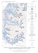
Geologic Map and Sections of the Rock Run and Goshen Valley Areas, Cherokee and Calhoun Counties, Alabama
Publication Info:
Washington: Department of the Interior, U.S. Geological Survey, 1966; Bulletin 1199-N, Plate 1
Viewing Options
Main Author:
Bergquist, Harlan R.
Title/Description:
Geologic Map of the Margerum Bauxite District, Colbert County, Alabama, showing some structure contours
Publication Info:
Washington: Department of the Interior, U.S. Geological Survey, 1966; Bulletin 1199-D, Plate 1
Viewing Options
Main Author:
Daniel, Thomas W., Jr. and Milton H. Fies
Title/Description:
Strippable Coal in the Fabius Area, Jackson County, Alabama
Publication Info:
Tuscaloosa: Geological Survey of Alabama, 1968
Viewing Options
Main Author:
Moore, Donald B.
Title/Description:
Subsurface Geologic Map of Southwest Alabama
Publication Info:
Tuscaloosa: Geological Survey of Alabama, 1970
Viewing Options
Main Author:
McIntosh, Willard L. and Margaret F. Eister
Title/Description:
Geologic Index of Alabama, 1971
Publication Info:
Washington: Department of the Interior, U.S. Geological Survey, 1973
Viewing Options
Main Author:
Neathery, Thornton L. and John W. Reynolds
Title/Description:
Geologic Map of the Lineville East Quadrangle, Alabama
Publication Info:
Tuscaloosa: Geological Survey of Alabama, 1974
Viewing Options
Main Author:
Neathery, Thornton L. and John W. Reynolds
Title/Description:
Geologic Map of the Ofelia Quadrangle, Alabama
Publication Info:
Tuscaloosa: Geological Survey of Alabama, 1974
Viewing Options
Main Author:
Neather, Thornton L. and John W. Reynolds
Title/Description:
Geologic Map of the Mellows Valley Quadrangle, Alabama
Publication Info:
Tuscaloosa: Geological Survey of Alabama, 1974
Viewing Options
Main Author:
Neathery, Thornton L. and John W. Reynolds
Title/Description:
Geologic Map of the Wadley North Quadrangle, Alabama
Publication Info:
Tuscaloosa: Geological Survey of Alabama, 1974
Viewing Options
Main Author:
Neather, T.L. and D.M. Self
Title/Description:
ERTS Lineament Map of the Piedmont of Alabama
Publication Info:
Tuscaloosa: Geological Survey of Alabama, 1974

Viewing Options
Main Author:
Beg, Mirza A. and I. David George
Title/Description:
Active Mines and Quarries of Alabama
Publication Info:
Tuscaloosa: Geological Survey of Alabama, 1975; Map 176, 1975 edition
Viewing Options
Main Author:
Szabo, Michael W.
Title/Description:
Calcium Carbonate Distribution within the Selma Group According to Surface Samples
Publication Info:
Tuscaloosa: Geological Survey of Alabama, 1976

Viewing Options
Main Author:
Beg, Mirza A. and Michael W. Szabo
Title/Description:
Calcium Carbonate Distribution within the units of the Selma Group containing more than 75 percent CCE according to drill hole samples
Publication Info:
Tuscaloosa: Geological Survey of Alabama, 1976
Viewing Options
Main Author:
Wilson, Gary V.
Title/Description:
Isopach, Smackover Formation
Publication Info:
Tuscaloosa: Geological Survey of Alabama, 1976
Viewing Options
Viewing Options
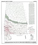
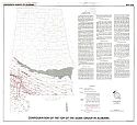
Main Author:
Kidd, Jack T.
Title/Description:
Configuration of the top of the Pottsville Formation in West-Central Alabama
Publication Info:
Tuscaloosa: State Oil and Gas Board of Alabama, 1976
Viewing Options
Main Author:
Wilson, G.U. and J.T. Kidd
Title/Description:
Structure - Top of Smackover Formation
Publication Info:
Tuscaloosa: Geological Survey of Alabama, 1976
Viewing Options
Main Author:
Geological Survey of Alabama
Title/Description:
State of Alabama Mineral Resources of Southwest Alabama
Publication Info:
Tuscaloosa: Geological Survey of Alabama, 1977; Map 180 SW
Viewing Options
Title/Description:
(Map Showing Oil and Gas Wells 1865-1976)
Publication Info:
unknown
Viewing Options
Main Author:
The Cartographic Research Laboratory
Title/Description:
Land-Use and Mineral Rights
Publication Info:
Department of Geography, The University of Alabama: 1978-1984
Viewing Options
Main Author:
Stover, C.W., B.G. Reagor and S.T. Algermissen
Title/Description:
Seismicity Map of the State of Alabama
Publication Info:
Washington: Department of the Interior, U.S. Geological Survey, 1979
Viewing Options
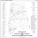
Main Author:
Davis, Marvin E.
Title/Description:
Generalized Geologic Map and Southern Extent of Major Use of Ground Waters from Principal Aquifers in Alabama
Publication Info:
Tuscaloosa: Geological Survey of Alabama, 1980
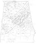
Viewing Options
Title/Description:
Structural Features of North Alabama
Publication Info:
Tuscaloosa: Geological Survey of Alabama, 1981
Viewing Options
Main Author:
Schweinfurth, Stanley P., Virgil A. Trent and Edward D. Helton
Title/Description:
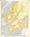
Geologic Map of the Sipsey Wilderness and Additions, Lawrence and Winston Counties, Alabama
Publication Info:
Washington: Department of the Interior, U.S. Geological Survey, 1981

Viewing Options
Main Author:
Markewich, Helaine W. and Christopher, Raymond A.
Title/Description:
Geologic Map of the La Place and Tuskeegee Quadrangles, Macon, Tallapoosa, and Elmore Counties, Alabama
Publication Info:
Washington: Department of the Interior, U.S. Geological Survey, 1982
Viewing Options
Main Author:
Wilson, Gary V.
Title/Description:
Isopach Map of the Hartselle Sadnstone
Publication Info:
Tuscaloosa: Geological Survey of Alabama, 1982

Viewing Options
Main Author:
Wilson, Gary V.
Title/Description:
Structure Contour Map of Top of the Hartselle Sandstone
Publication Info:
Tuscaloosa: Geological Survey of Alabama, 1982
Viewing Options
Main Author:
Wilson, Gary V.
Title/Description:
Structure on top of Smackover Formation
Publication Info:
Tuscaloosa: Geological Survey of Alabama, 1982

Viewing Options
Main Author:
Wilson, Gary V.
Title/Description:
Isopach Map of the Smackover Formation
Publication Info:
Tuscaloosa: Geological Survey of Alabama, 1982
Viewing Options
Main Author:
Smith, W. Everett, Garvy V. Wilson and Bennett L. Bearden
Title/Description:
Energy Resources of Alabama
Publication Info:
Tuscaloosa: Geological Survey of Alabama, 1983
Viewing Options
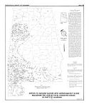
Main Author:
Osborne, Edward and Michael W. Szabo
Title/Description:
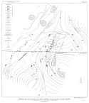
Geologic Map of Jacksonville Fault and Adjacent Areas
Publication Info:
Tuscaloosa: Geological Survey of Alabama, 1983; Circular 117, Plate 1

Viewing Options
Main Author:
Hinkle, Frank, H. Gene White and Richard Hamilton
Title/Description:
Generalized Map of Crude Oil, Petroleum Products, and Natural Gas Transmission Lines in Alabama
Publication Info:
Tuscaloosa: Geological Survey of Alabama, 1983
Viewing Options
Main Author:
Epsman, M.L., T.B. Moffett, Frank Hinkle, G.V. Wilson, and J.D. Moore
Title/Description:
Depth to Ground Waters with Approximately 10,000 Milligrams per Liter of Total Dissolved Solids in Parts of Alabama
Publication Info:
Tuscaloosa: Geological Survey of Alabama, 1983
Viewing Options
Main Author:
Hinkle, Frank, T.B. Moffett, M.L. Epsman, G.V. Wilson and J.D. Moore
Title/Description:
Configuration of the Top of the Eutaw Formation in Alabama
Publication Info:
Tuscaloosa: Geological Survey of Alabama, 1983
Viewing Options
Main Author:
Beg, Mirza A.
Title/Description:
Limestone Resources in Alabama
Publication Info:
Tuscaloosa: Geological Survey of Alabama, 1984; Map 172

Viewing Options
Title/Description:
Oil and Gas Leases and Wells in Alabama State Waters and Adjacent Federal OCS Waters
Publication Info:
Tuscaloosa: Geological Survey of Alabama, 1984

Viewing Options
Main Author:
Mink, Robert M.
Title/Description:
Oil and Gas Leases and Wells in Alabama State Waters and Adjacent Federal OCS Waters
Publication Info:
Tuscaloosa: State Oil and Gas Board of Alabama, 1984
Viewing Options
Main Author:
Smith, Everett
Title/Description:
Minerals Map of Alabama
Publication Info:
Tuscaloosa: Geological Survey of Alabama, 1984
Viewing Options
Main Author:
Moffett, T.B., Frank Hinkle, M.L. Epsman and G.V. Wilson
Title/Description:
Configuration of the Top of the Selma Group in Alabama
Publication Info:
Tuscaloosa: Geological Survey of Alabama, 1984

Viewing Options
Main Author:
Moffett, T.B., Frank Hinkle, M.L. Epsman, G.V. Wilson and J.D. Moore
Title/Description:
Configuration of the Top of the Tuscaloosa Group in Alabama
Publication Info:
Tuscaloosa: Geological Survey of Alabama, 1984
Viewing Options
Main Author:
Robinson, Gilpin R. Jr., Terry L. Klein and Frank G. Lesure
Title/Description:
Geologic Map of the Adams Gap and Shinbone Creek Areas, Clay County, Alabama
Publication Info:
Washington: Department of the Interior, U.S. Geological Survey
Viewing Options
Main Author:
Hinkle, Frank and Thomas A. Sexton
Title/Description:
Generalized Map of Crude Oil, Petroleum Products, and National Gas Transmission Lines in Alabama
Publication Info:
Tuscaloosa: State Oil and Gas Board of Alabama, 1985
Viewing Options
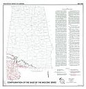
Main Author:
Moore, James D. and Dorothy E. Raymond
Title/Description:
Configuration of the Base of the Mocene Series
Publication Info:
Tuscaloosa: Geological Survey of Alabama, 1985
Viewing Options
Main Author:
Mink, Robert M. and Bennett L. Bearden
Title/Description:
Oil and Gas Leases and Wells in Alabama State Coastal Water and Adjacent Federal OCS Waters
Publication Info:
Tuscaloosa: State Oil and Gas Board of Alabama, 1986

Viewing Options
Main Author:
Burroughs, Dolores and Gary W. Crawford
Title/Description:
Energy Resources and Generalized Transmission Systems in Alabama
Publication Info:
Tuscaloosa: Geological Survey of Alabama, 1987
Viewing Options
Title/Description:
Oil and Gas Fields in Alabama
Publication Info:
Tuscaloosa: Geological Survey of Alabama, 1987
Viewing Options
Viewing Options
Viewing Options
Viewing Options
Main Author:
Geological Survey of Alabama
Title/Description:
Oil and Gas Fields in Alabama
Publication Info:
Tuscaloosa: Geological Survey of Alabama, 1987
Viewing Options
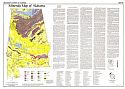
Main Author:
Geological Survey of Alabama
Title/Description:
Geology of Alabama
Publication Info:
Tuscaloosa: Geological Survey of Alabama, 1989

Viewing Options
Main Author:
Oglesby, Howell R. and James D. Moore
Title/Description:
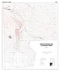
Selected Wells and Springs in Northwest Alabama
Publication Info:
Tuscaloosa: Geological Survey of Alabama, 1989
Viewing Options

Viewing Options
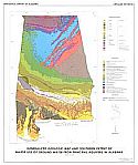
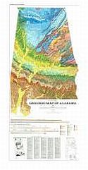
Main Author:
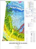
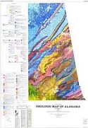
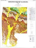
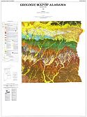
Osborne, W. Edward, Michael W. Szabo, Charles W. Copeland and Thornton L. Neathery
Title/Description:
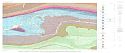
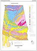
Geologic Map of Alabama
Publication Info:
Tuscaloosa: State Oil and Gas Board of Alabama, 1989, Special Map 221
Viewing Options
Main Author:
Hinkle, Frank and Thomas A. Sexton
Title/Description:
Depth to Ground Water in West-Central Alabama with approximately 10,000 milligrams per liter of total dissolved solids
Publication Info:
Tuscaloosa: Geological Survey of Alabama, 1992

Viewing Options
Main Author:
Guthrio, Gregory M.
Title/Description:
Photo-Lineament Map of Landsat Imagery, Alabama Piedmont
Publication Info:
Tuscaloosa: Geological Survey of Alabama, 1993

Viewing Options
Main Author:
Szabo, Michael W. and Sam H. Patterson
Title/Description:
Geologic Maps of the Big Sandy, West Elliots Creek and Reed Brake Roadless Areas, Tuscaloosa, Hale and Bibb Counties, Alabama
Publication Info:
Washington: Department of the Interior, U.S. Geological Survey, 1993
Viewing Options
Main Author:
Lesure, Frank G.
Title/Description:
Geochemical Reconnaissance of the Blue Hill and Gregory Hill Gold Mines and Vicinity, Tallapoosa County, Alabama
Publication Info:
Washington: Department of the Interior, U.S. Geological Survey, 1993
Viewing Options
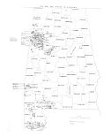
Main Author:
Dean, Lewis S.
Title/Description:
Minerals Map of Alabama
Publication Info:
Tuscaloosa: Geological Survey of Alabama, 1994

Viewing Options
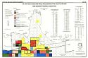
Main Author:
Pashin, Jack C. and Richard E. Carroll, Robert L. Barnett and Mirza A. Beg
Title/Description:
Geology and Coal Resources of the Cahaba Coal Field
Publication Info:
Tuscaloosa: Geological Survey of Alabama, 1995; Bulletin 163 Plate 1
Viewing Options
Main Author:
Moore, James D.
Title/Description:
Aquifers in Alabama
Publication Info:
Tuscaloosa: Geological Survey of Alabama, 1998
Viewing Options
Main Author:
Moore, James D.
Title/Description:
Comparison of Ground Water Provinces with Physiographic Regions of Alabama
Publication Info:
Tuscaloosa: Geological Survey of Alabama, 1998

Viewing Options
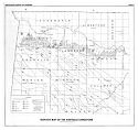
Main Author:
Wilson, Gary V. and Isidore Zietz
Title/Description:
Aeromagnetic Map of Alabama
Publication Info:
Tuscaloosa: State Oil and Gas Board of Alabama, 2002