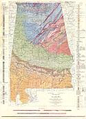
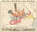
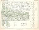
Viewing Options
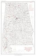
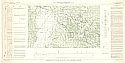
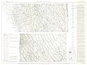
Main Author:
Alabama Geological Survey in cooperation with the U.S. Geological Survey, George W. Stose, ed.
Title/Description:
Geological Map of Alabama
Publication Info:
Tuscaloosa: Alabama Geological Survey, 1926
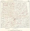
Viewing Options
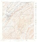
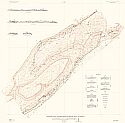
Main Author:
Semmes, D.R.
Title/Description:
Geologic Structure Map of Cedar Creek Valley, Fanklin Co., Alabama

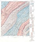
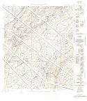
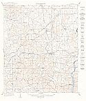
Viewing Options
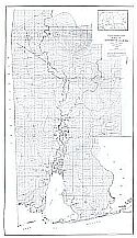
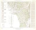
Main Author:
Semmes, D.R.
Title/Description:
Geologic Structure Map of a portion of Lawrence, Co., Alabama
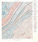
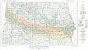
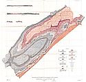
Areal Geology
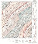
Economic Geology
Structure Geology
Topography
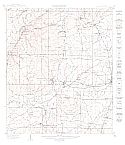
Main Author:
U.S. Geological Survey
Title/Description:
Bessemer (Folio 221)
Publication Info:
Washington: Department of the Interior, U.S. Geological Survey, 1927
Areal Geology
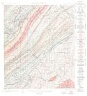
Economic Geology
Structure Geology

Topography
Main Author:
U.S. Geological Survey
Title/Description:
Vandiver (Folio 221)
Publication Info:
Washington: Department of the Interior, U.S. Geological Survey, 1927
Viewing Options
Main Author:
Barksdale, Jake
Title/Description:
Map of Alabama Showing Location of Wells Drilled for Oil and Gas
Publication Info:
Washington: Department of the Interior, U.S. Geological Survey, 1929

Viewing Options
Main Author:
Semmes, Douglas R.
Title/Description:
Structure Contours on Pratt Seam over Southeast Portion of Warrior Coal Field
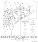
Viewing Options
Main Author:
Semmes, D.R.
Title/Description:
Sketch Map of the Southeastern part of Wilcox Co., Showing the Bethel Fault and the Lower Peach Tree Anticline

Viewing Options
Main Author:
Jones, Water B.
Title/Description:
Sketch Map of the Wattsville Basin, a part of the Coosa Coal Field, St. Clair County, Alabama
Publication Info:
Tuscaloosa: Geological Survey of Alabama, 1929; Figure 1 Circular
Viewing Options
Main Author:
Tennessee Coal, Iron and Railroad Company
Title/Description:
General Structural Map, Warrior and Cahaba Coal Fields
Publication Info:
Tennessee Coal, Iron, Railroad Company, Land Department, 1929
Viewing Options
Main Author:
Compiled by the Industrial Department of the Railroad
Title/Description:
Geological Map Showing Mineral Resources Along Central of Georgia Railroad
Publication Info:
Buffalo: The Matthews-Northrup Works, 1930
Viewing Options
Main Author:
Johnson, William Drumm, Jr.
Title/Description:
Map of Northern Alabama Showing Location of Wells and Springs Described in County Tables
Publication Info:
Tuscaloosa: Geological Survey of Alabama, 1930; from Special Report 16, Plate 33
Viewing Options
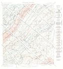
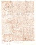
Main Author:
U.S. Geologcial Survey
Title/Description:
Cottondale Quadrangle
Publication Info:
Washington: Department of the Interior, U.S. Geological Survey, 1931; provisional sheet
Viewing Options
Main Author:
Burchard, Ernest F.
Title/Description:
Map of Greasy Cove and vicinity, Alabama, showing outcrop of iron-ore beds in Red Mountain District
Publication Info:
Washington: Department of the Interior, U.S. Geological Survey, 1933; Circular I Plate I
Viewing Options
Title/Description:
Magnetic Map of Southwest Alabama
Publication Info:
Tuscaloosa: Geological Survey of Alabama, 1936; Bulletin 43

Viewing Options
Main Author:
Bureau of Mines
Title/Description:
Principal Productive Coal Areas of Alabama
Publication Info:
Bureau of Mines, 1938
Viewing Options
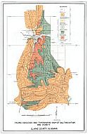
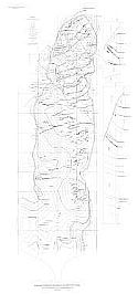
Main Author:
Toulmin, Lyman D., Jr.
Title/Description:
Geologic and Topographic Map of Salt Mountain and Vicinity, Clarke County, Alabama
Publication Info:
Tuscaloosa: Geological Survey of Alabama, 1940; Bulletin 46
Areal Geology
Structure Geology
Topography
Main Author:
U.S. Geological Survey
Title/Description:
Columbiana (Folio 226)
Publication Info:
Washington: Department of the Interior, U.S. Geological Survey, 1940
Areal Geology
Economic Geology
Structure Geology
Topography
Main Author:
U.S. Geological Survey
Title/Description:
Bessemer (Folio 221)
Publication Info:
Washington: Department of the Interior, U.S. Geological Survey, 1927
Viewing Options
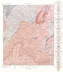
Main Author:
Monroe, W.H.
Title/Description:
Geological Map of the Upper Cretaceous Formations in Central Alabama
Publication Info:
Tuscaloosa: Geological Survey of Alabama, 1941; Bulletin 48, Plate 1
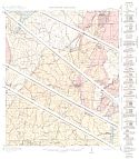
Viewing Options
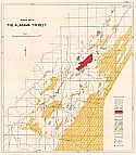
Main Author:
Hunter, Frank R.
Title/Description:
Geological Map of the Alabama Tin Belt
Publication Info:
Tuscaloosa: Geological Survey of Alabama, 1944; Bulletin 54

Viewing Options
Main Author:
Tourtelot, Harry A.
Title/Description:
Quitman Fault Zone, Clarke and Wayne Counties, Mississippi, and Choctaw County, Alabama
Publication Info:
Washington: Department of teh Interior, U.S Geological Survey, 1944
Viewing Options
Main Author:
MacNeil, F. Stearns
Title/Description:
The Midway and Wilcox Stratigraphy of Alabama and Mississippi
Publication Info:
Washington: Department of the Interior, U.S. Geological Survey, [1945]; from Strategic Minerals Investigations Preliminary Maps 3-195
Viewing Options
Main Author:
Conant, Louis C. and Watson H. Monroe
Title/Description:
Geologic Map of Tuscaloosa and Cottondale Quadrangles, Alabama Showing Area Geology and Structures of Upper Cretaceous Formations
Publication Info:
Washington: Department of the Interior, U.S. Geological Survey, 1945; from Oil and Gas Investigations Preliminary Map 37
Viewing Options
Main Author:
U.S. Geological Survey
Title/Description:
Geologic map and Sections of Greasy Cove, Alabama
Publication Info:
Washington: Department of the Interior, U.S. Geolgical Survey, 1945
Viewing Options
Main Author:
U.S. Geological Survey
Title/Description:
Geologic Map and Sections of Greasy Cove, Alabama
Publication Info:
Washington: Department of the Interior, U.S. Geological Survey, 1945
Viewing Options
Main Author:
U.S. Geological Survey
Title/Description:
Geologic Map of the Aliceville, Mantua, and Eutaw Quadrangles, Alabama; showing Pre-Selma Upper Cretaceous Formations
Publication Info:
Washington: Department of the Interior, U.S. Geological Survey, 1946
Viewing Options
Main Author:
U.S. Geological Survey
Title/Description:
Geologic Map of the Tertiary Formations of Alabama
Publication Info:
Washington: Department of the Interior, U.S. Geological Survey, 1946; Oil and Gas Investigations, Preliminary Map 45
Viewing Options
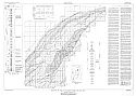
Main Author:
Eangle, D. Hope
Title/Description:
Correlation of the Pre-Selma Upper Cretaceous Formations between Tuscaloosa County, Alabama and Neshoba County, Mississippi
Publication Info:
Washington: Department of the Interior, U.S. Geological Survey, 1945; Oil and Gas Investigations, Preliminary Chart 20
Viewing Options
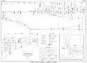
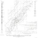
Main Author:
Rothrock, Howard E.
Title/Description:
Map of the Northeast End of the Coal City Basin, St. Clair County, Alabama Showing Structure and Mined-Out Areas of the Marion and Coal City Coal Beds
Publication Info:
Washington: Bureau of Mines, 1946; Technical Paper 719 Figure 23
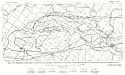
Viewing Options
Main Author:
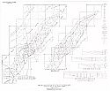
Eaigle, D. Hoye
Title/Description:
Profiles Showing Geology Along Highways in the Vicinity of Tuscaloosa, Alabama
Publication Info:
Washington: Department of the Interior, U.S. Geological Survey, 1947
Viewing Options
Main Author:
U.S. Geological Survey
Title/Description:
Pre-Selma Upper Cretaceous Stratigraphy in the McCrary, McShan, Gordo, Samantha, and Searles Quadrangles, Alabama and Mississippi
Publication Info:
Washington: Department of the Interior, U.S. Geological Survey, 1947
Viewing Options
Main Author:
Rothrock, Howard E.
Title/Description:
Map of the Coal City and Fairview Basins, Coosa Coal Field, St. Clair County, Alabama Showing Coal Outcops and Structure
Publication Info:
Washington: Bureau of Mines, 1947; Technical Paper 719 Figure 22
Viewing Options
Main Author:
U.S. Geological Survey
Title/Description:
Geology of the Coal City and Fairview Basins, Coosa Coal Field, St. Clair County, Alabama
Publication Info:
Washington: Department of the Interior, U.S. Geological Survey, 1948
Viewing Options
Main Author:
U.S. Geological Survey
Title/Description:
Geologic Map and Sections of Hog Mountain
Publication Info:
Washington: Department of the Interior, U.S. Geological Survey, 1948; Professional Paper 213, Plate 57

Viewing Options
Main Author:
Eargle, D. Hoye
Title/Description:
Correlations of Pre-Selma Upper Cretaceous Rocks in Northeastern Mississippi and Northwestern Alabama
Publication Info:
Washington: Department of the Interior, U.S. Geological Survey, 1948; Oil and Gas Investigations, Preliminary Chart
Viewing Options
Main Author:
Rothrock, Howard E.
Title/Description:
Maps and Structure Sections of the Coal City and Fairview Basins, Coosa Coal Field, St. Clair County, Alabama, 1948
Publication Info:
Washington: Department of the Interior, U.S. Geological Survey, 1948

Viewing Options
Main Author:
Eargle, D. Hoye
Title/Description:
Geologic Map of the Selma Group in Eastern Alabama
Publication Info:
Washington: Department of the Interior, U.S. Geological Survey, 1950; Oil and Gas Investigations, Preliminary Map 105
Viewing Options
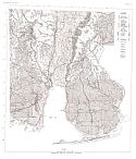
Main Author:
Carlston, Charles W.
Title/Description:
Geologic Map of Coastal Alabama
Publication Info:
Geological Society of America, 1950