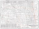
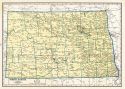
Viewing Options
Main Author:
Clason Map Company
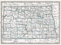
Title/Description:
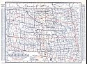
Best Roads of North Dakota
Publication Info:
Chicago: Clason Map Company, c. 1927; from Clason's Touring Atlas
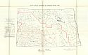
Viewing Options
Main Author:
U.S. Geological Survey
Title/Description:
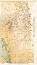
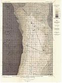
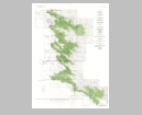
Geologic Map of Marmarth Lignite Field, Southwestern North Dakota
Publication Info:
Washington: Department of the Interior, U.S. Geological Survey, 1928; Bulletin 775 Plate 14
Viewing Options
Main Author:
U.S. Geological Survey
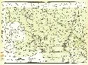
Title/Description:
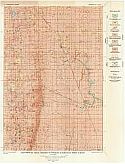
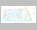
Map showing Areal Geology of Edgeley Quadrangle, North Dakota
Publication Info:
Washington: Department of the Interior, U.S. Geological Survey, 1929; Bulletin 801 Plate 1
Viewing Options
Main Author:
U.S. Geological Survey
Title/Description:
Map Showing Areal Geology of La Moure Quadrangle, North Dakota
Publication Info:
Washington: Department of the Interior, U.S. Geological Survey, 1929; Bulletin 801 Plate 2
Viewing Options
Main Author:
U.S. Geological Survey
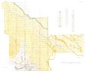
Title/Description:
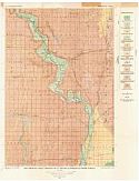
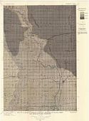
Map of Edgeley Quadrangle Showing Thickness of Glacial Drift and Artesian-Water Conditions
Publication Info:
Washington: Department of the Interior, U.S. Geological Survey, 1929; Bulletin 801 Plate 3
Viewing Options
Main Author:
U.S. Geological Survey
Title/Description:
Map of La Moure Quadrangle Showing Thickness of Glacial Drift and Artesian Water Conditions
Publication Info:
Washington: Department of the Interior, U.S. Geological Survey, 1929; Bulletin 801 Plate 4
Viewing Options
Main Author:
U.S. Geological Survey
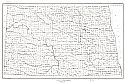
Title/Description:
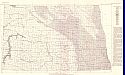
Map of North Dakota showing original areas of artesian flow
Publication Info:
Washington: Department of the Interior, U.S. Geological Survey, 1929; Water Supply Paper No. 598 Plate 1
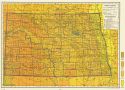
Viewing Options
Main Author:
National Map Company
Title/Description:
North Dakota
Publication Info:
Indianapolis: National Map Company, 1930; from Official Paved Road and Commercial Survey of the United States
Viewing Options
Main Author:
Clason Map Company
Title/Description:
Clason's Road Map of North Dakota
Publication Info:
Denver: The Clason Map Company, 1930; from Clason's Touring Atlas of the United States and Canada
Viewing Options
Main Author:
C.S. Hammond and Company
Title/Description:
North Dakota
Publication Info:
New York: C.S. Hammond and Company, c. 1930; from The New World Loose Leaf Atlas, Sixth Edition
Viewing Options
Main Author:
C.S. Hammond and Company
Title/Description:
North Dakota
Publication Info:
New York: C.S. Hammond and Company, c. 1930; from The New World Loose Leaf Atlas, Sixth Edition
Viewing Options
Main Author:
Geographical Publishing Company
Title/Description:
North Dakota
Publication Info:
Chicago: Geographical Publishing Company1931; from Commercial Atlas of the World
Viewing Options
Main Author:
Branom, Frederick K. and Lloyd Edwin Smith
Title/Description:
North Dakota
Publication Info:
Chicago: Geographical Publishing Company, 1936; from Capper's 1936 Atlas of the World
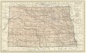
Viewing Options
Main Author:
Rand McNally and Company
Title/Description:
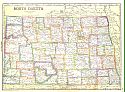
Standard Map of North Dakota
Publication Info:
Chicago: Rand McNally and Company, 1936
Viewing Options
Main Author:
U.S. Geological Survey
Title/Description:
Geologic map of the Minot Region, North Dakota
Publication Info:
Washington: Department of the Interior, US Geological Survey, 1938; Bulletin 906, Plate 11
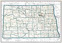
Viewing Options
Main Author:
U.S. Geological Survey
Title/Description:
State of North Dakota
Publication Info:
Washington: Department of the Interior, U.S. Geological Survey, 1939; compiled 1920
Viewing Options
Main Author:
Geographical Publishing Company
Title/Description:
North Dakota
Publication Info:
Chicago: Geographical Publishing Company, 1942; from The New International Atlas of the World, War Edition
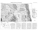
Viewing Options
Main Author:
Bureau of the Census
Title/Description:
North Dakota Irrigation by Drainage Basins, 1939
Publication Info:
Washington: U.S. Government Printing Office, 1942
Viewing Options
Main Author:
Hansen, Miller
Title/Description:
Preliminary Geologic Map of North Dakota
Publication Info:
Bismarck: North Dakota Geological Survey, 1952
Viewing Options
Main Author:
U.S. Geological Survey
Title/Description:
Map of Northern and North-Central Parts of Bowman Strippable Deposit in the Harmon Lignite Bed, Slope County, North Dakota
Publication Info:
Washington: Department of the Interior, U.S. Geological Survey, 1955; Bulletin 1015-E Plate 15
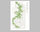
Viewing Options
Main Author:
U.S. Geological Survey
Title/Description:
Map of Southern and South-Central Parts of Bowman Strippable Deposit in the Harmon Lignite Bed, Slope and Bowman Counties, North Dakota
Publication Info:
Washington: Department of the Interior, U.S. Geological Survey, 1955; Bulletin 1015-E Plate 16
Viewing Options
Main Author:
U.S. Geological Survey
Title/Description:
Geologic Map of the Square Buttes Coal Field, Oliver and Mercer Counties, North Dakota
Publication Info:
Washington: Department of the Interior, U.S. Geological Survey, 1959; Bulletin 1076 Plate 1

