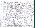
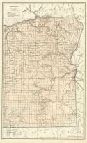
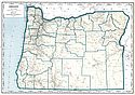
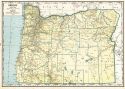
Viewing Options
Main Author:
Clason Map Company
Title/Description:
Best Roads of Oregon
Publication Info:
Chicago: Clason Map Company, c. 1927; from Clason's Touring Atlas
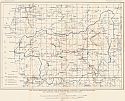
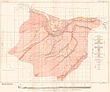
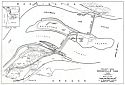
Viewing Options
Main Author:
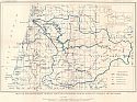
U.S. Geological Survey
Title/Description:
Map of Southwestern Oregon Showing Proposed Power Sites in Umpqua River Basin
Publication Info:
Washington: Department of the Interior, U.S. Geological Survey, 1929; Water Supply Paper No. 636 Plate 15
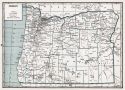
Viewing Options
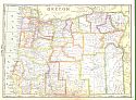
Main Author:
National Map Company
Title/Description:
Oregon
Publication Info:
Indianapolis: National Map Company, 1930; from Official Paved Road and Commercial Survey of the United States
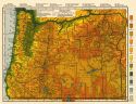
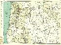
Viewing Options
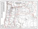
Main Author:
Clason Map Company
Title/Description:
Clason's Road Map of Oregon
Publication Info:
Denver: The Clason Map Company, 1930; from Clason's Touring Atlas of the United States and Canada
Viewing Options
Main Author:
C.S. Hammond and Company
Title/Description:
Oregon (Western Part)
Publication Info:
New York: C.S. Hammond and Company, c. 1930; from The New World Loose Leaf Atlas, Sixth Edition
Viewing Options
Main Author:
C.S. Hammond and Company
Title/Description:
Oregon (Eastern Part)
Publication Info:
New York: C.S. Hammond and Company, c. 1930; from The New World Loose Leaf Atlas, Sixth Edition
Viewing Options
Main Author:
C.S. Hammond and Company
Title/Description:
Oregon
Publication Info:
New York: C.S. Hammond and Company, c. 1930; from The New World Loose Leaf Atlas, Sixth Edition
Viewing Options
Main Author:
U.S. Geological Survey
Title/Description:
Map of Southwestern Oregon and Northwestern California Showing Developed and Proposed Power Sites in Rogue River Basin
Publication Info:
Washington: Department of the Interior, U.S. Geological Survey, 1931; Water Supply Paper No. 638 Plate 3
Viewing Options
Main Author:
U.S. Geological Survey
Title/Description:
Geologic Map of Middle Deschutes River Basin, Oregon
Publication Info:
Washington: Department of the Interior, U.S. Geological Survey, 1931; Water Supply Paper No. 637 Plate 10
Viewing Options
Main Author:
Geographical Publishing Company
Title/Description:
Oregon
Publication Info:
Chicago: Geographical Publishing Company1931; from Commercial Atlas of the World
Viewing Options
Main Author:
U.S. Geological Survey
Title/Description:
Geologic Map and Sections of the Dalles Region, Oregon, showing location of wells and springs
Publication Info:
Washington: Department of the Interior, U.S. Geological Survey, 1932; Water Supply Paper No. 659 Plate 11
Viewing Options
Main Author:
Branom, Frederick K. and Lloyd Edwin Smith
Title/Description:
Oregon
Publication Info:
Chicago: Geographical Publishing Company, 1936; from Capper's 1936 Atlas of the World
Viewing Options
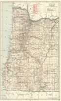
Main Author:
Rand McNally and Company
Title/Description:
Standard Map of Oregon
Publication Info:
Chicago: Rand McNally and Company, 1936
Viewing Options
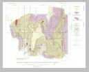
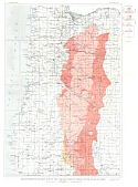
Main Author:
U.S. Geological Survey
Title/Description:
Reconnaissance Geologic Map of the Cascade Range in Oregon South of Mount Hood
Publication Info:
Washington: Department of the Interior, US Geological Survey, 1938; Bulletin 893, Plate 1
Viewing Options
Main Author:
U.S. Geological Survey
Title/Description:
Geologic Map and Structure Sections of the Bohemia District, Oregon
Publication Info:
Washington: Department of the Interior, US Geological Survey, 1938; Bulletin 893, Plate 13
Viewing Options
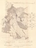
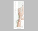
Main Author:
Ross, Clyde P.
Title/Description:
Geologic Map of part of the Wallowa Mountains, Oregon
Publication Info:
Portland: Department of Geology and Mineral Industries, 1938; Bulletin No. 3
Viewing Options
Main Author:
U.S. Coast and Geodetic Survey
Title/Description:
La Grande Sectional Aeronautical Chart
Publication Info:
Washington: U.S. Coast and Geodetic Survey, 1941
Viewing Options
Main Author:
Geographical Publishing Company
Title/Description:
Oregon
Publication Info:
Chicago: Geographical Publishing Company, 1942; from The New International Atlas of the World, War Edition
Viewing Options
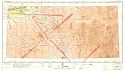
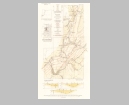
Main Author:
U.S. Army Corps of Engineers
Title/Description:
Project Area, Bonneville Dam
Publication Info:
Washington: War Department U.S. Army Corps of Engineers, 1946
Viewing Options
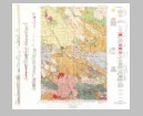
Main Author:
U.S. Geological Survey
Title/Description:
Geologic Map of Parts of the Empire and Bandon Quadrangles, Oregon, Showing Distribution of Terrace Deposits and Chromiferous Sands
Publication Info:
Washington: Department of the Interior, US Geological Survey, 1946; Bulletin 945-E, Plate 42

Viewing Options
Main Author:
U.S. Geological Survey
Title/Description:
Reconnaissance Map of Parts of the Steens and Pueblo Mountains, Harney County, Oregon
Publication Info:
Washington: Department of the Interior, U.S. Geological Survey, 1953; Bulletin No. 995
Viewing Options
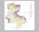
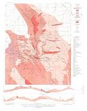
Main Author:
U.S. Geological Survey
Title/Description:
Geologic Map and Sections of Part of the Coos Bay Coal Field, Coos County, Oregon
Publication Info:
Washington: Department of the Interior, U.S. Geological Survey, 1953; Bulletin 982-B Plate 4
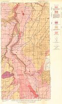
Viewing Options
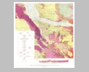
Main Author:
U.S. Geological Survey
Title/Description:
Geologic Map and Diagrammatic Section of Portland, Oregon and Adjacent Areas
Publication Info:
Washington: Department of the Interior, U.S. Geological Survey, 1963; Bulletin 1119 Plate 1
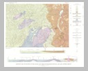
Viewing Options
Main Author:
U.S. Geological Survey
Title/Description:
Geologic Map and Sections of the Anlauf and Drain Quadrangles, Douglas and Lane Counties, Oregon
Publication Info:
Washington: Department of the Interior, U.S. Geological Survey, 1963; Bulletin 1122-D Plate 1