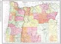
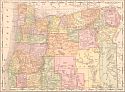
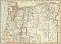
Viewing Options
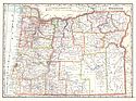
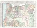
Main Author:
Rand McNally & Company
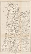
Title/Description:
Oregon
Publication Info:
Chicago: Rand McNally & Co., 1911
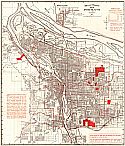
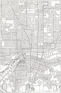
Viewing Options
Main Author:
Rowland and Fortiner
Title/Description:
Map of Portland and Vicinity
Publication Info:
Portland: Rowland and Fortiner, 1911
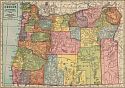
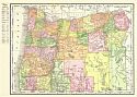
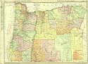
Viewing Options
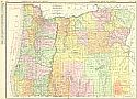
Main Author:
Geographical Publishing Company
Title/Description:
Oregon
Publication Info:
Chicago: The Geographical Publishing Company, 1911
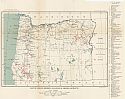
Viewing Options
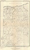
Main Author:
U.S. Geological Survey
Title/Description:
Reconnaissance Sketch Map of the Prospective Gas and Oil Field near Vale, Oreg. And Fayette, Idaho
Publication Info:
Washington: Department of the Interior, U.S. Geological Survey, 1911; Bulletin 431
Viewing Options
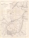
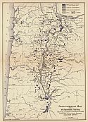
Title/Description:
Reconnaissance Map of the Willamette Valley showing available outcrops of road materials in the more densely populated portions
Publication Info:
Corvallis: The Oregon Bureau of Mines and Geology, 1911; Bulletin Number 1
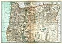
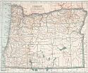
Viewing Options
Main Author:
Cram, George F.
Title/Description:
Oregon
Publication Info:
Chicago: George F. Cram, 1911; from Cram's Unrivaled Atlas of the World
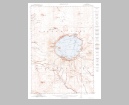
Viewing Options
Main Author:
U.S. Geological Survey
Title/Description:
Crater Lake National Park
Publication Info:
Washington: Department of the Interior, U.S. Geological Survey, 1911
Viewing Options
Main Author:
Rand McNally & Company
Title/Description:
The Rand McNally New Commercial Atlas Map of Oregon
Publication Info:
Chicago: Rand McNally & Co., 1912
Viewing Options
Main Author:
Rand McNally and Company
Title/Description:
Oregon
Publication Info:
Chicago: Rand McNally and Company, 1912; from The Rand McNally and Company's Imperial Atlas of the World
Viewing Options
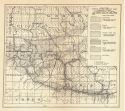
Main Author:
U.S. Geological Survey
Title/Description:
Map of Oregon, Showing Location of Mining Districts
Publication Info:
Washington: Department of the Interior, U.S. Geological Survey, 1912; Bulletin 507 Plate XI
Viewing Options
Main Author:
Rand McNally & Company
Title/Description:
Oregon
Publication Info:
Chicago: Rand McNally & Co., 1913
Viewing Options
Main Author:
The Century Company
Title/Description:
Oregon
Publication Info:
New York: The Century Company, 1913; from The Century Atlas of the World
Viewing Options
Main Author:
Cram, George F.
Title/Description:
Oregon
Publication Info:
Chicago: George F. Cram, 1913; from Cram's Unrivaled Atlas of the World
Viewing Options
Main Author:
Rand McNally and Company
Title/Description:
Oregon
Publication Info:
Chicago: Rand McNally and Co., 1914; from The Commercial Atlas of America
Viewing Options
Main Author:
Reynolds, Francis J.
Title/Description:
Oregon
Publication Info:
New York: P.F. Collier and Son, 1914; from The New Encyclopedic Atlas and Gazetteer of the World
Viewing Options
Main Author:
Reynolds, Francis J.
Title/Description:
Map of the City of Portland, Oregon
Publication Info:
New York: P.F. Collier and Son, 1914; from The New Encyclopedic Atlas and Gazetteer of the World
Viewing Options
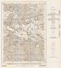
Main Author:
U.S. Geological Survey
Title/Description:
Map of Northwestern Oregon
Publication Info:
Washington: Department of the Interior, U.S. Geological Survey, 1914; from Bulletin 590 Plate I
Viewing Options
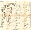
Main Author:
U.S. Geological Survey
Title/Description:
Map of Deschutes River Basin, Showing Position of Gaging Stations
Publication Info:
Washington: Department of the Interior, U.S. Geological Survey, 1914; Water Supply Paper No. 344 Plate 1
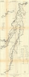
Main Author:
U.S. Geological Survey
Title/Description:
Plan and Profile of the Deschutes River, Columbia River to Pringle Falls, Oregon
Publication Info:
Washington: Department of the Interior, U.S. Geological Survey, 1914; from Water Supply Paper No. 344
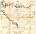
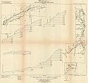
Main Author:
U.S. Geological Survey
Title/Description:
Plan and Profile of the Metolius River and Lane Creek, Oregon
Publication Info:
Washington: Department of the Interior, U.S. Geological Survey, 1914; from Water Supply Paper No. 244 Plate IVa-c
Viewing Options
Main Author:
Collier, A.J.
Title/Description:
Map of the Geology of the John Day Basin
Publication Info:
Corvallis: The Oregon Bureau of Mines and Geology, 1914; Vol 1. Number 3
Viewing Options
Main Author:
Pardee, J.T. and D.F. Heweet
Title/Description:
Generalized Geologic Map of Sumpter Quadrangle, Oregon
Publication Info:
Corvallis: The Oregon Bureau of Mines and Geology, 1914; Vol. 1 Number 6
Viewing Options
Main Author:
C.S Hammond and Company
Title/Description:
Oregon
Publication Info:
New York: C.S. Hammond and Company, 1914; from Hammond's Commercial and Library Atlas of the World