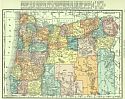
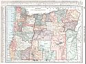
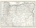
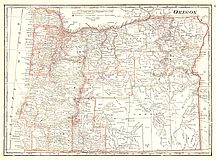
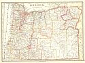
Viewing Options
Main Author:
Rand McNally and Company
Title/Description:
Oregon
Publication Info:
Chicago: Rand McNally and Co., 1916; from The Ideal Atlas of the World
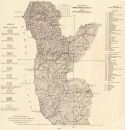
Viewing Options
Main Author:
Butler, G.M. and G.J. Mitchell
Title/Description:
Sketch Map of Curry County Oregon
Publication Info:
Corvallis: The Oregon Bureau of Mines and Geology, 1916; Vol. 2 Number 2
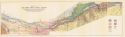
Viewing Options
Main Author:
Williams, Ira A
Title/Description:
Map of the Columbia River Gorge Region
Publication Info:
Corvallis: The Oregon Bureau of Mines and Geology, 1916; Vol. 2 Number 3
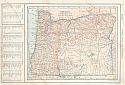
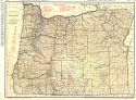
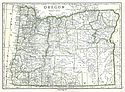
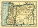
Viewing Options
Main Author:
Reynolds, Francis J.
Title/Description:
Oregon
Publication Info:
New York: P.F. Collier and Son, 1917; from The New Encyclopedia Atlas and Gazetteer of the World
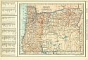
Viewing Options
Main Author:
C.S. Hammond and Company
Title/Description:
Oregon
Publication Info:
New York: C.S. Hammond and Company, 1918; from Hammonds Pictorial Atlas of the World
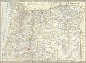
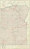
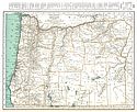
Viewing Options
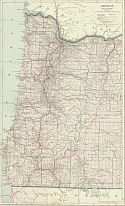
Main Author:
Rand McNally & Company
Title/Description:
The Rand McNally New Commercial Atlas Map of Oregon
Publication Info:
Chicago: Rand McNally & Co., 1920
Viewing Options
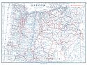
Main Author:
Reynolds, Francis J.
Title/Description:
Oregon
Publication Info:
New York: P.F. Collier and Son Company, 1920; from The New World Atlas and Gazetteer
Viewing Options
Main Author:
Cram, George F.
Title/Description:
Oregon
Publication Info:
Chicago: James R. Gray and Company, 1920; from Cram's Unrivaled Atlas of the World
Viewing Options
Main Author:
C.S. Hammond and Company
Title/Description:
Oregon
Publication Info:
New York: C.S. Hammond and Company, 1920; from The New Reference Atlas of the World
Original Source:
Courtesy of Shawn Carter
Viewing Options
Main Author:
Leslie-Judge Company
Title/Description:
Oregon
Publication Info:
New York: Leslie-Judge Company1920; from Leslie's New World Atlas
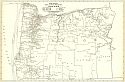
Viewing Options
Main Author:
Rand McNally and Company
Title/Description:
Oregon
Publication Info:
Chicago: Rand McNally and Company, 1921; from The Commercial Atlas of America
Viewing Options
Main Author:
Rand McNally and Company
Title/Description:
Oregon- Black and White Mileage Map
Publication Info:
Chicago: Rand McNally and Company, 1921; from The Commercial Atlas of America
Viewing Options
Main Author:
Cram, George F.
Title/Description:
Oregon
Publication Info:
Chicago: George F. Cram Company, 1921; from Cram's Unrivaled Atlas of the World
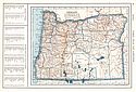
Viewing Options
Main Author:
National Map Company
Title/Description:
Oregon
Publication Info:
Indianapolis: National Map Company, 1921; from Auto Trails and Commercial Survey of the United States
Viewing Options
Main Author:
National Map Company
Title/Description:
Oregon
Publication Info:
Indianapolis: National Map Company, 1921; from Auto Trails and Commercial Survey of the United States
Western Part
Eastern Part
Main Author:
C.S. Hammond
Title/Description:
Oregon
Publication Info:
New York: C.S. Hammond and Company, 1922; from The New World Loose-leaf Atlas
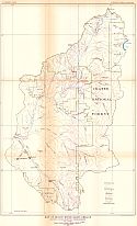
Viewing Options
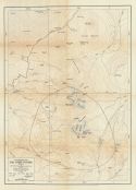
Main Author:
U.S. Geological Survey
Title/Description:
Map of Rogue River Basin, Oregon, Showing Hydro-Electric Developments
Publication Info:
Washington: Department of the Interior, U.S. Geological Survey, 1922; Water Supply Paper No. 493 Plate 18
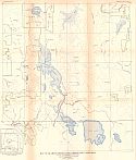
Viewing Options
Main Author:
U.S. Geological Survey
Title/Description:
Map of Kamath River Basin, Oregon and California, Showing Hydro-Electric Development
Publication Info:
Washington: Department of the Interior, U.S. Geological Survey, 1922; Water Supply Paper No. 493 Plate 15
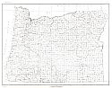
Viewing Options
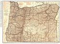
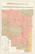
Main Author:
U.S. Geological Survey
Title/Description:
State of Oregon
Publication Info:
Washington: Department of the Interior, U.S. Geological Survey, 1923; compiled 1914, revised 1923, reprinted 1944
Viewing Options
Main Author:
Oregon Bureau of Mines and Geology
Title/Description:
Map of a Portion of Columbia County, Oregon Showing Topography, Geologic Formations and Location of Iron Ore Prospects
Publication Info:
Corvallis: The Oregon Bureau of Mines and Geology, 1923; Vol. 3 Number 3
Viewing Options
Main Author:
Cram, George F.
Title/Description:
Oregon
Publication Info:
Chicago: George F. Cram Company, 1923; from Cram's Unrivaled Atlas of the World
Viewing Options
Main Author:
Funk and Wagnalls Company
Title/Description:
Oregon
Publication Info:
New York: Funk and Wagnalls Company, 1923; from Atlas of the World and Gazetteer
Viewing Options
Main Author:
Reynolds, Francis J.
Title/Description:
Oregon
Publication Info:
New York: P.F. Collier and Son Company, 1924; from The New World Atlas and Gazetteer
Viewing Options
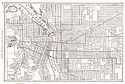
Main Author:
Reynolds, Francis J.
Title/Description:
Portland
Publication Info:
New York: P.F. Collier and Son Company, 1924; from The New World Atlas and Gazetteer
Viewing Options
Main Author:
Hodge, Edwin T.
Title/Description:
Topographic Map of the Three Sisters, Oregon
Publication Info:
Eugene: University of Oregon, 1925; from Mount Multnomah, Ancient Ancestor of the Three Sisters
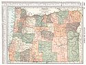
Viewing Options
Main Author:
Rand McNally and Company
Title/Description:
Oregon
Publication Info:
Chicago: Rand McNally and Company, 1925; from Premier Atlas of the World

