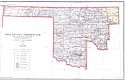
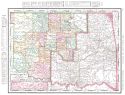
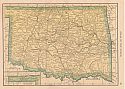
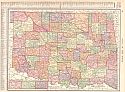
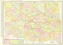
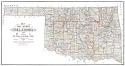
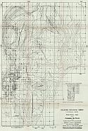
Viewing Options
Title/Description:
Map of Oklahoma Territory
Publication Info:
General Land Office, 1906
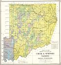
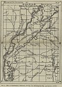
Viewing Options
Title/Description:
Creek and Seminole Nations Indian Territory
Publication Info:
Washington: Department of the Interior, Commissioner to the Five Civilized Tribes, 1906
Original Source:
Courtesy of Mike Berryhill; Henryetta, Oklahoma
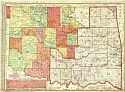
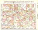
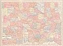
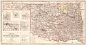
Viewing Options
Main Author:
Rand McNally and Company
Title/Description:
Oklahoma and Indian Territory
Publication Info:
Chicago: Rand McNally and Company, 1906; from the Business Atlas and Shippers Guide
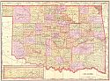
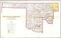
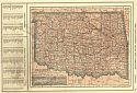
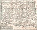
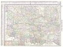
Viewing Options
Main Author:
Cram, George F.
Title/Description:
Oklahoma
Publication Info:
Chicago: George F. Cram, 1906; from Cram's Superior Reference Atlas
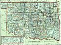
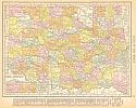
Viewing Options
Main Author:
Rand McNally and Company
Title/Description:
Oklahoma
Publication Info:
Chicago: Rand McNally and Company, 1906; from The World and its Peoples
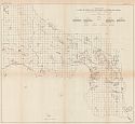
Viewing Options
Main Author:
Berthrong, I.P.
Title/Description:
Oklahoma Territory
Publication Info:
General Land Office, 1907
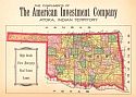
Viewing Options
Title/Description:
Oklahoma
Publication Info:
unknown: c.1907; The Compliments of the American Investment Company, Akota, Indian Territory; High Grade First Mortgage Real Estate Loans
Viewing Options
Main Author:
The Crowell Publishing Company
Title/Description:
Oklahoma
Publication Info:
New York: The Crowell Publishing Company, 1908; from The Twentieth Century Peerless Atlas
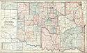
Viewing Options
Main Author:
Hammond, C.S.
Title/Description:
Oklahoma
Publication Info:
New York: C.S. Hammond & Co. 1908; from Hammond's Handy Atlas of the World
Viewing Options
Main Author:
Rand McNally and Company
Title/Description:
Oklahoma
Publication Info:
Chicago: Rand McNally and Company, 1908; from The New Ideal State and County Survey and Atlas
Viewing Options
Main Author:
Patten, William and J.E. Homas
Title/Description:
Oklahoma
Publication Info:
New York: P.F. Collier and Son, 1909; from The New Encyclopedic Atlas and Gazetteer of the World
Viewing Options
Main Author:
Cram, George F.
Title/Description:
Oklahoma
Publication Info:
Chicago: George F. Cram, c.1909; from The Heart of our Country
Viewing Options
Main Author:
Hammond, C.S.
Title/Description:
Oklahoma
Publication Info:
New York: C.S. Hammond and Company, 1909
Viewing Options
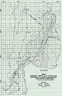
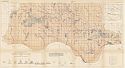
Main Author:
U.S. Geological Survey
Title/Description:
Map of Platt National Park, Murray County, Oklahoma
Publication Info:
Washington: Department of the Interior, U.S. Geological Survey, 1909
Viewing Options
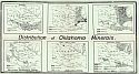
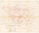
Main Author:
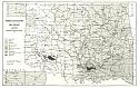
Oklahoma Geological Survey
Title/Description:
Distribution of Oklahoma Minerals
Publication Info:
Normal: Oklahoma Geological Survey, 1910; Bulletin No. 6
Viewing Options
Main Author:
Rand McNally and Company
Title/Description:
Oklahoma
Publication Info:
Chicago: Rand McNally and Company, 1910; from New Ideal State and County Survey
Viewing Options
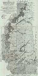
Main Author:
Gould, Charles N.
Title/Description:
Progress Geological Map of Oklahoma
Publication Info:
Norman: Oklahoma Geological Survey, 1911; from Bulletin No. 7
Viewing Options
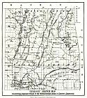
Main Author:
Oklahoma Geological Survey
Title/Description:
Geologic Sketch Map Illustrating Proposed Groups of the Pennsylvanian Rocks of Eastern Oklahoma
Publication Info:
Norman: Oklahoma Geological Survey, 1911; from Bulletin No. 7
Viewing Options
Main Author:
Cram, George F.
Title/Description:
Oklahoma
Publication Info:
Chicago: George F. Cram, 1911; from Cram's Unrivaled Atlas of the World
Viewing Options
Main Author:
Ravenstein, E.G.
Title/Description:
Oklahoma
Publication Info:
Chicago: The Reilly and Britton Company, 1911; from The New Census Atlas of the World
Viewing Options
Main Author:
Rand McNally and Company
Title/Description:
Oklahoma
Publication Info:
Chicago: Rand McNally & Co., 1912; from Rand McNally & Co.'s Library Atlas of the World
Viewing Options
Main Author:
Rand McNally and Company
Title/Description:
Oklahoma
Publication Info:
Chicago: Rand McNally and Company, 1912; from The Rand McNally Imperial Atlas of the World
Viewing Options
Main Author:
Oklahoma Geological Survey
Title/Description:
Map of Northeastern Oklahoma showing the Mississippi-Pennsylvania Contact
Publication Info:
Norman: Oklahoma Geological Survey, 1912; Bulletin No. 9
Viewing Options
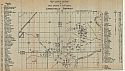
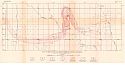
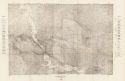
Main Author:
Oklahoma Geological Survey
Title/Description:
Map showing Location of Mills, Shafts, and Drill Holes, Lincolnville District
Publication Info:
Norman: Oklahoma Geological Survey, 1912; Bulletin No. 9
Viewing Options
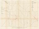
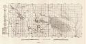
Main Author:
Oklahoma Geological Survey
Title/Description:
Map Showing Ponca City Anticline, Contours on Upper Surface of Herington Limestone
Publication Info:
Normal: Oklahoma Geological Survey, 1912; Bulletin No. 15
Viewing Options
Main Author:
The Century Company
Title/Description:
Oklahoma
Publication Info:
New York: The Century Company, 1913; from The Century Atlas of the World
Viewing Options
Main Author:
Cram, George F.
Title/Description:
Oklahoma
Publication Info:
Chicago: George F. Cram, 1913; from Cram's Unrivaled Atlas of the World
Viewing Options
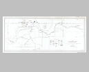
Main Author:
U.S. Geological Survey
Title/Description:
Map showing Oil and Gas Development in North-Central Oklahoma
Publication Info:
Washington Department of the Interior, U.S. Geological Survey, 1913; Bulletin 531 Plate V
Viewing Options
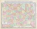
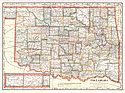
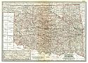
Main Author:
Oklahoma Geological Survey
Title/Description:
Map of the State of Oklahoma
Publication Info:
Norman: Oklahoma Geological Survey, 1914
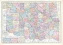
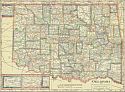
Viewing Options
Main Author:
Dinmore, A.F. and M. Hendges
Title/Description:
State of Oklahoma
Publication Info:
Washington: Department of the Interior, General Land Office, 1914
Viewing Options
Main Author:
Reynolds, Francis J.
Title/Description:
Oklahoma
Publication Info:
New York: P.F. Collier and Son, 1914; from The New Encyclopedic Atlas and Gazetteer of the World
Viewing Options
Main Author:
U.S. Geological Survey
Title/Description:
Reconnaissance Geologic Map of the Grandfield District, Oklahoma
Publication Info:
Washington: Department of the Interior, U.S. Geological Survey, 1914; Bulletin 547 Plate IV
Viewing Options
Main Author:
Oklahoma Geological Survey
Title/Description:
Structural Map of the Cushing Oil Field
Publication Info:
Norman: Oklahoma Geological Survey, 1914; Bulletin No. 18
Viewing Options
Main Author:
C.S Hammond and Company
Title/Description:
Oklahoma
Publication Info:
New York: C.S. Hammond and Company, 1914; from Hammond's Commercial and Library Atlas of the World
Viewing Options
Main Author:
Rand McNally & Company
Title/Description:
Oklahoma
Publication Info:
Chicago: Rand McNally & Co., 1915
Viewing Options
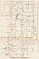
Main Author:
U.S. Geological Survey
Title/Description:
Geologic Map of Parts of Cotton and Jefferson Counties, Oklahoma
Publication Info:
Washington: Department of the Interior, U.S. Geological Survey, 1915; Bulletin 602 Plate V
Viewing Options
Main Author:
U.S. Geological Survey
Title/Description:
Map of the Lawton Oil and Gas Field and Adjacent Territory, Oklahoma
Publication Info:
Washington: Department of the Interior, U.S. Geological Survey, 1915; Bulletin 621 Plate XI
Viewing Options
Main Author:
U.S. Geological Survey
Title/Description:
Map of the Duncan Gas Field, Stephens County, Oklahoma
Publication Info:
Washington: Department of the Interior, U.S. Geological Survey, 1915; Bulletin 621 Plate VIII
Viewing Options
Main Author:
U.S. Geological Survey
Title/Description:
Map of the Healdton Oil Field, Carter County, Oklahoma
Publication Info:
Washington: Department of the Interior, U.S. Geological Survey, 1915; Bulletin 621 Plate III
Viewing Options
Main Author:
Oklahoma Geological Survey
Title/Description:
Map showing the Distribution of the Mississippian Rocks in Northeastern Oklahoma
Publication Info:
Norman: Oklahoma Geological Survey, 1915; Bulletin No. 24
Viewing Options
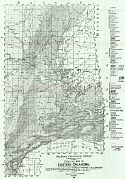
Main Author:
Oklahoma Geological Survey
Title/Description:
Geological Map of Eastern Oklahoma
Publication Info:
Norman: Oklahoma Geological Survey, 1915; Bulletin No. 19
Viewing Options
Title/Description:
Geological Map of Arbuckle Mountains
Publication Info:
Norman: Oklahoma Geological Survey, 1915
Viewing Options
Main Author:
Oklahoma Geological Survey
Title/Description:
Geologic Map of the Wichita Mountains
Publication Info:
Norman: Oklahoma Geological Survey, 1915; Bulletin No. 20

