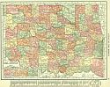
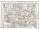
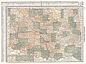
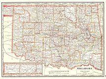
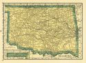
Viewing Options
Main Author:
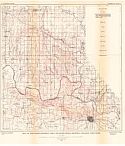
Rand McNally and Company
Title/Description:
Oklahoma
Publication Info:
Chicago: Rand McNally and Co., 1916; from The Ideal Atlas of the World
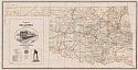
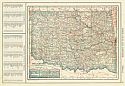
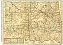
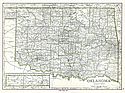
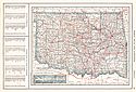
Viewing Options
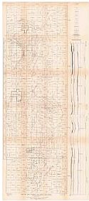
Main Author:
Corporation Commission of Oklahoma
Title/Description:
Railroad Map of Oklahoma
Publication Info:
Oklahoma City: Corporation Commission of Oklahoma, 1917
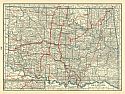
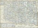
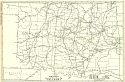
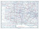
Viewing Options
Main Author:
C.S. Hammond and Company
Title/Description:
Oklahoma
Publication Info:
New York: C.S. Hammond and Company, 1917; from The Universal Atlas of the World
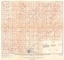
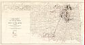
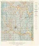
Viewing Options
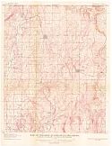
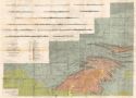
Main Author:
U.S. Geological Survey
Title/Description:
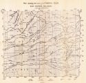
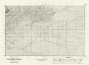
Topographic Map of the Northern Part of the Bristow Quadrangle, Oklahoma showing Provisional Interpretation of Geologic Structure
Publication Info:
Washington: Department of the Interior, U.S. Geological Survey, 1917; Bulletin 661 Plate IV
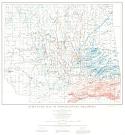
Viewing Options
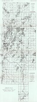
Main Author:
U.S. Geological Survey
Title/Description:
Map of the Cushing Oil Field, Oklahoma showing Surface Structure
Publication Info:
Washington: Department of the Interior, U.S. Geological Survey, 1917; Bulletin 658 Plate V
Viewing Options
Main Author:
U.S. Geological Survey
Title/Description:
Map of Foraker Quadrangle showing topography and structure contours
Publication Info:
Washington: Department of the Interior, U.S. Geological Survey, 1917; Bulletin 641 Plate 2
Viewing Options
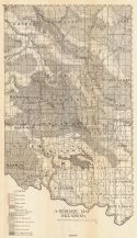
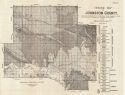
Main Author:
Oklahoma Geological Survey
Title/Description:
Production Map of Washington County
Publication Info:
Norman: Oklahoma Geological Survey, 1917; Bulletin No. 19
Viewing Options
Main Author:
Geological Survey of Oklahoma
Title/Description:
A Geological Map of the Western Portion of Oklahoma
Publication Info:
Norman: Oklahoma Geological Survey, 1917; Bulletin No. 19
Viewing Options
Main Author:
Oklahoma Geological Survey
Title/Description:
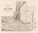
Geologic Map of Atoka County
Publication Info:
Norman: Oklahoma Geological Survey, 1917; Bulletin No. 19
Viewing Options
Main Author:
Oklahoma Geological Survey
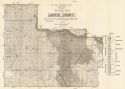
Title/Description:
Geologic Map of Carter County
Publication Info:
Norman: Oklahoma Geological Survey, 1917; Bulletin No. 19
Viewing Options
Main Author:
Oklahoma Geological Survey
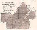
Title/Description:
Geologic Map of Haskell County
Publication Info:
Norman: Oklahoma Geological Survey, 1917
Viewing Options
Main Author:
Oklahoma Geological Survey
Title/Description:
Map Showing the axes of the Principal Folds in East Central Oklahoma
Publication Info:
Norman: Oklahoma Geological Survey, 1917; Bulletin No. 19
Viewing Options
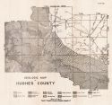
Main Author:
Oklahoma Geological Survey
Title/Description:
Geologic Map of Hughes County
Publication Info:
Norman: Oklahoma Geological Survey, 1917; Bulletin No. 19
Viewing Options
Main Author:
Oklahoma Geological Survey
Title/Description:
Geologic Map of Johnston County
Publication Info:
Norman: Oklahoma Geological Survey, 1917; Bulletin No. 19
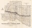
Viewing Options
Main Author:
Oklahoma Geological Survey
Title/Description:
General Geologic Map of Choctaw, McCurtain, and Pushmataha Counties
Publication Info:
Norman: Oklahoma Geological Survey, 1917; Bulletin No. 19
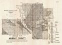
Viewing Options
Main Author:
Oklahoma Geological Survey
Title/Description:
Geological Map of Murray County
Publication Info:
Norman: Oklahoma Geological Survey, 1917; Bulletin No. 19
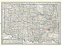
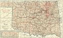
Viewing Options
Main Author:
C.S. Hammond and Company
Title/Description:
Oklahoma
Publication Info:
New York: C.S. Hammond and Company, 1918; from Hammonds Pictorial Atlas of the World
Viewing Options
Main Author:
Reynolds, Francis J.
Title/Description:
Oklahoma
Publication Info:
New York: P.F. Collier and Son Company, 1920; from The New World Atlas and Gazetteer
Viewing Options
Main Author:
Cram, George F.
Title/Description:
Oklahoma
Publication Info:
Chicago: James R. Gray and Company, 1920; from Cram's Unrivaled Atlas of the World
Viewing Options
Main Author:
C.S. Hammond and Company
Title/Description:
Oklahoma
Publication Info:
New York: C.S. Hammond and Company, 1920; from The New Reference Atlas of the World
Original Source:
Courtesy of Shawn Carter
Viewing Options
Main Author:
Leslie-Judge Company
Title/Description:
Oklahoma
Publication Info:
New York: Leslie-Judge Company1920; from Leslie's New World Atlas
Viewing Options
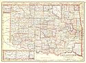
Main Author:
Rand McNally and Company
Title/Description:
Oklahoma
Publication Info:
Chicago: Rand McNally and Company, 1921; from The Commercial Atlas of America
Viewing Options
Main Author:
Rand McNally and Company
Title/Description:
Oklahoma- Black and White Mileage Map
Publication Info:
Chicago: Rand McNally and Company, 1921; from The Commercial Atlas of America
Viewing Options
Main Author:
U.S. Geological Survey
Title/Description:
Oil and Gas Fields of the State of Oklahoma
Publication Info:
Washington: Department of the Interior, U.S. Geological Survey, 1921
Viewing Options
Main Author:
Cram, George F.
Title/Description:
Oklahoma
Publication Info:
Chicago: George F. Cram Company, 1921; from Cram's Unrivaled Atlas of the World
Viewing Options
Main Author:
National Map Company
Title/Description:
Oklahoma
Publication Info:
Indianapolis: National Map Company, 1921; from Auto Trails and Commercial Survey of the United States
Viewing Options
Main Author:
National Map Company
Title/Description:
Oklahoma
Publication Info:
Indianapolis: National Map Company, 1921; from Auto Trails and Commercial Survey of the United States
Viewing Options
Main Author:
C.S. Hammond
Title/Description:
Oklahoma
Publication Info:
New York: C.S. Hammond and Company, 1922; from The New World Loose-leaf Atlas
Viewing Options
Main Author:
U.S. Geological Survey
Title/Description:
Map of the Madill-Denison Area Oklahoma-Texas, Showing Geologic Structure
Publication Info:
Washington: Department of the Interior, U.S. Geological Survey, 1922; Bulletin 736 Plate 4
Viewing Options
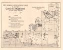
Main Author:
Honess, C.W.
Title/Description:
Geologic Map and Sections of Southern Ouachita Mountains in South-East Oklahoma
Publication Info:
Norman: Oklahoma Geological Survey, 1923; Bulletin No. 32
Viewing Options
Main Author:
Oklahoma Geological Survey
Title/Description:
Map Showing Classification of Lands in Southern Ouachita Mountains in South-eastern Oklahoma
Publication Info:
Norman: Oklahoma Geological Survey, 1923; Bulletin No. 32
Viewing Options
Main Author:
Cram, George F.
Title/Description:
Oklahoma
Publication Info:
Chicago: George F. Cram Company, 1923; from Cram's Unrivaled Atlas of the World
Viewing Options
Main Author:
Funk and Wagnalls Company
Title/Description:
Oklahoma
Publication Info:
New York: Funk and Wagnalls Company, 1923; from Atlas of the World and Gazetteer
Viewing Options
Main Author:
U.S. Geological Survey
Title/Description:
Areal Geologic Map of Bristow Quadrangle, Oklahoma
Publication Info:
Washington: Department of the Interior, U.S. Geological Survey, 1924; Bulletin 759 Plate 2
Viewing Options
Main Author:
Reynolds, Francis J.
Title/Description:
Oklahoma
Publication Info:
New York: P.F. Collier and Son Company, 1924; from The New World Atlas and Gazetteer
Viewing Options
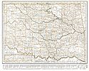
Main Author:
Oklahoma Geological Survey
Title/Description:
Structure Map of Northeastern Oklahoma
Publication Info:
Norman: Oklahoma Geological Survey, 1925
Viewing Options
Main Author:
Rothrock, E.P.
Title/Description:
Geologic Map of Cimarron County
Publication Info:
Norman: Oklahoma Geological Survey, 1925; Bulletin No 34
Viewing Options
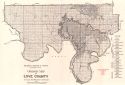
Main Author:
Bullard, Fred M.
Title/Description:
Geological Map of Love County
Publication Info:
Norman: Oklahoma Geological Survey, 1925; Bulletin No. 33
Viewing Options
Main Author:
Rand McNally and Company
Title/Description:
Oklahoma
Publication Info:
Chicago: Rand McNally and Company, 1925; from Premier Atlas of the World

