Viewing Options
Main Author:
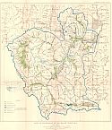
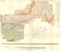
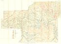
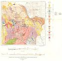
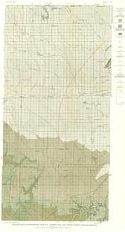
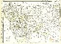
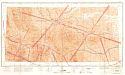
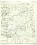
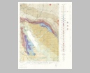
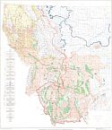
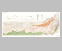
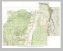
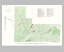
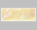
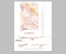
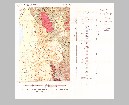
U.S. Geological Survey
Title/Description:
Map of Jefferson River Basin, Montana
Publication Info:
Washington: Department of the Interior, U.S. Geological Survey, 1926; from Water Supply Paper No. 580 Plate 3
Viewing Options
Main Author:
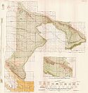
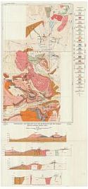
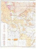
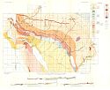
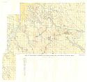
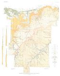
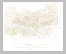
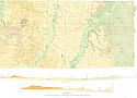
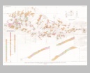
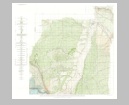
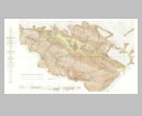
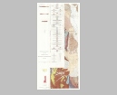
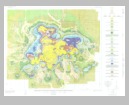
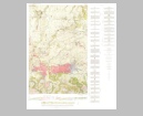
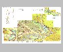
U.S. Geological Survey
Title/Description:
Map and Sections Showing Areal and Structural Geology of a part of the Cat Creek-Devils Basin Uplift, Montana
Publication Info:
Washington: Department of the Interior, U.S. Geological Survey, 1927; Bulletin 786 Plate 3
Viewing Options
Main Author:
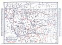
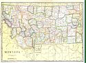
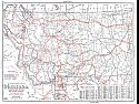
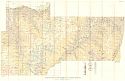
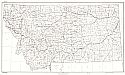
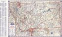
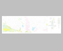
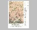
Clason Map Company
Title/Description:
Best Roads of Montana
Publication Info:
Chicago: Clason Map Company, c. 1927; from Clason's Touring Atlas
Viewing Options
Main Author:
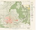
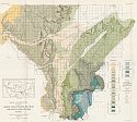
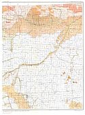
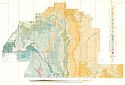
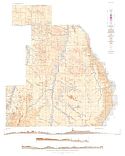
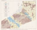
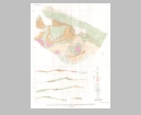
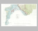
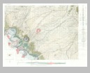
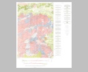
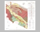
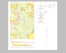
U.S. Geological Survey
Title/Description:
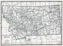
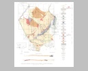
Map showing Areal and Structural Geology of the Highwood Mountains and adjacent Plains, Montana
Publication Info:
Washington: Department of the Interior, U.S. Geological Survey, 1928; Bulletin 806 Plate 44
Viewing Options
Main Author:
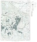
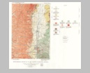
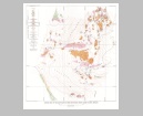
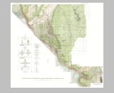
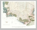
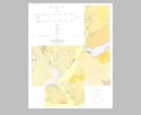
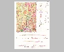
U.S. Geological Survey
Title/Description:
Geologic Map and Sections of Yellowstone and Treasure Counties, Montana
Publication Info:
Washington: Department of the Interior, U.S. Geological Survey, 1928; Water Supply Paper No. 599 Plate 1
Viewing Options
Main Author:
U.S. Geological Survey
Title/Description:
Topographic and Geologic Map and Sections of the New World Mining District, Montana-Wyoming
Publication Info:
Washington: Department of the Interior, U.S. Geological Survey, 1929; Bulletin 811 Plate 1
Viewing Options
Main Author:
U.S. Geological Survey
Title/Description:
Geologic and Structure map of parts of Carbon, Yellowstone, Big Horn, and Stillwater Counties, Montana
Publication Info:
Washington: Department of the Interior, U.S. Geological Survey, 1930; Bulletin 822 Plate 1
Viewing Options
Main Author:
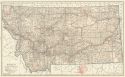
National Map Company
Title/Description:
Montana
Publication Info:
Indianapolis: National Map Company, 1930; from Official Paved Road and Commercial Survey of the United States
Viewing Options
Main Author:
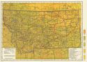
Clason Map Company
Title/Description:
Clason's Road Map of Montana
Publication Info:
Denver: The Clason Map Company, 1930; from Clason's Touring Atlas of the United States and Canada
Viewing Options
Main Author:
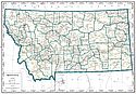
C.S. Hammond and Company
Title/Description:
Montana
Publication Info:
New York: C.S. Hammond and Company, c. 1930; from The New World Loose Leaf Atlas, Sixth Edition
Viewing Options
Main Author:
C.S. Hammond and Company
Title/Description:
Montana
Publication Info:
New York: C.S. Hammond and Company, c. 1930; from The New World Loose Leaf Atlas, Sixth Edition
Viewing Options
Main Author:
Geographical Publishing Company
Title/Description:
Montana
Publication Info:
Chicago: Geographical Publishing Company1931; from Commercial Atlas of the World
Viewing Options
Main Author:
U.S. Geological Survey
Title/Description:
Geologic Map of the Ashland Coal Field, Montana
Publication Info:
Washington: Department of the Interior, US Geological Survey, 1932; Bulletin 831, Plate 3
Viewing Options
Viewing Options
Main Author:
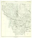
U.S. Geological Survey
Title/Description:
Map Showing physiographic and glacial geology of Montana and parts of adjacent states
Publication Info:
Washington: Department of the Interior, US Geological Survey, 1932; Professional Paper 174, Plate 1
Viewing Options
Main Author:
U.S. Geological Survey
Title/Description:
Map Showing area of Boulder Batholith and traces of over thrust faults
Publication Info:
Washington: Department of the Interior, US Geological Survey, 1933; Bulletin 842, Plate 1
Viewing Options
Main Author:
U.S. Geological Survey
Title/Description:
Geologic map and sections of Greater Helena Mining District, Montana
Publication Info:
Washington: Department of the Interior, US Geological Survey, 1933; Bulletin 842, Plate 2
Viewing Options
Main Author:
U.S. Geological Survey
Title/Description:
Geologic Map and sections of York-Confederate Gulch Area
Publication Info:
Washington: Department of the Interior, US Geological Survey, 1933; Bulletin 842, Plate 15
Viewing Options
Main Author:
U.S. Geological Survey
Title/Description:
Geologic map and section of Bighorn County and part of Yellowstone County, Montana
Publication Info:
Washington: Department of the Interior, US Geological Survey, 1934; Bulletin 856, Plate 1
Viewing Options
Main Author:
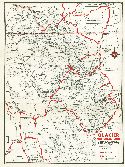
Continental Oil Company
Title/Description:
Glacier National Park
Publication Info:
Chicago: H.M. Gousha Company, 1934
Original Source:
Murray Hudson
Viewing Options
Main Author:
U.S. Geological Survey
Title/Description:
Geologic Map of north-central Chouteau, Western Hill and Eastern Liberty Counties, Montana
Publication Info:
Washington: Department of the Interior, US Geological Survey, 1936; Bulletin 847, Plate 43
Viewing Options
Main Author:
U.S. Geological Survey
Title/Description:
Map of the Richey-Lambert Coal Field, Richland and Dawson Counties, Montana
Publication Info:
Washington: Department of the Interior, US Geological Survey, 1936; Bulletin 847c, Plate 22
Viewing Options
Main Author:
U.S. Geological Survey
Title/Description:
Geologic Map of the Rosebud Coal Field, Montana
Publication Info:
Washington: Department of the Interior, US Geological Survey, 1936; Bulletin 847, Plate 11
Viewing Options
Main Author:
Branom, Frederick K. and Lloyd Edwin Smith
Title/Description:
Montana
Publication Info:
Chicago: Geographical Publishing Company, 1936; from Capper's 1936 Atlas of the World
Viewing Options
Main Author:
Rand McNally and Company
Title/Description:
Standard Map of Montana
Publication Info:
Chicago: Rand McNally and Company, 1936
Viewing Options
Main Author:
U.S. Geological Survey
Title/Description:
Geologic Map and Sections of McCone County, Montana
Publication Info:
Washington: Department of the Interior, US Geological Survey, 1938; Bulletin 8905, Plate 1
Viewing Options
Main Author:
U.S. Geological Survey
Title/Description:
Geologic Map and Sections of the Mispah Coal Field, Montana
Publication Info:
Washington: Department of the Interior, US Geological Survey, 1939; Bulletin 906, Plate 16
Viewing Options
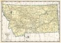
Main Author:
U.S. Geological Survey
Title/Description:
State of Montana
Publication Info:
Washington.: Department of the Interior, U.S. Geological Survey, 1940; compiled 1913, revised 1923
Viewing Options
Main Author:
U.S. Coast and Geodetic Survey
Title/Description:
Butte Sectional Aeronautical Chart
Publication Info:
Washington: U.S. Coast and Geodetic Survey, 1940
Viewing Options
Main Author:
Geographical Publishing Company
Title/Description:
Montana
Publication Info:
Chicago: Geographical Publishing Company, 1942; from The New International Atlas of the World, War Edition
Viewing Options
Main Author:
Bureau of the Census
Title/Description:
Montana Irrigation by Drainage Basins, 1939
Publication Info:
Washington: U.S. Government Printing Office, 1942
Viewing Options
Viewing Options
Main Author:
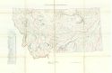
Andrews, D.A., G.G. Lambert and G.W. Stose
Title/Description:
Geological Map of Montana
Publication Info:
Washington: Department of the Interior, U.S. Geological Survey, 1944
Viewing Options
Main Author:
U.S. Geological Survey
Title/Description:
Geologic Map and Sections of the Western Part of the Stillwater Complex, Sweetgrass County, Montana
Publication Info:
Washington: Department of the Interior, US Geological Survey, 1949; Bulletin 948-C, Plate 34
Viewing Options
Main Author:
U.S. Geological Survey
Title/Description:
Reconnaissance Geologic Map and Sections of Part of Beaverhead and Madison Counties, Montana
Publication Info:
Washington: Department of the Interior, US Geological Survey, 1950; Bulletin 969-C, Plate 16
Viewing Options
Main Author:
Montana State Highway Commission
Title/Description:
Map of the Montana State Highway System
Publication Info:
Helena: Montana State Highway Commission, 1951
Viewing Options
Main Author:
U.S. Geological Survey
Title/Description:
Geologic Map of the Canyon Ferry Quadrangle, Montana
Publication Info:
Washington.: Department of the Interior, U.S. Geological Survey, 1951; Bulletin 972, Plate 1
Viewing Options
Main Author:
U.S. Geological Survey
Title/Description:
Geologic Map and Sections of Coalwood Coal Field, Powder River County, Montana
Publication Info:
Washington.: Department of the Interior, U.S. Geological Survey, 1952; Bulletin 973, Plate 1
Viewing Options
Main Author:
U.S. Geological Survey
Title/Description:
Geologic Map of the Corundum Deposits of Gallatin and Madison Counties, Montana
Publication Info:
Washington: Department of the Interior, U.S. Geological Survey, 1952; Bulletin No. 983
Viewing Options
Main Author:
U.S. Geological Survey
Title/Description:
Reconnaissance Geologic Map of the Hamilton Quadrangle, Montana
Publication Info:
Washington: Department of the Interior, U.S. Geological Survey, 1952; Bulletin No. 974-E Plate 4
Viewing Options
Main Author:
U.S. Geological Survey
Title/Description:
Physiography and Glacial Geology of Western Montana
Publication Info:
Washington.: Department of the Interior, U.S. Geological Survey, 1953; Professional Paper 231, Plate 1
Viewing Options
Main Author:
U.S. Geological Survey
Title/Description:
Geologic Map and Sections of the Chromite Deposits of the West Fork of Stillwater River, Sweet Grass County, Montana
Publication Info:
Washington: Department of the Interior, U.S. Geological Survey, 1955; Bulletin No. 1015-D Plate 11
Viewing Options
Main Author:
U.S. Geological Survey
Title/Description:
Geologic Map and Sections of the East Boulder Plateau Chromite Deposits, Sweet Grass County, Montana
Publication Info:
Washington: Department of the Interior, U.S. Geological Survey, 1955; Bulletin No. 1015-D Plate 9
Viewing Options
Main Author:
U.S. Geological Survey
Title/Description:
Geologic Map of the East Slope of Iron Mountain, Sweet Grass County, Montana
Publication Info:
Washington: Department of the Interior, U.S. Geological Survey, 1955; Bulletin No. 1015-D Plate 10
Viewing Options
Main Author:
U.S. Geological Survey
Title/Description:
Geologic Map and Sections of Central Part of the Stillwater Complex, Sweet Grass County, Montana
Publication Info:
Washington: Department of the Interior, U.S. Geological Survey, 1955; Bulletin No. 1015-D Plate 8
Viewing Options
Main Author:
U.S. Geological Survey
Title/Description:
Geologic and Structure Contour Map of the Bighorn Canyon-Hardin Area, Montana and Wyoming (North Half)
Publication Info:
Washington: Department of the Interior, U.S. Geological Survey, 1955; Bulletin No. 1026 Plate 1
Viewing Options
Main Author:
U.S. Geological Survey
Title/Description:
Geologic and Structure Contour Map of the Bighorn Canyon-Hardin Area, Montana and Wyoming (South Half)
Publication Info:
Washington: Department of the Interior, U.S. Geological Survey, 1955; Bulletin No. 1026 Plate 1
Viewing Options
Main Author:
U.S. Geological Survey
Title/Description:
Map Showing Geology and Bentonite Deposits of the Hardin District, Montana and Wyoming (South Half)
Publication Info:
Washington: Department of the Interior, U.S. Geological Survey, 1956; Bulletin No. 1023 Plate 1
Viewing Options
Main Author:
U.S. Geological Survey
Title/Description:
Map Showing Geology and Bentonite Deposits of the Hardin District, Montana and Wyoming (North Half)
Publication Info:
Washington: Department of the Interior, U.S. Geological Survey, 1956; Bulletin No. 1023 Plate 1
Viewing Options
Main Author:
U.S. Geological Survey
Title/Description:
Reconnaissance Geologic Map and Section of the Western Part of Mineral County, Montana
Publication Info:
Washington: Department of the Interior, U.S. Geological Survey, 1956; Bulletin No. 1027-M Plate 48
Viewing Options
Main Author:
U.S. Geological Survey
Title/Description:
Geologic Map and Section of the Stanford-Hobson Area, Central Montana (North Half)
Publication Info:
Washington: Department of the Interior, U.S. Geological Survey, 1956; Bulletin No. 1027-J Plate 45
Viewing Options
Main Author:
U.S. Geological Survey
Title/Description:
Geologic Map and Section of the Stanford-Hobson Area, Central Montana (South Half)
Publication Info:
Washington: Department of the Interior, U.S. Geological Survey, 1956; Bulletin No. 1027-J Plate 45
Viewing Options
Main Author:
U.S. Geological Survey
Title/Description:
Generalized Geologic Map of Parts of Park and Sweet Grass Counties, Montana, Showing Sources of Optical Calcite
Publication Info:
Washington: Department of the Interior, U.S. Geological Survey, 1958; Bulletin No. 1042-M Plate 23
Viewing Options
Main Author:
U.S. Geological Survey
Title/Description:
Geologic Map and Sections of Part of the Townsend Valley, Broadwater and Jefferson Counties, Montana
Publication Info:
Washington: Department of the Interior, U.S. Geological Survey, 1958; Bulletin No. 1042-N Plate 42
Viewing Options
Main Author:
U.S. Geological Survey
Title/Description:
Geologic Map and Sections of the Maddux Quadrangle, Blaine County, Montana
Publication Info:
Washington: Department of the Interior, U.S. Geological Survey, 1959; Bulletin 1081-C Plate 3
Viewing Options
Main Author:
U.S. Geological Survey
Title/Description:
Geologic Map of the Smoke Creek-Medicine Lake- Grenora Area, Montana and North Dakota (Western Part)
Publication Info:
Washington: Department of the Interior, U.S. Geological Survey, 1959; Bulletin 1073 Plate 1
Viewing Options
Main Author:
U.S. Geological Survey
Title/Description:
Geologic Map of the Smoke Creek-Medicine Lake- Grenora Area, Montana and North Dakota (Eastern Part)
Publication Info:
Washington: Department of the Interior, U.S. Geological Survey, 1959; Bulletin 1073 Plate 1
Viewing Options
Main Author:
U.S. Geological Survey
Title/Description:
Geologic Map of Little Rocky Mountains and Encircling Foothills, Montana
Publication Info:
Washington: Department of the Interior, U.S. Geological Survey, 1959; Bulletin 1072-N Plate 52
Viewing Options
Main Author:
U.S. Geological Survey
Title/Description:
Geologic Map of the Lower Marias River Area, Chouteau, Hill, and Liberty Counties, Montana
Publication Info:
Washington: Department of the Interior, U.S. Geological Survey, 1959; Bulletin 1071-E Plate 10
Viewing Options
Main Author:
U.S. Geological Survey
Title/Description:
Reconnaissance Geologic Map of the St. Regis-Superior Area, Mineral County, Montana
Publication Info:
Washington: Department of the Interior, U.S. Geological Survey, 1960; Bulletin 1082-I Plate 28
Viewing Options
Main Author:
U.S. Geological Survey
Title/Description:
Geologic Map and Sections of the Bonner Quadrangle, Montana
Publication Info:
Washington: Department of the Interior, U.S. Geological Survey, 1961; Bulletin 1111-F Plate 35
Viewing Options
Main Author:
U.S. Geological Survey
Title/Description:
Geologic Map and Sections of the Lloyd Quadrangle, Blaine County, Montana
Publication Info:
Washington: Department of the Interior, U.S. Geological Survey, 1961; Bulletin 1081-E Plate 6
Viewing Options
Main Author:
U.S. Geological Survey
Title/Description:
Geologic Map and Generalized Sections of the Otter Creek Quadrangle, Montana
Publication Info:
Washington: Department of the Interior, U.S. Geological Survey, 1962; Bulletin 1111-G Plate 37
Viewing Options
Main Author:
U.S. Geological Survey
Title/Description:
Geologic Map and Sections of the Basin Quadrangle, Jefferson, Lewis and Clark, and Powell Counties, Montana
Publication Info:
Washington: Department of the Interior, U.S. Geological Survey, 1963; Bulletin 1151 Plate 1
Viewing Options
Main Author:
U.S. Geological Survey
Title/Description:
Geologic Map and Sections of the Duck Creek Pass Quadrangle, Montana
Publication Info:
Washington: Department of the Interior, U.S. Geological Survey, 1963; Bulletin 1121-J Plate 1
Viewing Options
Main Author:
U.S. Geological Survey
Title/Description:
Geologic Map and Sections of the Winnett-Mosby Area, Petroleum, Garfield, Rosebud, and Furgus Counties, Montana
Publication Info:
Washington: Department of the Interior, U.S. Geological Survey, 1964; Bulletin 1149 Plate 1
Viewing Options
Main Author:
U.S. Geological Survey
Title/Description:
Geologic Map and Sections of the Cleveland Triangle, Blaine County, Montana
Publication Info:
Washington: Department of the Interior, U.S. Geological Survey, 1964; Bulletin 1141-P Plate 1

