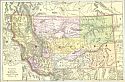
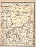
Viewing Options
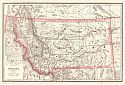
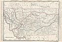
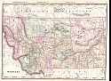
Main Author:
Watson, Gaylord
Title/Description:
Montana
Publication Info:
New York: Gaylord Watson and R.A. Tenney, 1885; from The New and Complete Illustrated Atlas of the World
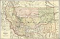
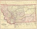
Viewing Options
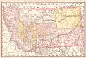
Main Author:
Cram, George F.
Title/Description:
Montana
Publication Info:
Chicago: Henry S. Stebbins, 1885; from The Unrivaled Family Atlas of the World
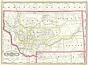
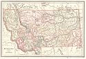
Viewing Options
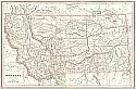
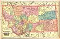
Main Author:
Cram, George F.
Title/Description:
Railroad and County Map of Montana
Publication Info:
New York: A.A. Grant, 1887; from Grant's Standard American Atlas of the World
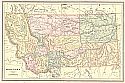
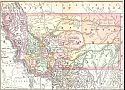
Viewing Options
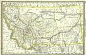
Main Author:
Cram, George F.
Title/Description:
Montana
Publication Info:
Chicago: Henry S. Stebbins, 1887; from Cram's Universal Atlas of the World
Viewing Options
Main Author:
The Peoples Publishing Company
Title/Description:
Montana
Publication Info:
Chicago: The Peoples Publishing Company, 1887; from The Peoples' Unrivaled Family Atlas of the World
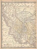
Viewing Options
Main Author:
Rand McNally & Company
Title/Description:
Territory of Montana
Publication Info:
Chicago: Rand McNally & Co., 1888; from Rand McNally's New Indexed Atlas of the World
Viewing Options
Main Author:
Peoples Publishing Company
Title/Description:
Montana
Publication Info:
Rochester, NY: W.H. Stewart and Co., 1888; from The Peoples' Illustrated and Descriptive Family Atlas of the World
Viewing Options
Main Author:
Rand McNally and Company
Title/Description:
Montana
Publication Info:
Chicago: Rand McNally and Co., 1889; from the Enlarged Business Atlas and Shippers Guide
Viewing Options
Main Author:
Cram, George F.
Title/Description:
Montana
Publication Info:
Chicago: George F. Cram, c.1890
Viewing Options
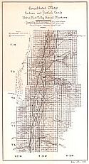
Main Author:
Carrington, H. B.
Title/Description:
Consolidated Map of Indian Settler's Lands in Bitter Root Valley, State of Montana
Publication Info:
Washington: U.S. Department of the Interior, 1890; compiled by H.B. Carrington, U.S.A., Special Agent of Interior Department, to appraise said lands, under Act of Congress, approved March 2nd 1889
Viewing Options
Main Author:
Tunison, Henry C.
Title/Description:
Tunison's Montana
Publication Info:
Jacksonville, IL: H.C. Tunison, 1890
Viewing Options
Viewing Options
Main Author:
Rand McNally & Co.
Title/Description:
Map of Montana
Publication Info:
Chicago: Rand McNally & Co., 1890; from Rand McNally & Co.'s Family Atlas of the World
Viewing Options
Main Author:
Mast, Crowell and Kirkpatrick
Title/Description:
Map of Montana
Publication Info:
Chicago: Mast, Crowell and Kirkpatrick, c.1890
Viewing Options
Main Author:
Cram, George F.
Title/Description:
Montana
Publication Info:
Rochester: W.H. Stewart, c. 1890; from Cram's Unrivaled Atlas of the World
Viewing Options
Main Author:
Rand McNally and Company
Title/Description:
Montana
Publication Info:
Chicago: Rand McNally and Company, c.1890
Viewing Options
Main Author:
Walker, Henry B.
Title/Description:
Montana
Publication Info:
Philadelphia: H.B. Walker, 1890; from Walker's International Atlas

